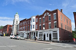
Litchfield is a town in and former county seat of Litchfield County, Connecticut, United States. The population was 8,192 at the 2020 census. The town is part of the Northwest Hills Planning Region. The boroughs of Bantam and Litchfield are located within the town. There are also three unincorporated villages: East Litchfield, Milton, and Northfield. Northfield, located in the southeastern corner of Litchfield, is home to a high percentage of the Litchfield population.

Chatfield Hollow State Park is a public recreation area occupying 412 acres (167 ha) that lie adjacent to Cockaponset State Forest in the town of Killingworth, Connecticut. The state park offers hiking trails, a swimming beach, trout fishing, mountain biking, rock climbing, and picnicking areas. Park attractions include 6.67-acre (2.70 ha) Schreeder Pond, Indian caves, historic sites, a restored water wheel, and a reproduction covered bridge. The park is managed by the Connecticut Department of Energy and Environmental Protection.
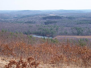
Mohawk State Forest, also known as Mohawk State Forest/Mohawk Mountain State Park, encompasses over 4,000 acres (1,600 ha) in the towns of Cornwall, Goshen, and Litchfield in the southern Berkshires of Litchfield County, Connecticut. As overseen by the Connecticut Department of Energy and Environmental Protection, the area is used for hiking, picnicking, and winter sports by the public, while being actively managed to produce timber and other forest products.

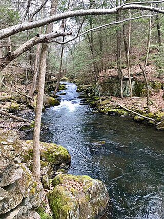
Northfield is an unincorporated village in the town of Litchfield, Litchfield County, Connecticut.
Wharton Brook State Park is a public recreation area located off U.S. Route 5 in the towns of North Haven and Wallingford, Connecticut. Activities in the 96-acre (39 ha) state park center on Allen Brook Pond, a 5-acre (2.0 ha) pond that empties into Wharton Brook. The park is managed by the Connecticut Department of Energy and Environmental Protection.

Seth Low Pierrepont State Park Reserve is a public recreation area covering 305 acres (123 ha) in the town of Ridgefield, Connecticut. The state park offers opportunities for hiking, fishing, and boating.

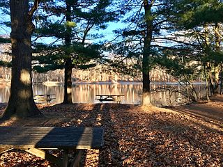
Mount Tom State Park is a public recreation area lying south of US Route 202 in the towns of Washington, Litchfield, and Morris, Connecticut. The state park occupies 231 acres (93 ha) on the southwest shore of Mount Tom Pond and is home to the Mount Tom Tower, which was listed on the National Register of Historic Places in 1993. It is managed by the Connecticut Department of Energy and Environmental Protection.
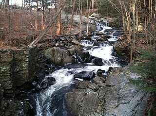
Southford Falls State Park is a public recreation area covering 126 acres (51 ha) in the towns of Oxford and Southbury, Connecticut. The state park offers fishing, hiking, waterfalls, a fire tower, and a covered bridge over Eight Mile Brook. It is managed by the Connecticut Department of Energy and Environmental Protection.

The Pequonnock River is a 16.7-mile-long (26.9 km) waterway in eastern Fairfield County, Connecticut. Its watershed is located in five communities, with the majority of it located within Monroe, Trumbull, and Bridgeport. The river has a penchant for flooding, particularly in spring since the removal of a retention dam in Trumbull in the 1950s. There seems to be a sharp difference of opinion among historians as to just what the Indian word Pequonnock signifies. Some insist it meant cleared field or open ground; others are sure it meant broken ground; while a third group is certain it meant place of slaughter or place of destruction.
The 'Hancock Brook Trail' is a 2.8-mile (4.5 km) Blue-Blazed hiking trail Waterville Section of the City of Waterbury in New Haven County close to the borders of Thomaston and Plymouth, Litchfield County, Connecticut. It is contained overwhelmingly in a section of the Mattatuck State Forest bounded by Hancock Brook on the east, Thomaston Avenue on the west and Spruce Brook Road / Route 262 to the north.

The Jericho trail is a 3.4-mile (5.5 km) Blue-Blazed hiking trail in the Oakville section of Watertown, near the border with Thomaston and Plymouth, Litchfield County, Connecticut. The trail is contained almost entirely in a section of the Mattatuck State Forest. The mainline trail is a linear north–south "hike-through" trail with one east–west connector trail to the Whitestone Cliffs Blue-Blazed Trail.
Old Furnace State Park is a public recreation area adjacent to Ross Pond State Park in the town of Killingly, Connecticut. The state parks covers 367 acres (149 ha), sits at an elevation of 390 feet (120 m), and is open year-round for hiking, hunting, and fishing. It is located east of Interstate 395, south of U.S. Route 6 and north of Connecticut Route 695. The park is the site of a former iron furnace. It was established as a town park in 1909 before being transferred to the state in 1918.

The Beckley Furnace Industrial Monument is a state-owned historic site preserving a 19th-century iron-making blast furnace on the north bank of the Blackberry River in the town of North Canaan, Connecticut. The site became a 12-acre (4.9 ha) state park in 1946; it was added to the National Register of Historic Places in 1978.

Dennis Hill State Park is a public recreation area located in the town of Norfolk, Connecticut, that was once the estate of Dr. Frederick Shepard Dennis. The state park offers hiking, picnicking, and scenic views. It is administered by the Connecticut Department of Energy and Environmental Protection.
John A. Minetto State Park is a public recreation area encompassing 715 acres (289 ha) in the towns of Goshen and Torrington, Connecticut. Facilities are available for picnicking, fishing, and cross-country skiing. The state park is managed by the Connecticut Department of Energy and Environmental Protection.

Hopeville Pond State Park is a public recreation area located on Hopeville Pond, an impoundment of the Pachaug River, in the town of Griswold, Connecticut. A portion of the 554-acre (224 ha) state park occupies the site of the lost village of Hopeville. The park manager's house occupies Avery House, which is listed on the National Register of Historic Places. The park offers fishing, swimming, camping, and trails for hiking and biking. It is managed by the Connecticut Department of Energy and Environmental Protection.
George Dudley Seymour State Park is a public recreation area occupying 222 acres (90 ha) on the east bank of the Connecticut River in the town of Haddam, Connecticut. Hurd State Park abuts the park to the north. The park bears the name of George Dudley Seymour (1859-1945), whose philanthropic efforts enabled the state to purchase land for this and several other Connecticut state parks. It is managed by the Connecticut Department of Energy and Environmental Protection.

Nehantic State Forest is a publicly owned forest and recreation area occupying two parcels, one in the town of Lyme and one in the towns of East Lyme and Salem, in the state of Connecticut. The forest, which totals 5,062 acres (2,049 ha), is the site of regular prescribed burns and timber-harvesting operations. Purchase of the land began in 1926, when it became the first state forest located in New London County. It is managed by the Connecticut Department of Energy and Environmental Protection.
The J. Howard Catlin House was a historic house at 14 Knife Shop Road in Litchfield, Connecticut. Built about 1879, it was a distinctive vernacular example of Carpenter Gothic architecture. It was built for J. Howard Catlin, one of the owners of the Northfield Knife Company, whose plant was located just to the east. The house was listed on the National Register of Historic Places; it was subsequently demolished to make way for a fire station.


