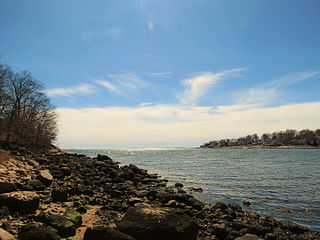
Rocky Neck State Park is a public recreation area on Long Island Sound in the town of East Lyme, Connecticut, United States. The state park's 708 acres (287 ha) include a tidal river, a broad salt marsh, white sand beaches, rocky shores, and a large stone pavilion dating from the 1930s. It is managed by the Connecticut Department of Energy and Environmental Protection.

Cockaponset State Forest is the second largest forest in the Connecticut state forest system, encompassing over 17,000 acres (6,900 ha) of land. Most of the land is in Middlesex County though some parcels lie in New Haven County. The forest is disjointed, and comprises land in the towns of Haddam, Chester, Deep River, Killingworth, Durham, Guilford, Madison, Clinton, Westbrook, Middletown and Middlefield.

Gay City State Park is a public recreation area on the Blackledge River in the towns of Hebron and Bolton, Connecticut. The state park occupies 1,569 acres (635 ha) bordering Meshomasic State Forest and is accessible from State Route 85. In addition to its deep forest, millpond, and marshland, the park bears trace remnants of the mill town that occupied the site for most of the 19th century. The park is managed by the Connecticut Department of Energy and Environmental Protection.

Indian Well State Park is a public recreation area occupying 153 acres (62 ha) on the west bank of Lake Housatonic, an impoundment of the Housatonic River, within the city limits of Shelton, Connecticut. The state park's scenic features include a 15-foot (4.6 m) horsetail waterfalls with splash pool at bottom. The park is managed by the Connecticut Department of Energy and Environmental Protection.

Burr Pond State Park is a public recreation area covering 438 acres (177 ha) adjacent to Paugnut State Forest in the town of Torrington, Connecticut. The state park surrounds Burr Pond, an 85-acre (34 ha), man-made body of water with facilities for swimming, boating, and fishing. It is managed by the Connecticut Department of Energy and Environmental Protection.

Whittemore Glen State Park is an undeveloped public recreation and wilderness area for hiking and horseback riding covering 242 acres (98 ha) mostly within the town of Naugatuck, Connecticut. Sitting outside the southwestern edge of the city of Waterbury, the state park is the eastern terminus of the Larkin State Park Trail. It entered the roles as Connecticut's forty-eighth state park in the 1945–46 edition of the Connecticut Register and Manual. The park is managed by the Connecticut Department of Energy and Environmental Protection.

Mono Pond State Park Reserve is a public recreation area covering 218 acres (88 ha) in the town of Columbia, Connecticut, 8 miles (13 km) southwest of Willimantic. The state park surrounds Mono Pond, a 113-acre (46 ha) body of water averaging depths of 3.5 feet (1.1 m) with an area near the dam reaching a depth of nine feet (2.7 m). The park offers fishing, hiking, picnicking, cross-country skiing, bow hunting, and a boat launch for motorized and non-motorized boating. The park is managed by the Connecticut Department of Energy and Environmental Protection and was added to the roll of Connecticut state parks in 2008.

Beaver Brook State Park is an undeveloped public recreation area covering 401 acres (162 ha) in the towns of Windham and Chaplin, Connecticut. The state park encompasses Bibbins Pond, also known as Beaver Brook Pond, as well as the acreage northward as far as the Air Line State Park Trail, which forms the park's northern boundary. The park is a walk-in facility, open for hunting and trout fishing, managed by the Connecticut Department of Energy and Environmental Protection.
Ross Pond State Park is a public recreation area covering 314 acres (127 ha) in the town of Killingly, Connecticut. The state park offers hiking, hunting, fishing, and a boat launch. It sits adjacent to Old Furnace State Park and a blue-blazed trail connects the two. Ross Pond State Park entered the Connecticut Register and Manual in 1964 as a state park of 181 acres (73 ha).

Lamentation Mountain State Park is an undeveloped public recreation area covering 47 acres (19 ha) in the town of Berlin, Connecticut. It entered the roll of state parks in the 1936 edition of the Connecticut Register and Manual. The state park extends for about 0.4 miles (0.64 km) from the Berlin Turnpike up the western flank of Lamentation Mountain to the ridgeline near the Mattabesett Trail. The park offers hiking and scenic vistas.
Windsor Meadows State Park is a public recreation area on the west side of the Connecticut River in the town of Windsor, Connecticut. The state park occupies three largely undeveloped sections measuring 48, 19, and 88 acres located between railroad tracks and the river. Park activities include picnicking, fishing, boating, hiking, and biking.

Quaddick State Park is a public recreation area located on 203-acre (82 ha) Middle Quaddick Reservoir in the town of Thompson, Connecticut. The state park is managed by the Connecticut Department of Energy and Environmental Protection and offers opportunities for boating, swimming, fishing, and picnicking.
John A. Minetto State Park is a public recreation area encompassing 715 acres (289 ha) in the towns of Goshen and Torrington, Connecticut. Facilities are available for picnicking, fishing, and cross-country skiing. The state park is managed by the Connecticut Department of Energy and Environmental Protection.

Mount Riga State Park is an undeveloped public recreation area located in the town of Salisbury, Connecticut. The state park offers opportunities for hiking and bow hunting. The Undermountain Trail connects to the northernmost section of the Appalachian Trail in Connecticut from the trail head at Mount Riga State Park's parking lot on Connecticut Route 41. The park is managed by the Connecticut Department of Energy and Environmental Protection.

Satan's Kingdom State Recreation Area is a public recreation area occupying one-acre of land beside the Farmington River in the town of New Hartford, Connecticut. The site is located on the north side of the Route 44 bridge over the Farmington River. It is used as a put-in for canoeing, kayaking, and tubing excursions on the river.
Sunnybrook State Park is a public recreation area encompassing 464 acres (188 ha) in the town of Torrington, Connecticut. The state park is the southwestern terminus for the blue-blazed John Muir Trail which crosses Paugnut State Forest for two miles to the loop trail at Burr Pond State Park. Another park trail bears the name of former property owner Edwin Fadoir. In addition to hiking, the park offers picnicking, hunting, and fishing along the East Branch Naugatuck River. The park opened in 1970 and entered the state roles in the 1971 edition of the Connecticut Register and Manual.

Farm River State Park is a privately operated, publicly owned recreation area on the western shore of the Farm River estuary in the town of East Haven, Connecticut. Public access to the 62-acre state park is limited and boating is restricted to those with passes obtained from Quinnipiac University, which manages the park for the Connecticut Department of Energy and Environmental Protection. Park activities include nature trail hiking, bird watching, and fishing.

Brainard Homestead State Park, and alternatively Brainerd Homestead State Park, is a 25-acre (10 ha) undeveloped state park located in the town of East Haddam, Connecticut, United States. A farmhouse was built on the site by Timothy Green in 1842 before being purchased by Selden Tyler Brainerd in March 1854. The ownership of the property was willed to Geraldine W. Hayden. Upon her death in 1929, the property was willed to the State of Connecticut with the condition that William Brainerd be able to use the property for life. William Brainerd died in 1936, the buildings were later dismantled, but the Brainard Homestead State Park was established prior to May 1, 1932. The undeveloped park is said to offer bird watching, sports fields and hiking according to the Connecticut Department of Energy and Environmental Protection. As of 2012, the fields were noted to be farmed and there were no established trails for hiking.
James L. Goodwin State Forest is a Connecticut state forest covering approximately 2,000 acres (810 ha) in the towns of Chaplin and Hampton. The lands became public property when James L. Goodwin donated the personal forest he had been developing since 1913 to the state in 1964.

Centennial Watershed State Forest is a Connecticut state forest of more than 15,000 acres with larger parcels located in the towns of Easton, Newtown, Redding, and Weston. Dozens of other properties are strung throughout much of Southwestern part of the state. In 2002, the lands were acquired from the Aquarion Water Company by the state in partnership with The Nature Conservancy. Those three entities continue to manage the property by committee. The forest was named in honor of the hundredth anniversary of the state forest system.