
Interstate 91 (I-91) is an Interstate Highway in the New England region of the United States. It is the primary north–south thoroughfare in the western part of the region. Its southern terminus is in New Haven, Connecticut, at I-95, while the northern terminus is in Derby Line, Vermont, at the Canada–United States border. Past the Derby Line–Rock Island Border Crossing, the road continues into Canada as Quebec Autoroute 55. I-91 is the longest of three Interstate highways whose entire route is located within the New England states and is also the only primary (two-digit) Interstate Highway in New England to intersect all five of the other highways that run through the region. The largest cities along its route, from south to north, are New Haven, Connecticut; Hartford, Connecticut; Springfield, Massachusetts; Northampton, Massachusetts; Greenfield, Massachusetts; Brattleboro, Vermont; White River Junction, Vermont; St. Johnsbury, Vermont; and Newport, Vermont.
Windsor is a town in Hartford County, Connecticut, United States, and was the first English settlement in the state. It lies on the northern border of Connecticut's capital, Hartford. The town is part of the Capitol Planning Region. The population of Windsor was 29,492 at the 2020 census.

U.S. Route 5 (US 5) is a north–south United States Numbered Highway running through the New England states of Connecticut, Massachusetts, and Vermont. Significant cities along the route include New Haven, Connecticut; Hartford, Connecticut; and Springfield, Massachusetts. From Hartford northward to St. Johnsbury, Vermont, the road closely follows the route of the Connecticut River.
State Road 23 (SR 23), also known as the First Coast Expressway, is a controlled-access toll road serving as an outer bypass around the southwest quadrant of Jacksonville, Florida. As of 2024, the first phase has been built, linking Interstate 10 (I-10) near Whitehouse with SR 21 in the Middleburg area. The second phase to Green Cove Springs is currently under construction, and is expected to be completed in the second half of 2025.

Route 15 is a state highway in the U.S. state of Connecticut that runs 83.53 miles (134.43 km) from a connection with New York's Hutchinson River Parkway in Greenwich, Connecticut, to its northern terminus intersecting with Interstate 84 (I-84) in East Hartford, Connecticut. Route 15 consists of four distinct sections: the Merritt Parkway, the Wilbur Cross Parkway, most of the Berlin Turnpike, and part of the Wilbur Cross Highway. The unified designation was applied to these separate highways in 1948 to provide a continuous through route from New York to Massachusetts. The parkway section of Route 15 is often referred to locally as "The Merritt".
Shunpiking is the act of deliberately avoiding roads that require payment of a fee or toll to travel on them, usually by traveling on alternative "free" roads which bypass the toll road. The term comes from the word shun, meaning "to avoid", and pike, a term referring to turnpikes, which is another name for toll roads. People who often avoid toll roads sometimes call themselves shunpikers. Historically, certain paths around tollbooths came to be so well known they were called "shun-pikes".

Interstate 84 (I-84) is an Interstate Highway in the Northeastern United States that extends almost 233 miles from Dunmore, Pennsylvania, near Scranton at an interchange with I-81 east to Sturbridge, Massachusetts, at an interchange with the Massachusetts Turnpike (I-90). Among the major cities that the road passes through is Hartford, Connecticut, and the road provides a major portion of the primary route between New York City and Boston. Another highway named I-84 is located in the Northwestern United States.
The Connecticut Turnpike is a freeway and former toll road in the U.S. state of Connecticut; it is maintained by the Connecticut Department of Transportation (ConnDOT). Spanning approximately 128 miles (206 km) along a generally west–east axis, its roadbed is shared with Interstate 95 (I-95) for 88 miles (142 km) from the New York state border in Greenwich to East Lyme; I-395 for 36 miles (58 km) from East Lyme to Plainfield; and SR 695 for four miles (6.4 km) from Plainfield to the Rhode Island state line at U.S. Route 6 (US 6) in Killingly. The turnpike briefly runs concurrently with US 1 from Old Saybrook to Old Lyme and Route 2A from Montville to Norwich.

Interstate 291 (I-291) is a short auxiliary Interstate Highway in the state of Connecticut that starts at I-91 at its junction with Route 218 in Windsor and ends at I-84 in Manchester. It serves as a northeastern bypass of Hartford. According to the Federal Highway Administration, the official length of I-291 is 6.02 miles (9.69 km); however, the Connecticut Department of Transportation (CTDOT) includes the 0.38 miles (0.61 km) of the exit ramp that I-291 uses to merge with eastbound I-84, making their recorded length 6.4 miles (10.3 km) long.

Route 9 is a 40.89-mile-long (65.81 km) expressway running from Interstate 95 (I-95) in Old Saybrook north to I-84 in Farmington. It connects the Eastern Coastline of the state along with the Lower Connecticut River Valley to Hartford and the Capital Region.

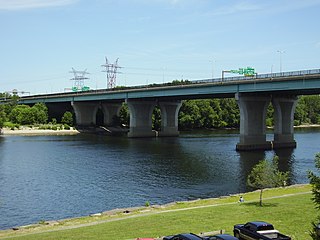
The Bulkeley Bridge is the oldest of three highway bridges over the Connecticut River between Hartford, Connecticut and East Hartford, Connecticut. A stone arch bridge composed of nine spans, the bridge carries Interstate 84, U.S. Route 6, and U.S. Route 44 across the river. As of 2005, the bridge carried an average daily traffic of 142,500 cars. The arches are mounted on stone piers, and vary in length from 68 feet (21 m) to 119 feet (36 m); the total length of the bridge is 1,192 feet (363 m).

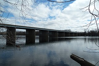
The Founders Bridge is one of the three highway bridges over the Connecticut River between Hartford, Connecticut and East Hartford, Connecticut. The steel stringer bridge carries the Route 2 freeway, and also crosses over Interstate 91. As of 2013 the bridge had an average daily traffic of 29,200.
Isaac Bissell was a patriot post rider who delivered mail between Boston and Hartford, Connecticut. On April 19, 1775, the British made an attack on Lexington and Concord, igniting the American Revolutionary War. He was assigned to alert American colonists of the news and rally them to assist the Massachusetts minutemen. Traveling from Watertown, Massachusetts, on the Upper Post Road to Hartford, Connecticut, and through Connecticut Colony, he carried the Lexington Alarm message from Joseph Palmer. He rode again in July 1779 to deliver the New Haven Alarm. Bissell served the Connecticut Militia throughout the Revolutionary War.
The Charter Oak Bridge is one of the three highway bridges over the Connecticut River between Hartford, Connecticut and East Hartford, Connecticut. The twin steel stringer bridge carries the Wilbur Cross Highway over the river.

The Wilbur Cross Highway is a freeway running along a portion of Connecticut Route 15 and U.S. Route 5 from Wethersfield to East Hartford, Connecticut, and then continuing northeast as a section of Interstate 84, part of which is also cosigned as U.S. Route 6. The freeway ends at a junction with the tolled Massachusetts Turnpike in Sturbridge, Massachusetts. The entire route was formerly signed as Route 15.

The Putnam Bridge is a bridge in the state of Connecticut carrying the Route 3 freeway over the Connecticut River, connecting Interstate 91 in Wethersfield and Route 2 in Glastonbury. It is the southernmost crossing of the Connecticut River in the Hartford Area and carries an average of 50,800 vehicles per day.
U.S. Route 5 (US 5), a north–south United States Numbered Highway that is generally paralleled by Interstate 91 (I-91), begins at the city of New Haven in Connecticut and heads north through western Massachusetts and eastern Vermont to the international border with Canada. Within Connecticut, US 5 proceeds north from New Haven and passes through Meriden and Hartford toward Springfield, Massachusetts.
Interstate 84 (I-84) is an east–west Interstate Highway across the state of Connecticut through Danbury, Waterbury, Hartford, and Union.
Windsor Meadows State Park is a public recreation area on the west side of the Connecticut River in the town of Windsor, Connecticut. The state park occupies three largely undeveloped sections measuring 48, 19, and 88 acres located between railroad tracks and the river. Park activities include picnicking, fishing, boating, hiking, and biking.

