Interstate 91 (I-91) is an Interstate Highway in the New England region of the United States. It is the primary north–south thoroughfare in the western part of the region. Its southern terminus is in New Haven, Connecticut, at I-95, while the northern terminus is in Derby Line, Vermont, at the Canada–United States border. Past the Derby Line–Rock Island Border Crossing, the road continues into Canada as Quebec Autoroute 55. I-91 is the longest of three Interstate highways whose entire route is located within the New England states and is also the only primary (two-digit) Interstate Highway in New England to intersect all five of the other highways that run through the region. The largest cities along its route, from south to north, are New Haven, Connecticut; Hartford, Connecticut; Springfield, Massachusetts; Northampton, Massachusetts; Greenfield, Massachusetts; Brattleboro, Vermont; White River Junction, Vermont; St. Johnsbury, Vermont; and Newport, Vermont.

Glastonbury is a town in the Capitol Planning Region, Connecticut, United States, formally founded in 1693 and first settled in 1636. It was named after Glastonbury in Somerset, England. Glastonbury is on the banks of the Connecticut River, 7 miles (11 km) southeast of Hartford. The town center is defined by the U.S. Census Bureau as a census-designated place (CDP). The population was 35,159 at the 2020 census.

Rocky Hill is a town in Hartford County, Connecticut, United States. The town is part of the Capitol Planning Region. The population was 20,845 at the 2020 census. It was originally land of the Wangunks. Europeans began to settle the area of Rocky Hill in 1650, as part of Wethersfield, the neighboring town to the north. In 1722, the area became known as Stepney Parish, until it was independently incorporated in 1843. Rocky Hill’s location on the Connecticut River made it a natural port for Wethersfield and an early center for shipbuilding, agriculture, and trade.

Wethersfield is a town located in Hartford County, Connecticut, United States. It is located immediately south of Hartford along the Connecticut River. The town is part of the Capitol Planning Region. The population was 27,298 at the time of the 2020 census.

U.S. Route 5 (US 5) is a north–south United States Numbered Highway running through the New England states of Connecticut, Massachusetts, and Vermont. Significant cities along the route include New Haven, Connecticut; Hartford, Connecticut; and Springfield, Massachusetts. From Hartford northward to St. Johnsbury, Vermont, the road closely follows the route of the Connecticut River.

Route 15 is a state highway in the U.S. state of Connecticut that runs 83.53 miles (134.43 km) from a connection with New York's Hutchinson River Parkway in Greenwich, Connecticut, to its northern terminus intersecting with Interstate 84 (I-84) in East Hartford, Connecticut. Route 15 consists of four distinct sections: the Merritt Parkway, the Wilbur Cross Parkway, most of the Berlin Turnpike, and part of the Wilbur Cross Highway. The unified designation was applied to these separate highways in 1948 to provide a continuous through route from New York to Massachusetts. The parkway section of Route 15 is often referred to locally as "The Merritt".

Interstate 84 (I-84) is an Interstate Highway in the Northeastern United States that extends from Dunmore, Pennsylvania, near Scranton at an interchange with I-81 east to Sturbridge, Massachusetts, at an interchange with the Massachusetts Turnpike (I-90). Among the major cities that the road passes through is Hartford, Connecticut, and the road provides a major portion of the primary route between New York City and Boston. Another highway named I-84 is located in the Northwestern United States.

Interstate 395 (I-395) is an auxiliary Interstate Highway in the U.S. states of Connecticut and Massachusetts; it is maintained by the Connecticut Department of Transportation (CTDOT) and the Massachusetts Department of Transportation (MassDOT). Spanning nearly 67 miles (108 km) on a south–north axis, it is the only spur route of I-95 in Connecticut. The 36-mile (58 km) section between its splits from I-95 in East Lyme and SR 695 in Plainfield is a component highway of the Connecticut Turnpike. Within that state, the highway is named the American Ex-Prisoner of War Memorial Highway from Plainfield to Thompson.

Route 17 is a primary north–south state route beginning in New Haven, through Middletown, and ending in Glastonbury, with a length of 36.33 miles (58.47 km).

Route 9 is a 40.89-mile-long (65.81 km) expressway beginning in Old Saybrook and ending at I-84 near the Farmington–West Hartford town line. It connects the Eastern Coastline of the state along with the Lower Connecticut River Valley to Hartford and the Capital Region.

Route 3 is a 14.48-mile-long (23.30 km) route connecting Middletown to the Glastonbury-East Hartford town line. It passes through the towns of Cromwell, Rocky Hill, Wethersfield, and Glastonbury. The northernmost 3 miles (4.8 km) of Route 3 is a freeway that was originally intended for the cancelled Interstate 491.

Route 2 is a 58.03-mile (93.39 km) state highway in Hartford and New London counties in Connecticut. It is a primary state route, with a freeway section connecting Hartford to Norwich and following surface roads to Stonington. The entire freeway section of Route 2 west of Route 169 is also known as the Veterans of Foreign Wars Memorial Highway Though it is labelled an east-west highway, it follows a northwest-southeast route, with large sections of the highway running north-south throughout its duration.

The Bulkeley Bridge is the oldest of three highway bridges over the Connecticut River between Hartford, Connecticut and East Hartford, Connecticut. A stone arch bridge composed of nine spans, the bridge carries Interstate 84, U.S. Route 6, and U.S. Route 44 across the river. As of 2005, the bridge carried an average daily traffic of 142,500 cars. The arches are mounted on stone piers, and vary in length from 68 feet (21 m) to 119 feet (36 m); the total length of the bridge is 1,192 feet (363 m).

Interstate 95 (I-95) is the main north–south Interstate Highway on the East Coast of the United States, running in a general east–west compass direction for 111.57 miles (179.55 km) in Connecticut, from the New York state line to the Rhode Island state line. I-95 from Greenwich to East Lyme is part of the Connecticut Turnpike, during which it passes through the major cities of Stamford, Bridgeport, and New Haven. After leaving the turnpike in East Lyme, I-95 is known as the Jewish War Veterans Memorial Highway and passes through New London, Groton, and Mystic, before exiting the state through North Stonington at the Rhode Island border.

The Founders Bridge is one of the three highway bridges over the Connecticut River between Hartford, Connecticut and East Hartford, Connecticut. The steel stringer bridge carries the Route 2 freeway, and also crosses over Interstate 91. As of 2013 the bridge had an average daily traffic of 29,200.

The Wilbur Cross Highway is a freeway running along a portion of Connecticut Route 15 and U.S. Route 5 from Wethersfield to East Hartford, Connecticut, and then continuing northeast as a section of Interstate 84, part of which is also cosigned as U.S. Route 6. The freeway ends at a junction with the tolled Massachusetts Turnpike in Sturbridge, Massachusetts. The entire route was formerly signed as Route 15.

Route 99 is a state highway in Connecticut running for 10.64 miles (17.12 km) from Route 9 in Cromwell, through the town of Rocky Hill, ending in Wethersfield at the Hartford city line. The road continues into Hartford as a local road. It follows the former alignment of Route 9 from prior to that route's upgrade to a freeway.
U.S. Route 5 (US 5), a north–south United States Numbered Highway that is generally paralleled by Interstate 91 (I-91), begins at the city of New Haven in Connecticut and heads north through western Massachusetts and eastern Vermont to the international border with Canada. Within Connecticut, US 5 proceeds north from New Haven and passes through Meriden and Hartford toward Springfield, Massachusetts.

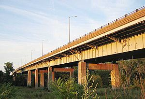
The Captain John Bissell Memorial Bridge carries I-291 over the Connecticut River, connecting the towns of Windsor, Connecticut and South Windsor, Connecticut. There is a pedestrian crossing on the bridge on the westbound, upstream side.

U.S. Route 44 (US 44) is an east–west United States Numbered Highway that runs for 237 miles (381 km) through four states in the Northeastern United States. The western terminus is at US 209 and New York State Route 55 (NY 55) in Kerhonkson, New York, a hamlet in the Hudson Valley region. The eastern terminus is at Route 3A in Plymouth, Massachusetts.