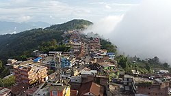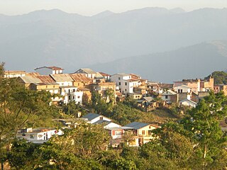
Dhankuta is a hill town and the headquarters of Dhankuta District in Koshi Province in Eastern Nepal. According to 2011 Nepal census, it has population of 26,440 inhabitants.

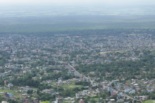
Biratnagar is a metropolitan city in Nepal, which serves as the capital of Koshi Province. With a Metropolitan Urban Agglomeration population of 244,750 as per the 2021 census, it is the largest city and fastest growing city in the province and also the headquarters of Morang district. As per the preliminary report of 2022 Nepal census, Biratnagar Metropolitan has an estimated city population of 243,927 excluding the suburban areas which are now very well connected to the old town. It is the administrative center of the Greater Birat Development Area which incorporates the cities of Biratnagar and its suburbs and towns of-Itahari-Gothgau-Biratchowk-Dharan primarily located on the Koshi Highway in Eastern Nepal, with an estimated total urban agglomerated population of 804,300 people in 159,332 households including the town of Ithari. Biratnagar is located 399 km (248 mi) east of the capital, Kathmandu, and 6 km (3.7 mi) north of the bordering town of Jogbani in the Indian state of Bihar. It is one of the major entry point in Nepal for Businessmen as well as Tourists who come to visit Nepal for various purposes.

Bhojpur is one of the two urban municipalities of Bhojpur District of Province No. 1 of Nepal.
Dharan is a sub-metropolitan city in Sunsari District of Koshi Province, in eastern Nepal, which was established as a fourth municipality in the Kingdom in 1958. It is the third most populous city in eastern Nepal after Biratnagar and Itahari. The Nepali word "dharan" means a saw pit. The rainforest from which the tree trunks came is still just on the edge of the city. Much later the British Gurkha camp opened in October 1960. The use of the camp by British Gurkhas finished in the mid-1990s. Dharan has an estimated city population of 173,096 living in 34,834 households as per the 2021 Nepal census. It is one of the cities of the Greater Birat Development Area which incorporates the cities of Biratnagar-Itahari-Gothgau-Biratchowk-Dharan primarily located on the Koshi Highway in Eastern Nepal, with an estimated total urban agglomerated population of 804,300 people living in 159,332 households. It is the largest city in the province number one by Area. It covers 192.32 square kilometers while Biratnagar and Itahari is 2nd and 3rd biggest cities by Area

Dhankuta District is one of 14 districts of Koshi Province of eastern Nepal. The district covers an area of 891 km2 (344 sq mi) and has a population (2011) of 163,412. The hill town of Dhankuta serves as the district headquarters of Dhankuta District.

Taplejung District is one of 77 districts of Nepal and one of the 14 districts of Koshi Province. It is located deep in the Himalayas in Eastern Nepal with བོད to the north across the Himalayas. Taplejung is the third largest district of Nepal.

Udayapur District (Nepali: उदयपुर जिल्ला, is one of the 14 districts of Koshi Province in eastern Nepal. The district, with Triyuga as its district headquarters, covers an area of 2,063 km2 and in 2001 had a population of 287,689, in 2011 of 317,532, in 2021 of 342,773

Butwal, officially Butwal Sub-Metropolitan City ,previously known as Khasyauli, is a sub-metropolitan city and economic hub in Lumbini Province in West Nepal. Butwal has a city population of 195,054 as per the 2021 AD Nepal census.

Ilam is one of four urban municipalities of Ilam District, which lies in the Mahabharata hilly range of Koshi Province, eastern Nepal. Ilam also acts as the headquarters of Ilam District. Being the largest producer region for Nepali tea, its tea farms are a major tourist attraction in Koshi Province. Ilam is also famous for its natural scenery and landscapes as well as its diverse agricultural economy which specializes in horticultural crop production.

Khandbari is the district headquarters of Sankhuwasabha District in Koshi Province of north-eastern Nepal.

Mahendra Highway or NH01, also called East-West Highway, runs across the Terai geographical region of Nepal, from Mechinagar in the east to Bhim Datta in the west, cutting across the entire width of the country. It is the longest highway in Nepal and was constructed in cooperation with various countries. The highway is named after King Mahendra Shah.
Basantapur is a city located in the Himalayan Therathum District of Koshi Province, Nepal. It is the main city of Laligurans Municipality and is known for its beautiful rhododendron forests, snow-covered peaks during the winter season, and stunning natural scenery. Basantapur is often referred to as the "gate of capital city of rhododendrons" due to its abundance of these vibrant flowers.

Bhedetar is a village development committee in Dhankuta District in the Koshi Province of eastern Nepal. The main settlement began when the Dharan - Dhankuta Highway was completed in 1982. At the time of the 1991 Nepal census it had a population of 2643 people living in 513 individual households. It is 1,420 meters high from the sea level. It is actually on the border line of Sunsari and Dhankuta districts.

Barahachhetra is a Hindu and Kirat piligram site which remains between the confluence of Koka and Koshi rivers in Barahakshetra, Sunsari of Koshi Province, Nepal. This place is one of Nepal's oldest shrines mentioned in Puranas including Brahma Purana, Varaha Purana and Skanda Purana and even mentioned and glorified in the Mahabharata epic. In Barahachhetra, the Varah, an incarnation of Vishnu is worshiped. Barahachhetra is one of the Char Dham in Nepal.

Phidim Municipality is the headquarters of the Panchthar District in the Koshi Province of eastern Nepal. Phidim was upgraded to a 'municipality' from a 'village', when a development committee merged with other VDCs - including the Phidim, Chokmagu and Siwa villages - on May 18, 2014. It offers a route for trekkers and locals, who travel to and from the Taplejung district bordering with the Tibetan Autonomous Region of China. It is also a commercial hub for the rural surroundings.
Rajghat is a small village in the Urlabari Municipality, comprising two wards; 8 and 9 in the Morang District in the Koshi Zone of south-eastern Nepal. It is located in North-East part of Morang and 1.5 kilometers south of the East West national highway of Nepal. Durgapuri Bazar is the local town of Rajghat. This place is one of the major habitat of indigenous Dhimal, Santhal,and Mushahar communities.

Koshi Province is the autonomous easternmost province adopted on 20 September 2015 by Constitution of Nepal. The province is rich in natural resources, tourist attractions, recreational activities, and natural beauty. The province covers an area of 25,905 km2 (10,002 sq mi), about 17.5% of the country's total area. With the industrial city of Biratnagar as its capital, the province includes major eastern towns of Birtamod, Sundar Haraincha, Damak, Dharan, Itahari, Triyuga Municipality and Mechinagar, and the Mount Everest, Kangchenjunga and Ama Dablam. Koshi River, the largest river of the nation, forms the province's western boundary. Under the First-past-the-post voting system issued by the Constituency Delimitation Commission, Nepal, the province hosts 28 parliamentary seats and 56 provincial assembly seats.

Ramdhuni is a municipality located in the Sunsari district, Koshi Province of Eastern Nepal. It was established in 2014. Ramdhuni previously known as Jhumka Bazar. It is approximately 356km far from Kathmandu. This town lies in the middle of two famous cities Itahari and Inaruwa. Mahendra highway passes right through the heart of the town. Chatara Canal originates all the way from Koshi River and flows through the town from north to south. This canal plays an important role in the agriculture of Sunsari and Morang district. Ramdhuni has a total area of 91.69 square kilometers. It has a population of 63,452 of which 29,820 are males and 29,820 are females living in 11,491 individual houses.
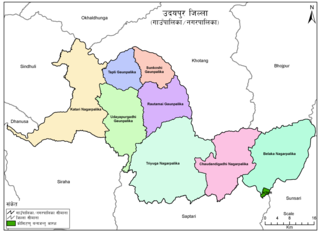
Belaka is a municipality located in Udayapur District of Province No. 1 of Nepal. It is one of four urban municipalities located in Udayapur District.

Koshi Province covers an area of 25,905 square kilometres (10,002 sq mi). It is located at easternmost part of Nepal bordering by Tibet Autonomous Region of China in north Bagmati Province in west, Province No. 2 in south-west, Bihar of India in south, North Bengal of India in south-east and Sikkim of India in north-east. Sikkim and part of North Bengal of India forms ethno-linguistic relation with Nepal. Geography of Koshi Province in eastern Nepal is very diverse, of highest peaks of Himalayas in northern extremes to terai region to south. It lies between 86 degree 1 minute and 88 degree 3 minutes east longitude and 28 degree 2 minutes and 26 degree 3 minutes north longitude. Biratnagar, the industrial capital of Nepal, is the temporary capital of this province.