
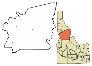
Lewis County is a county located in the north central region of the U.S. state of Idaho. As of the 2020 census, the population was 3,533, making it the fourth-least populous county in Idaho. The county seat is Nezperce, and Kamiah is the largest city. Partitioned from Nez Perce County and established in 1911, it was named after the explorer Meriwether Lewis. Most of the county is within the Nez Perce Indian Reservation, though Native Americans comprise less than 6% of the county population. Similar to the opening of lands in Oklahoma, the U.S. government opened the reservation for white settlement in November 1895. The proclamation had been signed less than two weeks earlier by President Cleveland.

Camas County is a county in the southern portion of the U.S. state of Idaho. The county seat and largest city is Fairfield. The county was established 107 years ago in 1917 by the Idaho Legislature with a partition of Blaine County on February 6. It is named for the camas root, or Camassia, a lily-like plant with an edible bulb found in the region, that Native Americans and settlers used as a food source. As of the 2020 census, the population was 1,077, making it the second-least populous county in the state, after Clark County.

Blaine County is a county in the U.S. state of Idaho. As of the 2020 United States Census, the population was 24,272. The county seat and largest city is Hailey. It is also home to the Sun Valley ski resort, adjacent to Ketchum.

Cottonwood is a city in Idaho County, Idaho. On the Camas Prairie in north central Idaho, the population was 822 at the 2020 census, down from 900 in 2010 and 944 in 2000. It is just west of U.S. Route 95, between Grangeville and Lewiston.
Ferdinand is a city in Idaho County, Idaho, United States. The population was 159 at the 2010 census, up from 145 in 2000. At the southern end of the Nez Perce Indian Reservation, it was founded by F.M. Bieker shortly after the reservation was opened for settlement in 1895. It was named after Ferdinand, Indiana, where his mother's family had lived.

Grangeville is the largest city in and the county seat of Idaho County, Idaho, United States, in the north central part of the state. Its population was 3,141 at the 2010 census, down from 3,228 in 2000.

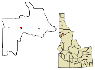
Kamiah is a city in Lewis and Idaho counties in the U.S. state of Idaho. The largest city in Lewis County, it extends only a small distance into Idaho County, south of Lawyer Creek. The population was 1,295 at the 2010 census, up from 1,160 in 2000. The city lies in the narrow valley of the Clearwater River; downstream are Orofino and Lewiston, at the confluence with the Snake River.
Craigmont is a city in the northwest United States in Lewis County, Idaho. Located on the Camas Prairie in north central Idaho, it is within the Nez Perce Indian Reservation. The population was 501 at the 2010 census, down from 556 in 2000.

Nezperce is a city in and the county seat of Lewis County, Idaho, United States. The population was 466 at the 2010 census, down from 523 in 2000. Nezperce is named for the local Nez Perce tribe of Native Americans. There is one school district, Nezperce School District #302.

Winchester is a city in western Lewis County, Idaho, United States, located on the Camas Prairie in the north central part of the state. The population was 356 at the 2020 census, up from 340 in 2010. Winchester Lake State Park lies south of the city.
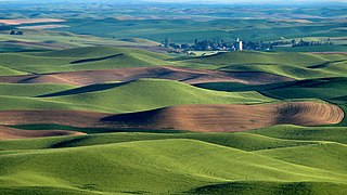
The Palouse is a distinct geographic region of the northwestern United States, encompassing parts of north central Idaho, southeastern Washington, and, by some definitions, parts of northeast Oregon. It is a major agricultural area, primarily producing wheat and legumes. Situated about 160 miles (260 km) north of the Oregon Trail, the region experienced rapid growth in the late 19th century.

Camassia is a genus of plants in the asparagus family native to North America. Common names include camas, quamash, Indian hyacinth, camash, and wild hyacinth.

Camas prairies are found in several different geographical areas in the western United States, and are named for the native perennial camas (Camassia). The culturally and scientifically significant of these areas lie within Idaho and Montana. Camas bulbs were an important food source for Native Americans.

Camas Prairie Railroad Company was a short line railroad in northern Idaho jointly owned and operated by Northern Pacific Railway and Union Pacific.

Central Idaho is a geographical term for the region located northeast of Boise and southeast of Lewiston in the U.S. state of Idaho. It is dominated by federal lands administered by the United States Forest Service and the Bureau of Land Management. Idaho's tallest mountain, Borah Peak, is located in this region. A large part of the Sawtooth National Recreation Area is within Central Idaho.
The BG&CM Railroad or Bountiful Grain and Craig Mountain Railroad is a Class III shortline railroad located in North Central Idaho.
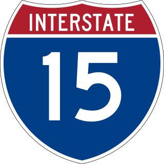
Interstate 15 (I-15) is a part of the Interstate Highway System that runs from San Diego, California, to Sweetgrass, Montana. In Idaho, the Interstate Highway runs exactly 196 miles (315 km) from the Utah state line near Woodruff north to the Montana state line at Monida Pass. I-15 is the primary north–south highway of Eastern Idaho. The Interstate Highway connects Pocatello and Idaho Falls, the fourth and fifth largest cities in Idaho, and the smaller county seats of Malad City, Blackfoot, and Dubois. I-15 connects all of those cities with Salt Lake City to the south and Butte to the north. The Interstate has business loops through McCammon, Inkom, Pocatello, Blackfoot, and Idaho Falls.

Weippe Prairie is a "beautiful upland prairie field of about two by three miles bordered by farmland made from cleared pine forests" at 3,000 feet elevation in Clearwater County, Idaho, at Weippe, Idaho. Camas flowers grow well there, and attracted native gatherers of the camas roots. It is the location in Idaho where the Lewis and Clark Expedition emerged from crossing the Bitterroot Mountains on the Lolo Trail and first met the Nez Perce tribe of Native Americans.
Fenn is an unincorporated community in Idaho County, Idaho, United States. It is located on U.S. Route 95 on the Camas Prairie, seven miles (11 km) northwest of Grangeville and eight miles (13 km) south of Cottonwood. Fenn had a post office with ZIP code 83531.

Camas Prairie Centennial Marsh Wildlife Management Area at 3,100 acres (13 km2) is an Idaho wildlife management area in Camas County south of the community of Hill City. The WMA is at the base of the Bennett Hills on the Camas Prairie south of the Soldier Mountains and Sawtooth National Forest. The Idaho Department of Fish and Game acquired the land in 1987 with the help of Ducks Unlimited and The Nature Conservancy to provide quality wetland and upland habitat for migratory and resident wildlife.


