Reading is a town and borough in Berkshire, England. Located in the Thames Valley at the confluence of the rivers Thames and Kennet, Reading is 40 miles (64 km) east of Swindon, 24 miles (39 km) south of Oxford, 40 miles (64 km) west of London and 16 miles (26 km) north of Basingstoke.

The London Borough of Hounslow is a London borough in West London, England, forming part of Outer London. It was created in 1965 when three smaller borough councils amalgamated under the London Government Act 1963. It is governed by Hounslow London Borough Council.
Richmond is a town in south-west London, 8.2 miles (13.2 km) west-southwest of Charing Cross. It stands on a meander of the River Thames, and features many parks and open spaces, including Richmond Park, and many protected conservation areas, which include much of Richmond Hill. A specific Act of Parliament protects the scenic view of the River Thames from Richmond.

Caversham is a suburb of Reading, England, located directly north of the town centre across the River Thames. Caversham rises from the River Thames, lying on flood plain and the lowest reaches of the Chiltern Hills. Two road bridges, including Caversham Bridge, and two footbridges join Caversham to the rest of Reading. Named areas within the suburb include Emmer Green, Lower Caversham, Caversham Heights and Caversham Park Village. Notable landmarks include Caversham Court, a public park and former country house; Caversham Lakes; and part of the Thames Path national trail.

Caversham Lock is a lock and main weir on the River Thames in England at Reading, Berkshire. Both the lock and main weir are connected to De Bohun Island. The Thames Navigation Commissioners built the original lock in 1778. Additional sluices north of View Island and Heron Island form the whole weir complex. A footbridge, known as The Clappers, passes over the weir and all three islands to connect Lower Caversham to Reading.

Beverley Brook is a 14.3 km (8.9 mi)-long river in the south-western suburbs of London, England. It rises in Worcester Park and joins the River Thames to the north of the Putney Embankment at Barn Elms, having flowed through the green spaces of Wimbledon Common, Richmond Park, Barnes Common and Putney Lower Common on its course. It is followed for much of its course by the Beverley Brook Walk.
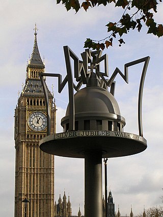
Walking is a popular recreational activity in London, despite traffic congestion. There are many streets that provide interesting walks, especially within historic central London, In addition there are attractive commons, parks, canals, and disused railway tracks that provide space for walks. This includes Wimbledon Common, Epping Forest, Hampstead Heath, and the eight Royal Parks: Hyde Park, Regent's Park, Richmond Park, etc. In recent years access to canals and rivers, including the Regent's Canal, and the River Thames has been greatly improved, and as well a number of long-distance walking routes have been created that link green spaces.

Lower Caversham is an area of the former town of Caversham, in the English county of Berkshire. Today this is itself a suburb of the larger town of Reading. Lower Caversham has no formal boundaries, but the name usually refers to that part of Caversham situated on lower ground to the east of central Caversham, close to the River Thames.

The A4074 is a British A road from the Reading suburb of Caversham to the Heyford Hill roundabout on the Oxford Ring Road.

View Island is a small island near Caversham Lock, on the River Thames at Reading, Berkshire in England.

Caversham Court is a public garden and was a mansion located on the north bank of the River Thames in Caversham, a suburb of Reading in the English county of Berkshire. The park lies within the St Peter's conservation area. The park is listed as Grade II in the National Register of Historic Parks and Gardens.
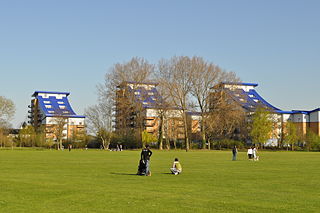
King's Meadow is a park in Reading, Berkshire, England, located next to the River Thames. It stretches from the Coal Woodland to King's Meadow Road near Reading Bridge. The Thames Path long distance footpath runs through the length of King's Meadow, which is visible from the railway when entering or leaving Reading railway station from the eastern side.

Reading's location in the Thames Valley at the confluence of the River Thames and River Kennet, and on both the Great Western Main Line and the M4 motorway, some 40 miles (64 km) west of London has made the town an important location in the nation's transport system.

Christchurch Bridge, originally known as the Reading Pedestrian and Cycle Bridge, is a pedestrian and cycle bridge over the River Thames at Reading in the English county of Berkshire. The bridge links the centre of Reading on the south bank with the cross-river suburb, and former village, of Caversham on the north bank. It crosses the river some 200 metres (660 ft) above Reading Bridge, and immediately downstream of Fry's Island.

The following is a timeline of the history of Reading, the county town of Berkshire in England.
Thames is an electoral ward of the Borough of Reading, in the English county of Berkshire. It includes areas on both sides of both the River Thames and the River Kennet, to the north and east of the centre of Reading on the south bank, and to the east of the centre of Caversham on the north bank. It should not be confused with the ward of the same name that existed prior to the 2022 Reading Borough Council election, with which it has no area in common.
Caversham Heights is an electoral ward of the Borough of Reading, in the English county of Berkshire. The ward was created by a boundary reorganisation prior to the 2022 Reading Borough Council election, and has replaced the Mapledurham ward, with the addition of parts of the old Thames and Peppard wards. During the reorganisation process, the ward was known as The Heights, but the name was subsequent changed as a result of public consultation.

Christchurch Meadows is a park in Reading, Berkshire, England, located next to the River Thames. It stretches along the north (Caversham) side of the river, between Caversham Bridge and Reading Bridge, and is linked to the south (Reading) bank by the Christchurch Bridge, a pedestrian and cycle bridge built in 2015. The name of the meadow derives from Christ Church in Oxford, whose dean owned 25 acres (10 ha) of farmland in Reading.

Thameside Promenade, or Thames Side Promenade, is a public park and promenade in Reading, Berkshire, England, located next to the River Thames. It stretches along the south (Reading) side of the river, to the west of Caversham Bridge, and forms part of the Thames Path long distance footpath. The park includes grassland behind the promenade.