Lambeth Bridge is a road traffic and footbridge crossing the River Thames in an east–west direction in central London. The river flows north at the crossing point. Downstream, the next bridge is Westminster Bridge; upstream, the next bridge is Vauxhall Bridge.

Caversham is a suburb of Reading, England, located directly north of the town centre across the River Thames. Caversham rises from the River Thames, lying on flood plain and the lowest reaches of the Chiltern Hills. Two road bridges, including Caversham Bridge, and two footbridges join Caversham to the rest of Reading. Named areas within the suburb include Emmer Green, Lower Caversham, Caversham Heights and Caversham Park Village. Notable landmarks include Caversham Court, a public park and former country house; Caversham Lakes; and part of the Thames Path national trail.

Richmond Lock and Footbridge is a lock, rising and falling low-tide barrage integrating controlled sluices and pair of pedestrian bridges on the River Thames in south west London, England and is a Grade II* listed structure. It is the furthest downstream of the forty-five Thames locks and the only one owned and operated by the Port of London Authority. It was opened in 1894 and is north-west of the centre of Richmond in a semi-urban part of south-west London. Downstream are Syon Park and Kew Gardens on opposite banks. It connects the promenade at Richmond with the neighbouring district of St. Margarets on the west bank during the day and is closed at night to pedestrians – after 19:30 GMT or after 21:30 when BST is in use. At high tide the sluice gates are raised and partly hidden behind metal arches forming twin footbridges.

Teddington Lock is a complex of three locks and a weir on the River Thames between Ham and Teddington in the London Borough of Richmond upon Thames, England. Historically in Middlesex, it was first built in 1810.

Caversham Lock is a lock and main weir on the River Thames in England at Reading, Berkshire. Both the lock and main weir are connected to De Bohun Island. The Thames Navigation Commissioners built the original lock in 1778. Additional sluices north of View Island and Heron Island form the whole weir complex. A footbridge, known as The Clappers, passes over the weir and all three islands to connect Lower Caversham to Reading.

Whitchurch Bridge is a toll bridge that carries the B471 road over the River Thames in England. It links the villages of Pangbourne in Berkshire, and Whitchurch-on-Thames in Oxfordshire – crossing the river just downstream of Whitchurch Lock. It is one of two remaining private toll bridges across the Thames, the other being Swinford Toll Bridge. The bridge has a weight limit of 7.5 tonnes and is a Grade II listed structure. Its 1792-built, now unrelated, residential toll house is also listed.
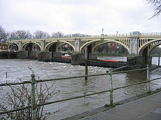
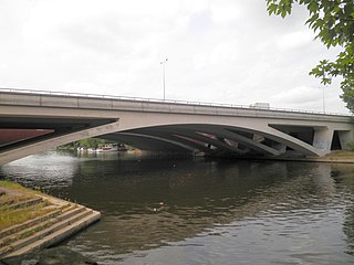
Caversham Bridge is a bridge across the River Thames between Caversham and the town centre of Reading. The bridge is situated on the reach above Caversham Lock, carrying the A4155 road across the river and also providing pedestrian access to the adjacent mid-river Pipers Island.
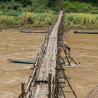
A footbridge is a bridge designed solely for pedestrians. While the primary meaning for a bridge is a structure which links "two points at a height above the ground", a footbridge can also be a lower structure, such as a boardwalk, that enables pedestrians to cross wet, fragile, or marshy land. Bridges range from stepping stones–possibly the earliest man-made structure to "bridge" water–to elaborate steel structures. Another early bridge would have been simply a fallen tree. In some cases a footbridge can be both functional and artistic.

Wandsworth Bridge crosses the River Thames in west London. It carries the A217 road between the area of Battersea, near Wandsworth Town Station, in the London Borough of Wandsworth on the south of the river, and the areas of Sands End and Parsons Green, in the London Borough of Hammersmith and Fulham, on the north side.
Barnes Railway Bridge is a Grade II listed railway bridge in the London Borough of Richmond upon Thames and the London Borough of Hounslow. It crosses the River Thames in London in a northwest to southeast direction at Barnes. It carries the South Western Railway's Hounslow Loop Line, and lies between Barnes Bridge and Chiswick stations. It can also be crossed on foot, and is one of only three bridges in London to combine pedestrian and rail use; the others being Hungerford Bridge and Golden Jubilee Bridges and Fulham Railway Bridge.

Lower Caversham is an area of the former town of Caversham, in the English county of Berkshire. Today this is itself a suburb of the larger town of Reading. Lower Caversham has no formal boundaries, but the name usually refers to that part of Caversham situated on lower ground to the east of central Caversham, close to the River Thames.
Runnymede Bridge is a motorway, A-road, pedestrian, and cycle bridge, built in the 1960s and 1980s and expanded in the 2000s, carrying the M25 and A30 across the River Thames near the uppermost end of the Staines upon Thames and Egham reach of the river. It is oriented north–south and is southwest of Heathrow Airport. It consists of Runnymede Bridge and New Runnymede Bridge; commonly referred to as one bridge.

Reading's location in the Thames Valley at the confluence of the River Thames and River Kennet, and on both the Great Western Main Line and the M4 motorway, some 40 miles (64 km) west of London has made the town an important location in the nation's transport system.

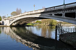
Christchurch Bridge, originally known as the Reading Pedestrian and Cycle Bridge, is a pedestrian and cycle bridge over the River Thames at Reading in the English county of Berkshire. The bridge links the centre of Reading on the south bank with the cross-river suburb, and former village, of Caversham on the north bank. It crosses the river some 200 metres (660 ft) above Reading Bridge, and immediately downstream of Fry's Island.

The following is a timeline of the history of Reading, the county town of Berkshire in England.

St Peter's Bridge carries the A5189 road across the River Trent in Burton upon Trent, Staffordshire, England. Opened in 1985, the 800-metre (2,600 ft) long reinforced concrete bridge is the most recent road crossing of the Trent. It was closed for more than two months in 2017 for major repair works.

Dukes Meadows Footbridge is a pedestrian bridge beside the River Thames in Chiswick in West London. Opened in 2023, it allows the Thames Path on the north bank at Dukes Meadows to follow the river without diversion.
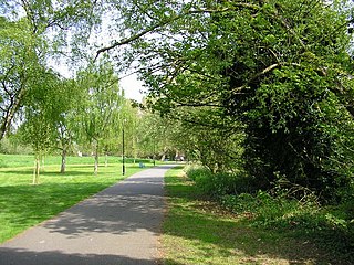
Hills Meadow is a park in Reading, Berkshire, England, located next to the River Thames. It stretches along the north (Caversham) side of the river, to the east of Reading Bridge. It is linked to the south (Reading) bank by a footpath, locally known as The Clappers that crosses View Island and the weir at Caversham Lock.