The Himalayan Towers, also called Stone star-shaped towers, are stone tower houses built for defensive purpose[citation needed], found mostly in Kham, a region of Tibet, as well as in the area inhabited by the modern Qiang people and in the historical region inhabited by the Tanguts.
These towers can be found both in cities and in uninhabited regions. They were described for the first time during the Ming dynasty (1368-1644). Carbon dating by Frederique Darragon shows they were built approximately 500-1800 years ago.[citation needed] Since they are generally located in prosperous villages, it is believed that their primary function was that of a demonstration of a family's prestige within the community. At that time, wealth was acquired especially by the trade with the Mongols. For strength, many of the towers use a star pattern of walls as opposed to a strictly rectangular method. Their heights can exceed 60 meters (200ft).[1]
The towers were listed by World Monuments Fund in the endangered cultural sites list of the 2006 World Monuments Watch. The towers were unknown to mainstream cultural experts in China prior to its enlistment as an endangered site. The World Monument Fund has allocated resources to repair and conserve some of the towers which have been vandalized or neglected through time. Locals have been pushing for the declaration of the towers and its landscape to be part of the UNESCOWorld Heritage List.[2]
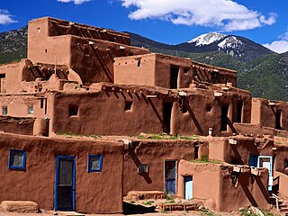
Taos Pueblo is an ancient pueblo belonging to a Taos-speaking (Tiwa) Native American tribe of Puebloan people. It lies about 1 mile (1.6 km) north of the modern city of Taos, New Mexico. The pueblos are one of the oldest continuously inhabited communities in the United States. This has been designated a UNESCO World Heritage Site.
Bamyan Province, also spelled Bamiyan, Bāmīān or Bāmyān, is one of the thirty-four provinces of Afghanistan with the city of Bamyan as its center, located in central parts of Afghanistan.
Minar-e-Pakistan is a tower located in Lahore, Punjab, Pakistan. The tower was built between 1960 and 1968 on the site where the All-India Muslim League passed the Lahore Resolution on 23 March 1940 - the first official call for a separate and independent homeland for the Muslims of British India, as espoused by the two-nation theory. The resolution eventually helped lead to the creation of Pakistan in 1947.
Kilwa Kisiwani is an island, national historic site, and hamlet community located in the township of Kilwa Masoko, the district seat of Kilwa District in the Tanzanian region of Lindi Region in southern Tanzania. Kilwa Kisiwani is the largest of the nine hamlets in the town Kilwa Masoko and is also the least populated hamlet in the township with fewer than 1,000 residents.
The Minaret of Jam is a UNESCO World Heritage Site in western Afghanistan. It is located in a remote and nearly inaccessible region of the Shahrak District, Ghor Province, next to the Hari River. The 62 m (203 ft) or 65 m (213 ft) high minaret was built c. 1190 entirely of baked bricks and is famous for its intricate brick, stucco and glazed tile decoration, which consists of alternating bands of kufic and naskhi calligraphy, geometric patterns, and verses from the Qur'an. Since 2002, the minaret has remained on the list of World Heritage in Danger, under serious threat of erosion, and has not been actively preserved. In 2014, the BBC reported that the tower was in imminent danger of collapse.
The Rice Terraces of the Philippine Cordilleras are a World Heritage Site consisting of a complex of rice terraces on the island of Luzon in the Philippines. They were inscribed on the UNESCO World Heritage List in 1995, the first-ever property to be included in the cultural landscape category of the World Heritage List. This inscription has five sites: the Batad Rice Terraces and Bangaan Rice Terraces, Mayoyao Rice Terraces, Hungduan Rice Terraces and Nagacadan Rice Terraces, all in Ifugao Province. The Ifugao Rice Terraces reach a higher altitude and were built on steeper slopes than many other terraces. The Ifugao complex of stone or mud walls and the careful carving of the natural contours of hills and mountains combine to make terraced pond fields, coupled with the development of intricate irrigation systems, harvesting water from the forests of the mountain tops, and an elaborate farming system.
Champaner-Pavagadh Archaeological Park, a UNESCO World Heritage Site, is located in Panchmahal district in Gujarat, India. It is located around the historical city of Champaner, a city which was founded by Vanraj Chavda, the most prominent king of the Chavda Dynasty, in the eighth century. He named it after the name of his friend and general Champa, also known later as Champaraj. The heritage site is studded with forts with bastions starting from the hills of Pavagadh, and extending into the city of Champaner. The park's landscape includes archaeological, historic and living cultural heritage monuments such as chalcolithic sites, a hill fortress of an early Hindu capital, and remains of the 16th-century capital of the state of Gujarat. There are palaces, entrance gates and arches, mosques, tombs and temples, residential complexes, agricultural structures and water installations such as stepwells and tanks, dating from the eighth to the 14th centuries. The Kalika Mata Temple, located on top of the 800 metres (2,600 ft) high Pavagadh Hill, is an important Hindu shrine in the region, attracting large numbers of pilgrims throughout the year.
Frederique Darragon is a French explorer known for her documentary film The Secret Towers of the Himalayas, which chronicled her expedition to the mystifying stone towers of Sichuan and Tibet. She wrote a book also titled The Secret Towers of the Himalayas. She is founder and president of the Unicorn Foundation, to which profits from the film were contributed. She is the co-founder of the Sichuan University Unicorn Heritage Institute.
The white-bellied musk deer or Himalayan musk deer is a musk deer species occurring in the Himalayas of Nepal, Bhutan, India, Pakistan and China. It is listed as endangered on the IUCN Red List because of overexploitation resulting in a probable serious population decline.
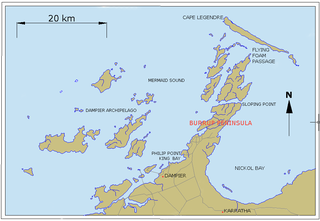
Murujuga, formerly known as Dampier Island and today usually known as the Burrup Peninsula, is an area in the Dampier Archipelago, in the Pilbara region of Western Australia, containing the town of Dampier. The Dampier Rock Art Precinct, which covers the entire archipelago, is the subject of ongoing political debate due to historical and proposed industrial development. Over 40% of Murujuga lies within Murujuga National Park, which contains within it the world's largest collection of ancient 40,000 year old rock art (petroglyphs).
The Lednice–Valtice Cultural Landscape is a cultural-natural landscape complex of 283.09 square kilometres (109.30 sq mi) in the South Moravian Region of the Czech Republic. It comprises the municipalities of Lednice, Valtice and Hlohovec, and the rural area of Břeclav.
Architecture of Tibet contains Chinese and Indian influences but has many unique features brought about by its adaptation to the cold, generally arid, high-altitude climate of the Tibetan plateau. Buildings are generally made from locally available construction materials, and are often embellished with symbols of Tibetan Buddhism. For example, private homes often have Buddhist prayer flags flying from the rooftop.
Bewcastle Roman Fort was built to the north of Hadrian's Wall as an outpost fort possibly intended for scouting and intelligence. The remains of the fort are situated at the village of Bewcastle, Cumbria, 7 miles (11 km) to the north of the Roman fort at Birdoswald, on Hadrian's Wall.
The World Monuments Watch is a flagship advocacy program of the New York-based private non-profit organization World Monuments Fund (WMF) that is dedicated to preserving the historic, artistic, and architectural heritage around the world.
The LINGUIST List is an online resource for the academic field of linguistics. It was founded by Anthony Aristar in early 1990 at the University of Western Australia, and is used as a reference by the National Science Foundation in the United States. Its main and oldest feature is the premoderated electronic mailing list, with subscribers all over the world.
The Edison State Park is located in the Menlo Park section of Edison, New Jersey. It is located on Christie Street, the first street in the world to be lit up by lightbulb, just off Lincoln Highway, near the Metropark Train Station. It covers a total area of 37 acres (0.15 km2). The park commemorates the site where the famous inventor Thomas Alva Edison had his Menlo Park laboratory. In his laboratory, Edison invented over 600 inventions such as the incandescent electric light and the phonograph, the latter being the first object to record and play sound.
Thimlich Ohinga is a complex of stone-built ruins in Migori county, Nyanza Kenya, in East Africa. It is the largest one of 138 sites containing 521 stone structures that were built around the Lake Victoria region in Kenya. These sites are highly clustered. The main enclosure of Thimlich Ohinga has walls that are 1–3 m (3.3–9.8 ft) in thickness, and 1–4.2 m (3.3–13.8 ft) in height. The structures were built from undressed blocks, rocks, and stones set in place without mortar. The densely packed stones interlock. The site is believed to date to the 15th century or earlier.
The Fortifications of Diyarbakır are a set of fortifications enclosing the historical district of Sur in Diyarbakır, Turkey. They consist of an inner fortress, the citadel, and an outer ring of city walls.
The Lucano bridge is a Roman stone bridge over the Aniene river in the Province of Rome, Italy, on the via Tiburtina. Coming from the direction of Rome, the bridge is found after Tivoli Terme and before Hadrian's Villa. This bridge was part of the project for the most endangered monuments of the World Monuments Fund for the year 2010.
This page is based on this Wikipedia article Text is available under the CC BY-SA 4.0 license; additional terms may apply. Images, videos and audio are available under their respective licenses.