
Mewstone is an unpopulated island, composed of muscovite granite, located close to the south coast of Tasmania, Australia. The 13.1-hectare (32-acre) island has steep cliffs and a small flat summit and is part of the Pedra Branca group, lying 12 kilometres (7.5 mi) southeast of Maatsuyker Island, and 22 kilometres (14 mi) off the south coast of Tasmania. Mewstone comprises part of the Southwest National Park and the Tasmanian Wilderness World Heritage Site.
The Oyster Rocks are a close pair of small granite islands, with a combined area of about 6 ha, in south-eastern Australia. They are part of Tasmania’s Tin Kettle Island Group, lying in eastern Bass Strait between Flinders and Cape Barren Islands in the Furneaux Group. They are a conservation area. The islands are part of the Franklin Sound Islands Important Bird Area, identified as such by BirdLife International because it holds over 1% of the world populations of six bird species.
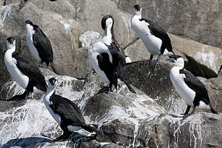
Egg Island is a small island, with an area of 0.83 ha, in south-eastern Australia. It is part of the North Coast Group, lying in Bass Strait on Horseshoe Reef near Devonport in north-west Tasmania. It has been identified as an Important Bird Area (IBA) because of its globally significant colony of black-faced cormorants. Wright Island is nearby.

The Passage Island, part of the Passage Group within the Furneaux Group, is a 253-hectare (630-acre) granite and dolerite island, located in Bass Strait south of Cape Barren Island, in Tasmania, in south-eastern Australia.

Night Island is a small granite island, with an area of 2.59 ha, is part of the Preservation Island Group, lying in eastern Bass Strait south of Cape Barren Island in the Furneaux Group, Tasmania, Australia.

The Big Black Reef, part of the Long Island Group within the Furneaux Group, is a 0.54-hectare (1.3-acre) unpopulated small, flat dolerite island, located in Bass Strait, lying west of Cape Barren Island, Tasmania, in south-eastern Australia.
Boxen Island is a flat dolerite island, with an area of 7 ha, in south-eastern Australia. It is part of Tasmania’s Long Island Group, lying in eastern Bass Strait west of Cape Barren Island in the Furneaux Group. Together with nearby Big Black Reef it is classified by BirdLife International as an Important Bird Area because it has been recorded as supporting 288 breeding pairs of black-faced cormorants.
The Little Badger Island, part of the Badger Group within the Furneaux Group, is a 2.5-hectare (6.2-acre) unpopulated low-lying granite island, located in Bass Strait, lying west of the Flinders and Cape Barren islands, Tasmania, south of Victoria, in south-eastern Australia.
The Little Goose Island, part of the Badger Group within the Furneaux Group, is a 3.6-hectare (8.9-acre) unpopulated flat, round granite island, located in Bass Strait, lying west of the Flinders and Cape Barren islands, Tasmania, south of Victoria, in south-eastern Australia. The island is contained within a nature reserve and is part of the Chalky, Big Green and Badger Island Groups Important Bird Area.
The Ninth Island, officially Tareerpattel-tarerenner / Ninth Island, is a 32-hectare (79-acre) uninhabited granite island situated in Bass Strait as part of the Waterhouse Island Group, lying close to the north-eastern coast of Tasmania, Australia. In November 2018, it was listed for sale for the fourth time, at $1.98 million. The property for sale is a landlocked title within a conservation covenant, preventing access to the island by any means except helicopter.
The Little Waterhouse Island, part of the Waterhouse Island Group, is a 2.5-hectare (6.2-acre) granite island situated in Banks Strait, part of Bass Strait, lying close to the north-eastern coast of Tasmania, Australia.
The George Rocks, also historically known as King George's Rocks, is part of the Waterhouse Island Group, a group of three adjacent uninhabited granite islets and associated reefs with a combined area of 7 hectares, situated in Banks Strait, part of Bass Strait, lying close to the north-eastern coast of Tasmania, Australia.

The St Helens Island, part of the Waterhouse Island Group, is a 51-hectare (130-acre) granite island situated in the Tasman Sea, lying close to the north-eastern coast of Tasmania, Australia.

The Nuggets is a close group of four granite islets, with a combined area of 6.76 hectares, in south-eastern Australia. They lie close to the eastern coast of Tasmania near the Freycinet Peninsula., and are near Cape Tourville, about 7 km north of Wineglass Bay and about 22 km north of Schouten Island.

The Thumbs is a small and jagged island, with three prominent spires and an area of 4,500 square metres, in south-eastern Australia. It is part of the Tasman Island Group, lying close to the south-eastern coast of Tasmania around the Tasman Peninsula, and is in the Tasman National Park.

The Tasman Island, part of the Tasman Island Group, is an oval island with an area of 1.2 square kilometres (0.46 sq mi), lying close to the south-eastern coast of Tasmania, Australia. The island is located in the Tasman Sea, situated off the Tasman Peninsula and is contained within the Tasman National Park.

Betsey Island, along with the adjacent Little Betsey Island and Betsey Reef, forms a nature reserve with an area of 176 ha in south-eastern Australia. They are part of the Betsey Island Group, lying close to the south-eastern coast of Tasmania around the entrance to the River Derwent. It is classified as an Important Bird Area by BirdLife International; it is an important site for little penguins with an estimated 15,000 pairs breeding there, short-tailed shearwaters, and black-faced cormorants.
The Mackerel Islets are two small islands in south-eastern Australia. They are part of the Tasman Island Group, lying close to the south-eastern coast of Tasmania around the Tasman Peninsula.
The Franklin Sound Islands Important Bird Area comprises several small islands, with a collective total area of 1725 ha, lying in Franklin Sound between the much larger Flinders Island to the north and Cape Barren Island to the south, in the Furneaux Group of Tasmania, Australia.

St Helens Important Bird Area comprises four separate sites, with a collective total area of 24 km2, in the vicinity of the town of St Helens on the northern part of the east coast of Tasmania, south-eastern Australia.


