
The Aija Province is one of 20 provinces of the Ancash Region in Peru.

Antonio Raymondi is a province of the Ancash Region in Peru. It is located along the central eastern edge of the Ancash Region, bordering the Huánuco Region.

The Cajatambo Province is one of nine provinces in the Lima Region of Peru. It is bordered to the north by the Ancash Region, to the east by the Huánuco Region, to the south by the Oyón Province, and to the west by the Huaura Province.

The Bolognesi Province is one of 20 provinces of the Ancash Region of Peru.
Huallanca or Wallanka is a district of the Bolognesi Province in the Ancash Region of Peru.

The Dos de Mayo Province is one of eleven provinces of the Huánuco Region in Peru. The capital of this province is the city of La Unión.

Oyón Province is a province of the Lima Region in Peru. It measures 1,886 square kilometres (728 sq mi). The capital of the province is the city of Oyón.
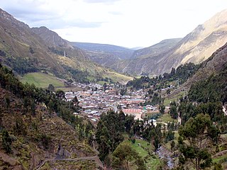
Cochamarca is one of six districts of the Oyón Province in Peru.

Oyón District is one of six districts of the province Oyón in Peru.
Huamantanga is one of seven districts of the Canta Province in Peru.
Pumaq Hirka is an archaeological site in Peru. It is situated in the Huánuco Region, Huamalíes Province, Miraflores District, at a height of about 3,696 metres (12,126 ft).
Warahirka or Wara Hirka is a mountain with an archaeological site of the same name in Peru. It is situated in the Huánuco Region, Yarowilca Province, Pampamarca District, about 1.5 km from Pampamarca, near La Florida and Warahirka (Huarajirca).

Condor Huayin is a mountain in the Andes of Peru, about 5,000 metres (16,404 ft) high. It is situated in the Lima Region, Oyon Province, Oyon District. Condor Huayin lies on a ridge which extends from north to south southeast of the Huayhuash mountain range and southwest of the Raura mountain range. The peak south of Condor Huayin at the very end of the ridge is named Shapra.
Waylla Hirka is a mountain in the Andes of Peru, about 4,800 metres (15,748 ft) high. It is located in the Lima Region, Cajatambo Province, Cajatambo District. Waylla Hirka lies at the Pumarinri valley south of the Waywash mountain range, southwest of Pukaqaqa and north of Millpu. The lakes Quyllurqucha, Warmiqucha and Challwaqucha lie northeast of Waylla Hirka.
Huayllajirca is a mountain in the Andes of Peru, about 5,000 m (16,000 ft) high. It is located in the Lima Region, Cajatambo Province, Cajatambo District, and in the Oyón Province, Oyón District. Huayllajirca lies northwest of the mountain named Chalhuacocha and northeast of Pishtac and Tocto lake.
Pishtac (possibly from Ancash Quechua for slaughterer, is a 5,095-metre-high mountain in the Andes of Peru. It is located in the Lima Region, Cajatambo Province, Cajatambo District. Pishtac is southwest of Huayllajirca and northwest of a mountain called Chalhuacocha. A little lake named Tocto lies at its feet.
Mishihuajanan is a mountain in the Andes of Peru, about 5,100 m (16,700 ft) high. It is located in the Lima Region, Cajatambo Province, Cajatambo District, and in the Oyón Province, Oyón District. Mishihuajanan lies southwest of Millpo and north of Huayllajirca.
Yanajirca or Yana Hirka is a mountain in the Andes of Peru, about 4,600 m (15,100 ft) high. It is located in the Lima Region, Cajatambo Province, Cajatambo District. Yana Hirka is southwest of Mishi Waqanan and northwest of Pishtaq.
Pirwa Hirka is a mountain in the Andes of Peru, about 4,800 m (15,700 ft) high. It is located in the Lima Region, Huaral Province, Pacaraos District, and in the Pasco Region, Pasco Province, Huayllay District. It lies west of a lake named Warunqucha.
Puka Hirka is a mountain in the Andes of Peru which reaches a height of approximately 4,000 m (13,000 ft). It is located in the Huánuco Region, Dos de Mayo Province, Marías District. Puka Hirka lies northeast of Saqra Waqra.


