History of Partick

Last updated

This article deals with the history of the Partick area of Glasgow in Scotland.

Contents

Etymology of Partick

The place name Partick is derived from the Cumbric word for 'thicket'. This etymology reflects the fact that the inhabitants of the Glasgow/Strathclyde region were speakers of this Old Welsh dialect. Gaelic only became of predominant in this area with the waning and disappearance of the British Kingdom of Alt Clut/Strathclyde, perhaps in the eleventh century.[ citation needed ]

Dark Ages Royal centre

There is some evidence that Partick was an important centre for the Kings of Alt Clut/Strathclyde. According to the Cistercian monk and hagiographer of St Kentigern, Jocelin of Furness, King Rhydderch had a residence in 'Pertnech' (Partick). Some archaeologists have deduced that the royal Partick estate was part of a larger elite centre of the kingdom, which included the ecclesiastical establishment just across the River Clyde at Govan. [1] Partick and Govan may have come to prominence as a political centre following the Vikings' sack of Dumbarton in 870. [2] The lands of Partick remained royal property until King David granted them to the Bishops of Glasgow on the cathedral's dedication to Saint Kentigern, along with the lands of Govan. [3]

Bishop's Residence

Coat of arms of the Burgh of Partick, showing the castle and mitre of the Bishop of Glasgow Coat of Arms of Partick.svg
Coat of arms of the Burgh of Partick, showing the castle and mitre of the Bishop of Glasgow

From the time of King David's grant of land to the Bishops of Glasgow, the country residence of the Bishops was situated in Partick. This is supported by the existence of a deed of 1277 in which Maurice, Lord of Luss made a contract at Perthec for the sale of timber to the authorities at Glasgow Cathedral. [4]

The Bishops' residence is depicted on the former Burgh of Partick's coat of arms as a castle. In 1362, a settlement of a dispute between the Bishop and his chapter house was made at his manor-house of Perthic. [5] Glasgow's Bishops continued to use their residence in Partick until the reformation in 1560, when Bishop James Beaton II fled to France from there, taking with him the sacred relics from Glasgow Cathedral. [6]

The Reformation and after

After the reformation in 1560, ownership of the lands returned to the Scottish Crown. From that time on to the nineteenth century, Partick was part of Govan parish and therefore in Renfrewshire. The boundary between Glasgow and Partick was the River Kelvin (but with a small area over the river at Pointhouse also in Partick). [7]

Partick was the main crossing point of the River Kelvin for the road between Glasgow and Dumbarton. From earliest times, the river was crossed by a ford. Later came a wooden bridge for foot passengers. It is commonly thought that the first permanent stone bridge over the river was built by Captain Thomas Crawford of Jordanhill, who was Provost of Glasgow at the start of the seventeenth century.

The building known as Partick Castle lay close to Partick's original ford. It was built by the Glasgow benefactor, George Hutcheson, and was derelict by the late eighteenth century.

Milling Centre

Partick remained a relatively small village until the early nineteenth century. The steep drop of the River Kelvin between what is now Glasgow's Botanic Gardens and the river's mouth, led to Partick becoming an important centre of milling, especially grain milling. While Glasgow's Molendinar Burn powered a few mills during the medieval period, its flow was insufficient for the needs of the growing burgh, perhaps as early as the twelfth century. [8] So the city came to depend on the rapidly flowing River Kelvin for its milling as well as two other locations: Bedlay (Cadder) and Clydesmill (Carmyle). [9]

Records of Partick as a milling centre go back to the Middle Ages. A prophecy of Thomas the Rhymer (thirteenth century) predicts:

'you may walk across the Clyde on men's bodies, and the miller of Partick Mill (muileann Pearraig), who is to be a man with seven fingers will grind for two hours with blood instead of water.' [10]

Before the reformation, the inhabitants of Glasgow used to grind their grain at either the Town Mill of Partick or at a nearby small mill belonging to Glasgow's Archbishop.

By 1820, Partick was a major milling centre, with several located in its vicinity. These included: the Old Mill (on the site of the building now known as the Bishop's Mill), the Slit Mill, the Archbishop's Mill (later Bunhouse/Regent Mill), the Waulk Mill (now Scotstoun Mill) and the Wee Mill. [11] A little way upstream of Partick, there was also Clayslaps Mill (just below what is now Kelvingrove Museum & Art Gallery). Such a concentration of mills eventually resulted in the Clyde Navigation Trust building its colossal granaries at Meadowside in Partick in 19111913 (with subsequent extensions in 1936, 1960 and 1967). [12] These were demolished in 2004 to make way for the Glasgow Harbour residential development

Of Partick's mills, Scotstoun Mill in Dunaskin Street, owned by Rank Hovis MacDougall, was the last to remain in operation. It closed in 2013.

Nineteenth Century Development

During the nineteenth century Partick developed from a small village into a relatively populous centre as a result of the fast pace of industrial development along the River Clyde and improving communications. The table [13] below summarises the population of the Burgh of Partick during the nineteenth century:

YearPopulation
18201,235
18341,842
18413,184
18515,043
186110,917
187117,707
188127,410
189136,538
190154,274
191166,848

The development of the Clydeside ship building industry, in particular, gave momentum to Partick's rapid expansion. This in turn was made possible by the steady canalisation of the River Clyde between 1773 and the 1830s, which deepened and narrowed the river, to make it navigable by large ships. Canalisation also created 'firmer' banks along great stretches of the River Clyde, enhancing the prospect of their industrial development. In 1844 Messrs David Tod & John McGregor moved their shipbuilding operation from Govan to Partick. In 1858 a major step for their enterprise, was the opening of a new graving dock at their Meadowside site. Subsequently, several other shipyards opened along the north bank of the Clyde, including one directly across the mouth of the River Kelvin at Pointhouse (in 1845). Further west along the River Clyde, Barclay Curle's shipyard opened in 1855, precipitating the rapid development of the Whiteinch area. This was followed by the opening of Connell's shipyard (1861) and the Yarrow shipyard (1906) both yet further west in Scotstoun. [14]

The transport of people and goods along the north bank of the River Clyde (between residential and industrial areas) was facilitated by the construction of the Lanarkshire and Dunbartonshire Railway, which opened in stages between 1894 and 1896.

A Police Burgh

The Police of Towns (Scotland) Act, 1850 (Lock's Act) made it easier for Police Burghs to be created. Any "populous place" from this time on was able to adopt a police system and become a burgh.

The pressures caused by Partick's very rapid demographic and industrial expansion proved to be too much for the village's mid-nineteenth century infrastructure. In June 1852, at a public meeting, the householders of Partick agreed to constitute themselves into a Police Burgh to remedy a range of common concerns including:

...the defective state of the drainage, the disrepair of the streets and roads, the number and increase of nuisances in the locality, and the inability of the inhabitants to either to compel a proper and efficient system of drainage or to control or abate any nuisance, or to make any sanitary or other regulations for the well being of the community... [15]

Twelve householders were elected as Commissioners. From among them, the shipbuilder David Tod was elected Partick's first Provost. According to the contemporary local historian, James Napier, these Commissioners (including himself) acted immediately:

The Commissioners now began to carry out a system of drainage and other sanitary measure with considerable promptitude, and, as the following facts show to great advantage. The first three years after 1854, the average death rate was 34.5 per 1000 of the population; the average of the last three years (he was writing in 1875), including 1872, is 21 per 1000 of the population, showing a saving of many hundred of lives to the community. [16]

By 1853, the Commissioners had built a small administrative building for the Burgh in a palazzo style. This eventually became Partick's police building which can still seen in Anderson Street (though Partick's Police Station has now been moved to the Thornwood stretch of Dumbarton Road). In 1872, the larger Partick Burgh Hall was built (in a Francois I style) to a design by William Leiper. [17]

In 1912, the Burgh of Partick ceased to exist having been incorporated into the ever-expanding Glasgow Corporation. A contemporary account relates:

While the Burgh Organist played "Lochaber no More", the Provost's chain of office was removed from his neck, and as his robe was laid aside the Provost said, "There they lie, the abandoned habits of the Provost of Partick, taken from him by Act of Parliament. [18] "

List of Provosts of Partick

Partick's last Provost was born in Markinch, Fife on 8 January 1855 to Robert Brown and Mary Stark; the 4th of 7 children.

Related Research Articles

<span class="mw-page-title-main">River Clyde</span> River in Scotland

The River Clyde is a river that flows into the Firth of Clyde in Scotland. It is the ninth-longest river in the United Kingdom, and the second-longest in Scotland. It runs through the major city of Glasgow. Historically, it was important to the British Empire because of its role in shipbuilding and trade. To the Romans, it was Clota, and in the early medieval Cumbric language, it was known as Clud or Clut. It was central to the Kingdom of Strathclyde.

<span class="mw-page-title-main">Glasgow</span> Largest city in Scotland

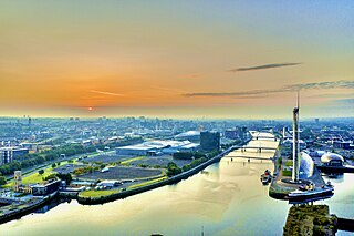
Glasgow is the most populous city in Scotland, and is the third-most populous city in the United Kingdom, as well as being the 27th largest city by population in Europe. In 2022, it had an estimated population as a defined locality of 632,350 and anchored an urban settlement of 1,028,220. Formed as a county of itself in 1893, the city had previously been in the historic county of Lanarkshire and has also grown to include settlements that were once part of Renfrewshire and Dunbartonshire. It now forms the Glasgow City Council area, one of the 32 council areas of Scotland, and is administered by Glasgow City Council.

<span class="mw-page-title-main">Glasgow City Council</span> Scottish unitary authority council in Glasgow, Scotland

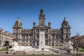
Glasgow City Council is the local government authority for Glasgow City council area, Scotland. In its modern form it was created in 1996. Glasgow was formerly governed by a corporation, also known as the town council, from the granting of its first burgh charter in the 1170s until 1975. From 1975 until 1996 the city was governed by City of Glasgow District Council, a lower-tier authority within the Strathclyde region.

<span class="mw-page-title-main">Partick</span> Area of Glasgow, Scotland

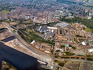
Partick is an area of Glasgow on the north bank of the River Clyde, just across from Govan. To the west lies Whiteinch, to the east Yorkhill and Kelvingrove Park, and to the north Broomhill, Hyndland, Dowanhill, Hillhead, areas which form part of the West End of Glasgow. Partick was a Police burgh from 1852 until 1912 when it was incorporated into the city. Partick is the area of the city most connected with the Highlands, and several Gaelic agencies, such as the Gaelic Books Council are located in the area. Some ATMs in the area display Gaelic.

<span class="mw-page-title-main">Govan</span> Area of Glasgow, Scotland

Govan is a district, parish, and former burgh now part of south-west Glasgow, Scotland. It is situated 2.5 miles (4.0 km) west of Glasgow city centre, on the south bank of the River Clyde, opposite the mouth of the River Kelvin and the district of Partick. Historically it was part of the County of Lanark.

<span class="mw-page-title-main">Clydebank</span> Town in Scotland

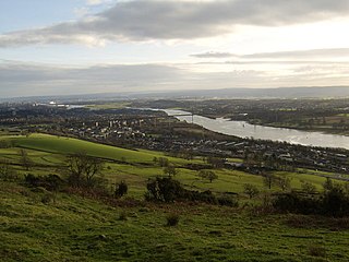
Clydebank is a town in West Dunbartonshire, Scotland. Situated on the north bank of the River Clyde, it borders the village of Old Kilpatrick to the west, and the Yoker and Drumchapel areas of the adjacent City of Glasgow immediately to the east. Depending on the definition of the town's boundaries, the suburban areas of Duntocher, Faifley and Hardgate either surround Clydebank to the north, or are its northern outskirts, with the Kilpatrick Hills beyond.

<span class="mw-page-title-main">Scotstoun</span> Human settlement in Scotland

Scotstoun is an area of Glasgow, Scotland, west of Glasgow City Centre. It is bounded by Garscadden and Yoker to the west, Victoria Park, Jordanhill and Whiteinch to the east, Jordanhill to the north and the River Clyde to the south. At the heart of Scotstoun lies Scotstounhill, an enclave of late Victorian and post-war housing centred on Scotstounhill railway station. Scotstoun is home to BAE Systems Surface Ships, and to the Glasgow Warriors rugby team.

<span class="mw-page-title-main">City of Glasgow Police</span> Former police force of Glasgow, Scotland

The City of Glasgow Police or Glasgow City Police was the police covering the city and royal burgh of Glasgow, from 1800 to 1893, and the county of city of Glasgow, from 1893 to 1975. In the 17th century, Scottish cities used to hire watchmen to guard the streets at night, augmenting a force of unpaid citizen constables. On 30 June 1800 the authorities of Glasgow successfully petitioned the British Government to pass the Glasgow Police Act establishing the City of Glasgow Police. It served Glasgow from 1800 to 1975, when it was amalgamated into Strathclyde Police.

<span class="mw-page-title-main">History of Glasgow</span> Aspect of history

This article deals with the history of the city of Glasgow, Scotland.

<span class="mw-page-title-main">Yorkhill</span> Human settlement in Scotland

Yorkhill is an area in the city of Glasgow, Scotland. It is situated north of the River Clyde in the West End of the city. It is known for its famous hospitals and remains the location of the West Glasgow Ambulatory Care Hospital.

<span class="mw-page-title-main">Whiteinch</span> Human settlement in Scotland

Whiteinch is an area in the city of Glasgow, Scotland. It is situated directly north of the River Clyde, between the Partick and Scotstoun areas of the city. Whiteinch was at one stage part of the burgh of Partick, until that burgh's absorption into the expanding city of Glasgow in 1912, and part of the Parish of Govan.

<span class="mw-page-title-main">Glasgow Harbour</span>

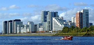
Glasgow Harbour in the following paragraphs is about a private sector urban regeneration scheme at Partick in the West End of the city of Glasgow, Scotland. It is not the history and development of the wider and internationally famous Glasgow Harbour from Glasgow Green to Clydebank which developed from the early 1800s and witnessed the birth and growth of modern shipbuilding and shipping.

<span class="mw-page-title-main">Renfrewshire (historic)</span> Historic county and lieutenancy area of western Scotland

Renfrewshire or the County of Renfrew is a historic county, registration county and lieutenancy area in the west central Lowlands of Scotland. The lieutenancy area covers the three modern council areas of Inverclyde, Renfrewshire and East Renfrewshire, and this area is occasionally termed Greater Renfrewshire to distinguish it from the modern council area called Renfrewshire. The historic county additionally included territory on the south-western edge of Glasgow which was gradually transferred to the administrative area of the city as it grew.

John Macgregor (1802–1858) was a Scottish shipbuilder.

<span class="mw-page-title-main">Riverside Museum</span> Transport museum in Glasgow, Scotland.

The Riverside Museum is a museum in the Yorkhill area of Glasgow, Scotland, housed in a building designed by Zaha Hadid Architects, with its River Clyde frontage at the new Pointhouse Quay. It forms part of the Glasgow Harbour regeneration project. The building opened in June 2011, winning the 2013 European Museum of the Year Award. It houses many exhibits of national and international importance. The Govan-Partick Bridge, which will provide a pedestrian and cycle path link from the museum across the Clyde to Govan, is set to be completed in 2024.

<span class="mw-page-title-main">Partick Castle</span>

Partick Castle was located in Partick, now a Western suburb of Glasgow. It was built in 1611 for the Glasgow benefactor George Hutcheson and situated on the west bank of the River Kelvin.

<span class="mw-page-title-main">Glasgow parliamentary constituencies</span>

The city of Glasgow, located in Scotland, UK, is represented in both the Westminster Parliament in London, and the Scottish Parliament in Holyrood, Edinburgh. At Westminster, it is represented by seven Members of Parliament (MPs), all elected to represent individual constituencies at least once every five years, using the first-past-the-post system of voting. In Holyrood, Glasgow is represented by sixteen MSPs, nine of whom are elected to represent individual constituencies once every five years using first-past-the-post, and seven of whom are elected as additional members, through proportional representation.

The politics of Glasgow, Scotland's largest city by population, are expressed in the deliberations and decisions of Glasgow City Council, in elections to the council, the Scottish Parliament and the UK Parliament.

<span class="mw-page-title-main">Kelvinhaugh, Glasgow</span> Human settlement in Scotland

Kelvinhaugh is a neighbourhood in the city of Glasgow, Scotland. It is situated directly north of the River Clyde in the West End of the city.

White Inch was an island lying in the estuarine waters of the River Clyde close to Glasgow in the Parish of Govan, Lanarkshire, Scotland. Due to the deliberate disposal of dredged material from the Clyde, it became physically part of the northern, Lanarkshire side, of the river bank from the 1830s and is now entirely built over. The name lives on in the Whiteinch district of Glasgow, street names, etc., and probably relates to white colored sand deposits.

References

  1. Driscoll, Stephen (September 1997). "Kingdom of Strathclyde's final chapter'". British Archaeology. Retrieved 27 September 2008.
  2. Driscoll, Stephen (2002) Alba, The Gaelic Kingdom of Scotland AD 800-1124, p. 26.
  3. Macquarrie, Alan (1993) The Kings of Strathclyde, c.400-1018 pp. 1-19 in Medieval Scotland: Government, Lordship and Community: Studies Presented to G.W.S. Barrow. Edited by A. Grant and K.J. Stringer.
  4. Greenhorne, William (1928) History of Partick 550-1912 p. 10.
  5. Napier, James (1873) Notes And Reminiscences Relating To Partick p. 21.
  6. Greenhorne, William (1928) History of Partick 550-1912 p. 11.
  7. Matheson, Alex (2000) Glasgow's Other River: Exploring the Kelvin p. 194.
  8. Hume, John (1974) The Industrial Archaeology of Glasgow, p. 4.
  9. Nisbet, Stuart (2008) The Old Mill of Partick FORK Newsletter Spring 2008, p. 6.
  10. Campbell, John Gregorson (1900) Superstitions of the Highlands & Islands of Scotland.
  11. Napier James,(1873) Partick in 1820 (Map in frontispiece to 'Notes And Reminiscences Relating To Partick').
  12. Williamson, Elizabeth et al. (1990) Glasgow in The Buildings of Scotland series, pp. 374-375.
  13. Greenhorne, William (1928) History of Partick 550-1912, p. 154.
  14. Hume, John (1974) The Industrial Archaeology of Glasgow pp. 82-83.
  15. Greenhorne, William (1928) History of Partick 550-1912, pp. 137-138.
  16. Napier, James (1873) Notes And Reminiscences Relating To Partick, p. 126.
  17. Williamson, Elizabeth et al. (1990) Glasgow in The Buildings of Scotland series, p. 372.
  18. Greenhorne, William (1928) History of Partick 550-1912, p. 155.