History of Valledupar

Last updated

The History of Valledupar (Spanish: Historia de Valledupar) refers to the historical events related to the Colombian city of Valledupar. The region of what is now Valledupar was prior to the Spanish conquest of the Americas inhabited by numerous indigenous tribes pertaining to three major language families; the Arawaks, Kalina (Caribs) and Chibchas.

Contents

Pre-Columbian

Statue in Valledupar honoring the Cacique Upar Caciqueupar.png
Statue in Valledupar honoring the Cacique Upar

The territory of what is now the municipality of Valledupar was inhabited predominantly by indigenous peoples pertaining to the Chimila, sharing the same language and culture (Euparies, Cariachiles, Pocabuyes, Sucuigas, Guanaos, Socuigas, Garupares, Chiriguanaes, Malibues, Sondaguas, Tamalameques, Itotos, etc.) and to a lesser extent to the Tupes, which were a mixture between immigrating Kalina peoples and the Chimila. Their territory extended between the central region of the Guajira Peninsula to the Magdalena River between the Sierra Nevada de Santa Marta and the Serranía del Perijá mountain ranges, covering most of the Valley of the Cesar River (also referred to as Valley of Upar or Valley of the Pocabuys). [1]

There were two major cities in the region one was called Thamara (present-day Tamalameque) and the other was Upari named after their powerful chief. the cacique Upar. [2] The Spanish scribes described Thamara as a very large city with more than a thousand huts. [3] The Chimila society was structured in a pyramidal structure with a working class divided into fishers, hunters, artisans, miners, goldsmiths and merchants. The Chimila used Archuaco as their slaves. The Chimila believed in an immortal figure called Masirguta and were monotheist believing in the god Narayajana (also referred to as Yao). Chimila were practiced musical rites with drums of many sizes, flutes with a tip made out of wax varying in between two and five holes, imitated the singing of the rufous-vented chachalaca birds with an instrument called guacharaca and maracas. [4]

The Chimila cultivated the maize in a technical manner and to a lesser extend other local species of vegetables and fruits for consumption and certain trees near their huts to produces shadows and freshen their area. Chimila also harvested the Gynerium sagittatum , a cane used to produce bows and arrows. [5]

Spanish conquest and colonization

The Spanish expedition led by Alonso de Ojeda, Amerigo Vespucci and Juan de la Cosa arrived to the coast of the Guajira Peninsula in 1499. In a second voyage bordered the coast southwest as further as to the gulf of Urabá. In 1501 Rodrigo de Bastidas repeated the trip along Juan de la Cosa but upon their return to Spain he was incarcerated along Christopher Columbus. The village of Santa Marta was founded on July 29, 1525. A year before Rodrigo de Bastidas signed a capitulation with the King of Spain on November 6, 1524 establishing himself as the first governor of Santa Marta. [6]

Discovery

The first Spanish to arrive in the area was Pedro de Vadillo in 1528 arriving from Santa Marta. [7]

Conquest and foundation

The foundation of Valledupar was ordered by Miguel Diez de Aramendiz in 1550. [8]

Soon after the German conqueror Ambrosius Ehinger stormed the region coming from Coro after crossing the Serranía del Perijá mountain range. Ehinger savagely conquered the region burning down entires indigenous villages and taking the indigenous peoples as slaves. Ehinger burned down the villages of Eupari and Thamara, also sentenced to death the Cacique Upar. [9]

Independence from Spain

House of the scribe where the independence was signed in Valledupar's main plaza Casamolinavupar.png
House of the scribe where the independence was signed in Valledupar's main plaza

On January 29, 1813, the Cabildo of Justice of Valledupar invited neighboring towns to elect their local town magistrates. The Cabildo was integrated by Antonio Fernandez de Castro, Jose Vicente Ustariz, Jose Vicente Maestre and Rafael Diaz Granados. [10] On February 4, 1813 the Cabildo publicly declared the independence of Valledupar. Members of the Cabildo organized a committee which was to visit María Concepción Loperena who had direct contact with the leader of the independence movement Simón Bolívar. The Cabildo celebrated the independence at the house of the local Scrivener screaming hails to the President of the United Provinces of New Granada, Jorge Tadeo Lozano, and the President of Cartagena, Manuel Rodríguez Torices. [11]

Jose Eugenio Garcia then asked the Cabildo to authorize a contingent of 200 troops to liberate the village of San Juan del Cesar. Andres Medina, grandson of the Cacique of La Guajira and loyal to the Spanish monarchy, confronted Garcia and the contingent from Valledupar, defeating them. News of the confrontation spread through the region, particularly in villages considered loyal to the Spanish crown such as Barrancas, Fonseca and Riohacha. On February 20, 1813 commissioners from these towns created Ayuntamientos in accordance with the Spanish constitution and protested against the events of Valledupar. [12]

Notes

Related Research Articles

Cesar Department Department of Colombia

Cesar Department or simply Cesar is a department of Colombia located in the north of the country in the Caribbean region, bordering to the north with the Department of La Guajira, to the west with the Department of Magdalena and Department of Bolivar, to the south with Department of Santander, to the east with the Department of North Santander, and further to the east with the country of Venezuela. The department capital city is Valledupar.

Valledupar City and municipality in Caribbean, Colombia

Valledupar is a city and municipality in northeastern Colombia. It is the capital of Cesar Department. Its name, Valle de Upar, was established in honor of the Amerindian cacique who ruled the valley; Cacique Upar. The city lies between the mountains of Sierra Nevada de Santa Marta and the Serranía del Perijá to the borders of the Guatapurí and Cesar rivers.

El Paso, Cesar Municipality in Caribbean, Colombia

El Paso is a municipality in the Cesar Department of Colombia. El Paso is mostly known for having the second largest coal mine in Colombia, located in the corregimiento of La Loma.

San Juan del Cesar Place in Caribbean, Colombia

San Juan del Cesar is a municipality and town located in the La Guajira Department, Colombia.

Los Robles La Paz Place in Caribbean, Colombia

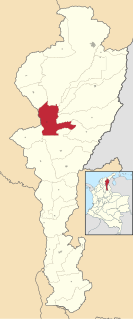
Los Robles La Paz or simply La Paz is a municipality and a town in the Department of Cesar, Colombia. The town is close to the Capital city of the Department of Cesar; Valledupar. The municipality of La Paz borders to the north with La Guajira Department, to the northeast with the municipality of Manaure. To the east with the Bolivarian Republic of Venezuela sharing the Serranía del Perijá mountain range. To the south with the municipality of Codazzi, southwest with the municipality of El Paso, Cesar. To the west with the municipality of San Diego and to the northwest with the municipality of Valledupar.

Pueblo Bello Municipality in Caribbean, Colombia

Pueblo Bello, is a village and municipality in the northern region of the Department of Cesar, Colombia. It is located in the mountains of the Sierra Nevada de Santa Marta and is home to Amerindians pertaining to the Arhuaco ethnicity, whom consider Pueblo Bello a sanctuary but by the name of Arumake in their language. Pueblo Bello is the main producer of coffee in the Caribbean Region of Colombia.

Chimichagua City in Caribbean, Colombia

Chimichagua is a city and municipality in the central region of the Department of Cesar, Colombia. Approximately one third of the municipality of Chimichagua is water. The municipality seat lies by the Cienaga de Zapatosa marshes.

Chiriguaná Place in Caribbean, Colombia

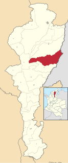
Chiriguaná is a city and municipality in the Department of Cesar, Colombia.

La Guajira Department Department of Colombia

La Guajira is a department of Colombia. It occupies most of the Guajira Peninsula in the northeast region of the country, on the Caribbean Sea and bordering Venezuela, at the northernmost tip of South America. The capital city of the department is Riohacha.

Becerril Town in Caribbean, Colombia

Becerril or Becerril de Campos is a town and municipality of the Colombian Department of Cesar.

Tamalameque Town in Caribbean, Colombia

Tamalameque is a town and municipality in the Colombian Department of Cesar. It was originally the site of a Chimila settlement, Thamara. Tamalameque is located on the right bank of the Magdalena River and borders Chimichagua and Pailitas in the north, Pelaya in the east, La Gloria in the south and in the west the departments of Bolívar and Magdalena.

Villanueva, La Guajira Town in Caribbean, Colombia

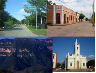
Villanueva is a town and municipality located in the northern Department of La Guajira, Colombia. Villanueva is known in Colombia for being the cradle of many vallenato singers and composers. The economy of the town relies heavily on agriculture and farming.

Barrancas, La Guajira Town in Caribbean, Colombia

Barrancas is a town and municipality of the Colombian Department of La Guajira. The municipality of Barrancas is located to the left margin of the Ranchería River in a valley formed between the Sierra Nevada de Santa Marta mountains and the Serranía del Perijá. Barrancas has a total area of 742 km2 and at 40 meters over sea level. The average temperature is 28 °C throughout the year and distances from the capital of the Department of La Guajira, Riohacha. It became a municipality in 1892.

Fonseca, La Guajira Town in Caribbean, Colombia

Fonseca is a municipality located in the Colombian Department of La Guajira. The town celebrates the Festival del Retorno in honor of St Augustine with religious celebrations, vallenato music events and others.

Urumita Town in Caribbean, Colombia

Urumita is a town and municipality of the Colombian Department of La Guajira.

Government of Santa Marta

The Government of Santa Marta was a capitulation given by the King of Spain between 1526 and 1618 to his loyals to manage newly discovered and conquered territories in the Americas. The Government of Santa Marta became part of the New Kingdom of Granada in 1528 as a subdivision. In 1549 the Government of Santa Marta was subject to the Royal Audience of Santa Fe de Bogotá.

Valencia de Jesús Place in Cesar, Colombia

Valencia de Jesús is a Colombian town and corregimiento of Valledupar in the Department of Cesar. The village is known for preserving one of the oldest churches in the Americas.

Atanquez Place in Cesar, Colombia

Atanquez or San Sebastian is a Colombian town and corregimiento of Valledupar in the Department of Cesar. Atanquez is located on the Sierra Nevada de Santa Marta mountain range at approximately 2,000 m over sea level. Atanquez is known for being predominantly inhabited by the indigenous ethnic group Kankuamos among others and mestizo groups.

Chimila people Indigenous people in the Andes of north-eastern Colombia

The Chimilas or Ette Ennaka are an indigenous people in the Andes of north-eastern Colombia. Their Chimila language is part of the Chibcha language family, of which there were estimated to be around 1000 speakers in 1998. At the time of the Spanish Conquest the Ariguaní River valley was the strategic centre of their territory. On the Serranía del Perijá mountains the Yukpas were also part of the Chimila confederation of tribes.

References