The House of Ascania was a dynasty of German rulers. It is also known as the House of Anhalt, which refers to its longest-held possession, Anhalt.

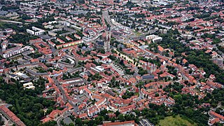
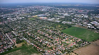
Merseburg is a town in central Germany located in the southern part of Saxony-Anhalt on the river Saale, approx. 14 km south of Halle (Saale) and 30 km west of Leipzig. It is the capital of the Saalekreis district. It had a diocese founded by Archbishop Adalbert of Magdeburg. The University of Merseburg is located within the town. Merseburg has around 33,000 inhabitants. Merseburg is part of the Central German Metropolitan Region.

Saxony, officially the Free State of Saxony, is a landlocked state of Germany, bordering the states of Brandenburg, Saxony-Anhalt, Thuringia, Bavaria, as well as the countries of Poland and the Czech Republic. Its capital is Dresden, and its largest city is Leipzig. Saxony is the tenth largest of Germany's sixteen states, with an area of 18,413 square kilometres (7,109 sq mi), and the sixth most populous, with more than 4 million inhabitants.

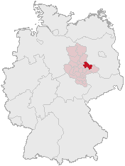
Saxony-Anhalt is a state of Germany, bordering the states of Brandenburg, Saxony, Thuringia and Lower Saxony. It covers an area of 20,447.7 square kilometres (7,894.9 sq mi) and has a population of 2.19 million inhabitants, making it the 8th-largest state in Germany by area and the 11th-largest by population. Its capital is Magdeburg and its largest city is Halle (Saale).

The Duchy of Anhalt was a historical German duchy. The duchy was located between the Harz Mountains in the west and the river Elbe and beyond to the Fläming Heath in the east. The territory was once ruled by the House of Ascania, and is now part of the federal state of Saxony-Anhalt.
A Verbandsgemeinde is a low-level administrative unit in the German federal states of Rhineland-Palatinate and Saxony-Anhalt. A Verbandsgemeinde is typically composed of a small group of villages or towns.
Anhalt-Zerbst was a district in Saxony-Anhalt, Germany. It is bounded by the districts Potsdam-Mittelmark (Brandenburg) and Wittenberg, the city of Dessau and the districts of Köthen, Schönebeck and Jerichower Land.
Wittenberg is a district in the east of Saxony-Anhalt, Germany. Neighboring districts are Anhalt-Bitterfeld, the district-free city of Dessau-Roßlau, the districts of Potsdam-Mittelmark, Teltow-Fläming and Elbe-Elster in Brandenburg, and the district of Nordsachsen in the Free State of Saxony. Capital and largest city is Wittenberg, a UNESCO world heritage.

The Province of Saxony, also known as Prussian Saxony was a province of the Kingdom of Prussia and later the Free State of Prussia from 1816 until 1944. Its capital was Magdeburg.
Halberstadt is a town in the German state of Saxony-Anhalt, the capital of Harz district. Located north of the Harz mountain range, it is known for its old town center that was greatly destroyed by Allied bombings in late stages of World War II after local Nazi leaders refused to surrender. The town was rebuilt in the following decades.

Zerbst is a town in the district of Anhalt-Bitterfeld, in Saxony-Anhalt, Germany. Until an administrative reform in 2007, Zerbst was the capital of the former Anhalt-Zerbst district.

Zeitz is a town in the Burgenlandkreis district, in Saxony-Anhalt, Germany. It is situated on the river White Elster, in the triangle of the federal states Saxony-Anhalt, Thuringia and Saxony.

Ballenstedt is a town in the Harz district, in the German state of Saxony-Anhalt.

Sangerhausen is a town in Saxony-Anhalt, central Germany, capital of the district of Mansfeld-Südharz. It is situated southeast of the Harz, approx. 35 kilometres east of Nordhausen, and 50 km (31 mi) west of Halle (Saale). About 26,000 people live in Sangerhausen (2020).

Havelberg is a town in the district of Stendal, in Saxony-Anhalt, Germany. It is situated on the Havel, and part of the town is built on an island in the centre of the river. The two parts were incorporated as a town in 1875. It has a population of 7,687 (2004).

Aschersleben is a town in the Salzlandkreis district, in Saxony-Anhalt, Germany. It is situated approximately 22 km east of Quedlinburg, and 45 km northwest of Halle (Saale).
Central Germany is an economic and cultural region in Germany. Its exact borders depend on context, but it is often defined as being a region within the federal states of Saxony, Thuringia and Saxony-Anhalt, or a smaller part of this region, such as the metropolitan area of Leipzig and Halle plus the surrounding counties.

Oranienbaum is a former town and a former municipality in the district of Wittenberg, in Saxony-Anhalt, Germany. Since 1 January 2011, it is a District of the town of Oranienbaum-Wörlitz. It is situated south of the Elbe, east of Dessau.
Dessau-Roßlau is a kreisfreie Stadt in the German state of Saxony-Anhalt. It is situated at the confluence of the rivers Elbe and Mulde. The town was formed by merger of the towns of Dessau and Roßlau in the course of the "Kreisreform Sachsen-Anhalt" (Sachsen-Anhalt Regional Boundary Reforms) on 1 July 2007. The reform involved a reduction in the number of rural districts in Sachsen-Anhalt from 21 to 11 and reflected an expected continuation of the significant population decline being experienced.

Bitterfeld-Wolfen is a town in the district Anhalt-Bitterfeld, Saxony-Anhalt, Germany. It is situated in south-eastern Saxony-Anhalt, west of the river Mulde, in an area that is dominated by heavy industry and lignite mining. The town was formed by merger of the towns Bitterfeld and Wolfen and the municipalities Greppin, Holzweißig and Thalheim on 1 July 2007.


