Holbeck Hall Hotel

Last updated

Holbeck Hall Hotel
Site of Holbeck Hall Hotel landslide.jpg
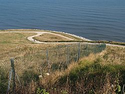
The site of the Holbeck Hall Hotel
Holbeck Hall Hotel
Former namesRoosevelt Hotel
General information
Type
  • Hotel
  • (originally private house)
Location Scarborough, North Yorkshire, England
Coordinates 54°16′00″N0°23′27″W / 54.26667°N 0.39083°W / 54.26667; -0.39083 (grid reference TA0486 )
Inaugurated1879
Destroyed5 June 1993 (1993-06-05)
ClientGeorge Alderson Smith
OwnerThe Turner Family
Technical details
Floor count3

The Holbeck Hall Hotel was a clifftop hotel in Scarborough, North Yorkshire, England, owned by the Turner family. It was built in 1879 by George Alderson Smith as a private residence, and was later converted to a hotel. [1]

On 4 June 1993, 55 metres (180 ft) of the 70 metres (230 ft) hotel garden had disappeared from view, the beginning of a landslide [2] which gradually became more severe, and finally on 5 June 1993, after a day of heavy rain, parts of the building collapsed, making news around the world. The hotel's chimney stack collapsed live on television just as Yorkshire TV's Calendar regional news programme went on air covering the building's precarious condition. Richard Whiteley was presenting the item at the time of the collapse. [3] The remainder of the building was demolished for safety reasons. One of the likely contributing causes of the landslide was the substantial rain in the two months before it occurred. The mud flow from the landslide protruded 135 metres (443 ft) beyond the high-water mark. [2]

Landslides are a common problem in Scarborough and along the coast from Filey to Whitby. [4] [5]

In 1997, the hotel's collapse became the subject of a significant court case in English civil law (Holbeck Hall Hotel Ltd v Scarborough BC [6] ) when the owners of the hotel attempted to sue Scarborough Borough Council for damages, alleging that as owners of the shoreline they had not taken any practical measures at all to prevent the landslip – from soft, to hard engineering, nothing was done. The claim was rejected on the grounds that the Council was not liable for the causes of the slip because it was not reasonably foreseeable. Reasonable foreseeability is a requirement for liability in negligence and nuisance in English and Welsh tort law. [7]

Related Research Articles

<span class="mw-page-title-main">North Yorkshire</span> County of England

North Yorkshire is a ceremonial county in the Yorkshire and the Humber and North East regions of England. It borders County Durham to the north, the North Sea to the east, the East Riding of Yorkshire to the south-east, South Yorkshire to the south, West Yorkshire to the south-west, and Cumbria and Lancashire to the west. Northallerton is the county town.

<span class="mw-page-title-main">Whitby</span> Coastal town in North Yorkshire, England

Whitby is a seaside town, port and civil parish in North Yorkshire, England. It is on the Yorkshire Coast at the mouth of the River Esk. It has a maritime, mineral and tourist economy. The fishing port emerged during the Middle Ages, supporting important herring and whaling fleets, and was where Captain Cook learned seamanship and, coincidentally, where his first vessel to explore the southern ocean, HMS Endeavour, was built. Jet and alum were mined locally, and Whitby jet, which was mined by the Romans and Victorians, became fashionable during the 19th century.

<span class="mw-page-title-main">North Riding of Yorkshire</span> Third of a historic county in England

The North Riding of Yorkshire was a subdivision of Yorkshire, England, alongside York, the East Riding and West Riding. The riding's highest point was at Mickle Fell at 2,585 ft (788 m).

<span class="mw-page-title-main">Scarborough, North Yorkshire</span> Town in North Yorkshire, England

Scarborough is a seaside town in the district and county of North Yorkshire, England. With a population of 61,749, Scarborough is the largest town on the Yorkshire Coast and the fourth-largest settlement in the county.

<span class="mw-page-title-main">Borough of Scarborough</span> Former local government district in England

The Borough of Scarborough was a non-metropolitan district with borough status in North Yorkshire, England. In addition to the town of Scarborough, it covered a large stretch of the coast of Yorkshire, including Whitby and Filey. It bordered Redcar and Cleveland to the north, the Ryedale and Hambleton districts to the west and the East Riding of Yorkshire to the south.

<span class="mw-page-title-main">Malton, North Yorkshire</span> Market town and civil parish in North Yorkshire, England

Malton is a market town, civil parish and electoral ward in North Yorkshire, England. Historically part of the North Riding of Yorkshire, the town has a population measured for both the civil parish and the electoral ward at the 2011 Census as 4,888.

<span class="mw-page-title-main">Scarborough and Whitby (UK Parliament constituency)</span> Parliamentary constituency in the United Kingdom

Scarborough and Whitby is a constituency in North Yorkshire represented in the House of Commons of the UK Parliament since 2005 by Robert Goodwill, a Conservative.

<span class="mw-page-title-main">Scalby, North Yorkshire</span> Village in North Yorkshire, England

Scalby, a village on the north edge of Scarborough, North Yorkshire, England, is part of the civil parish of Newby and Scalby. From 1902 to 1974, Scalby was an urban district in the North Riding of Yorkshire.

<span class="mw-page-title-main">Cayton</span> Village and civil parish in North Yorkshire, England

Cayton is a village and civil parish in the Scarborough borough of North Yorkshire, England, 4 miles (6 km) south of Scarborough.

<span class="mw-page-title-main">Coatham</span> Area of Redcar in North Yorkshire, England

Coatham is an area of Redcar in the borough of Redcar and Cleveland and the ceremonial county of North Yorkshire, England.

<span class="mw-page-title-main">1979 Abbotsford landslip</span>

On 8 August 1979, a major landslip occurred in the Dunedin, New Zealand suburb of Abbotsford. It was the largest landslide in a built-up area in New Zealand's history, resulting in the destruction of 69 houses – around one sixth of the suburb – but no fatalities.

<span class="mw-page-title-main">Hatfield Colliery</span> Former coal mine in South Yorkshire, England

Hatfield Colliery, also known as Hatfield Main Colliery, was a colliery in the South Yorkshire Coalfield, mining the High Hazel coal seam. The colliery was around 1 mile (1.6 km) northwest of Hatfield, South Yorkshire, adjacent north of the railway line from Doncaster to Scunthorpe northeast of Hatfield and Stainforth railway station.

<span class="mw-page-title-main">Knipe Point</span> Rocky headland in England

Knipe Point is a rocky headland on the North Sea coast, between Cornelian Bay and Cayton Bay in North Yorkshire, England. From this point, and running south, is the steeply sloping clay-till cliff on top of which stood the NALGO holiday camp between 1933 and 1974; this is where Knipe Point Drive was later built. The Cayton Cliff is subject to continuing surface landslips, potentially major at times, such as the one of 2008, known as the Knipe Point Landslide, which received national media attention due to the loss of three homes.

<span class="mw-page-title-main">2012 Great Britain and Ireland floods</span>

The 2012 Great Britain and Ireland floods were a series of weather events that affected parts of Great Britain and Ireland periodically during the course of 2012 and on through the winter into 2013. The beginning of 2012 saw much of the United Kingdom experiencing droughts and a heat wave in March. A series of low pressure systems steered by the jet stream brought the wettest April in 100 years, and flooding across Britain and Ireland. Continuing through May and leading to the wettest beginning to June in 150 years, with flooding and extreme events occurring periodically throughout Britain and parts of Atlantic Europe.

<span class="mw-page-title-main">Yorkshire Coast</span> Coastline of Yorkshire, England

The Yorkshire Coast runs from the Tees estuary to the Humber estuary, on the east coast of England. The cliffs at Boulby are the highest on the east coast of England, rising to 660 feet (200 m) above the sea level.

<span class="mw-page-title-main">Sea Cut (Scalby Beck)</span> River in North Yorkshire, England

The Sea Cut (Scalby Beck) is a small river that enters the North Sea at Scalby Mills, Scarborough, North Yorkshire, England. The beck is fed from local streams in Scalby, Newby and Burniston and other watercourses draining off the nearby hills. It is also a bypass channel for the upper reaches of the River Derwent when it is under flood conditions.

<span class="mw-page-title-main">Yorkshire coast fishery</span> History of sea fishing in Yorkshire, England

The Yorkshire coast fishery has long been part of the Yorkshire economy for centuries. The 114-mile (183 km) Yorkshire Coast, from the River Tees to the Humber estuary, has many ports both small and large where the fishing trade thrives. The historic ports at Hull and Whitby are important locations for the landing and processing of fish and shellfish. Scarborough and Bridlington are also sites of commercial fishing.

Paul Antony Darling is an English commercial law barrister, King's Counsel and current chair of the Horserace Betting Levy Board.

<span class="mw-page-title-main">Kex Gill Bypass</span> Future road in North Yorkshire, England

The Kex Gill Bypass is a future stretch of A-road across Kex Gill Moor to Blubberhouses in North Yorkshire, England. The route is part of the A59 road across the Pennines between Preston and York, with the Kex Gill Bypass being located within the Nidderdale Area of Outstanding Natural Beauty. The bypass is required as the 1820s built bypass is prone to landslips and road cracking, which accounted for eight weeks of closure in 2016. The bypass is expected to be 2.5 miles (4 km) long and to be opened in 2025.

<span class="mw-page-title-main">Port of Whitby</span> Port in North Yorkshire, England

The Port of Whitby is an ancient and historic seaport on the North Yorkshire coast of England. The port lies at the mouth of the River Esk, where it enters into the North Sea. A port has been in existence at Whitby since at least the 7th century, when it was used to bring in supplies for Whitby Abbey. The port is famous for being the port of origin for the sailings of Captain Cook, and some of the ships that he sailed on were also built in the harbour.

References

  1. Barwick, Sandra (12 June 1993). "Scarborough: postcards from the edge: Once golden sands and donkey rides were the big attraction. Now visitors come to watch the town's only four-star hotel fall into the sea". The Independent . London: INM. ISSN   0951-9467. OCLC   185201487 . Retrieved 28 May 2011.
  2. 1 2 "Holbeck Hall, Scarborough – landslide case study" . Retrieved 6 October 2020.
  3. "Holbeck Hall Hotel collapses on live TV". ITV Yorkshire. 6 June 1998. Archived from the original on 14 December 2021. Retrieved 22 February 2018 via YouTube.
  4. "North Yorkshire Coast Landslides – Landslips At Whitby". www.real-whitby.co.uk. Retrieved 6 October 2017.
  5. "Scarborough 'can't afford' to defend Spa from waves and landslides". The Yorkshire Post. 8 March 2014. Retrieved 6 October 2017.
  6. [2000] QB 836 (CA).
  7. "Holbeck Hall Hotel Ltd and another v Scarborough Borough Council". web.uct.ac.za. Archived from the original on 15 July 2012. Retrieved 5 October 2008.