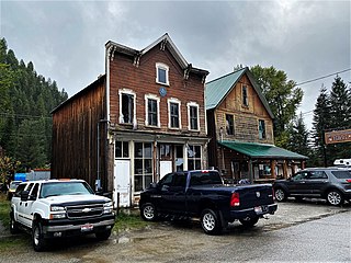
Murphy is a census-designated place in, and the county seat of, Owyhee County, Idaho, United States. It is among the smallest of county seats nationwide, with a population as of the 2020 census of 96. Murphy is part of the Boise City–Nampa, Idaho Metropolitan Statistical Area. Murphy is also located within the census-designated place bearing its name. Murphy is home to the Owyhee County Historical Museum and Library.
Bruneau is an unincorporated community in Owyhee County in the southwestern part of the U.S. state of Idaho. The mouth of the Bruneau River is to the northwest and Bruneau Sand Dunes State Park is to the east. As of 2014, Bruneau has a population of 552.

Clarkia is a small unincorporated community in the southwestern corner of Shoshone County, Idaho. It is surrounded by publicly and privately managed forest lands of Douglas-fir, Ponderosa Pine, and Western Larch. Located just to the east of State Highway 3, the town is in the drainage area of the West Fork of the St. Maries River.

Atlanta is an unincorporated community in the western United States, located in Elmore County, Idaho.

Cataldo is an unincorporated community in Kootenai and Shoshone counties in northern Idaho. It is located at an altitude of 2,139 feet (652 m). Cataldo lies on the southeast banks of the Coeur d'Alene River and Interstate 90 passes the south side of the community. The community of Kingston lies along I-90 to the east. The ZIP Code for Cataldo is 83810.
Cavendish is an unincorporated community in Clearwater County, Idaho, United States, in the mountains between the towns of Orofino and Kendrick. Cavendish contains an elementary school, a cemetery, and a park.
Geneva is an unincorporated community in on the eastern edge of Bear Lake County, Idaho, United States, near the Wyoming border.

Murray is an unincorporated community in the northwest United States, located in Shoshone County, Idaho. It is approximately twenty miles (32 km) north of Wallace along Dobson Pass Road. Prichard Creek flows through the community, forming a thin and deep valley in the surrounding Coeur d'Alene Mountains.
Ellis is an unincorporated community in Custer County, Idaho, United States, located on U.S. Route 93 15.5 miles (24.9 km) northeast of Challis. The town consists solely of a post office, with ZIP code 83235.
Howe is an unincorporated community in Butte County, Idaho, United States. Howe is located on Idaho State Highway 33 18 miles (29 km) northeast of Arco. Howe has a post office with ZIP code 83244.
Bayview is an unincorporated community in the northwest United States, located in Kootenai County, Idaho, north of Coeur d'Alene. On the southwest shore of Lake Pend Oreille, Bayview is seven miles (11 km) east-northeast of Athol. The community is served by State Highway 54 and a post office with ZIP code 83803; its approximate elevation is 2,100 feet (640 m) above sea level. Nearby is Farragut State Park, formerly the Farragut Naval Training Station, a major training facility during World War II.
Laclede is an unincorporated community in Bonner County, Idaho, United States. Laclede is located on U.S. Route 2 at the intersection of Riley Creek and the Pend Oreille River. Laclede has a post office with ZIP code 83841.

Harvard is an unincorporated community in the northwest United States, on the Palouse of north central Idaho in Latah County.
Lane is an unincorporated community in Kootenai County, Idaho, United States. Lane is located along the Coeur d'Alene River and Idaho State Highway 3. It is 12 miles (19 km) northeast of Harrison. The community was founded as a lumber town in the 1880s and named after a logger.
Cherry Creek is an unincorporated community in Oneida County, Idaho, United States. Cherry Creek is 6.5 miles (10.5 km) south of Malad City.
Mink Creek is an unincorporated community in Franklin County, Idaho, United States. Mink Creek is located along Idaho State Highway 36 12.5 miles (20.1 km) northeast of Preston.

State Highway 38 (SH‑38) is a 23.438-mile (37.720 km) east–west state highway in Oneida County, Idaho, United States, that connects 2100 West and Old Highway 37 with Interstate 15 (I‑15), just east of Malad City.

State Highway 37 is a 31.231-mile (50.261 km) north–south state highway in Power County, Idaho, United States, that connects Rockland Highway with Interstate 86/U.S. Route 30 in Idaho (I-86/US 30), southwest of American Falls.

Helmer is an unincorporated community in Latah County, Idaho, United States.
Elba is an unincorporated community in Cassia County, Idaho, United States, that is located along Idaho State Highway 77 Spur.


