
The Federal Aviation Administration (FAA) is a U.S. federal government agency within the U.S. Department of Transportation which regulates civil aviation in the United States and surrounding international waters. Its powers include air traffic control, certification of personnel and aircraft, setting standards for airports, and protection of U.S. assets during the launch or re-entry of commercial space vehicles, powers over neighboring international waters were delegated to the FAA by authority of the International Civil Aviation Organization.
Airspace is the portion of the atmosphere controlled by a country above its territory, including its territorial waters or, more generally, any specific three-dimensional portion of the atmosphere. It is not the same as outer space which is the expanse or space outside the Earth and aerospace which is the general term for Earth's atmosphere and the outer space within the planet's vicinity.

Laurence G. Hanscom Field, commonly known as Hanscom Field, is a public use airport operated by the Massachusetts Port Authority, located 14 mi outside Boston in Bedford, Massachusetts, United States.

In the United States, airways or air routes are defined by the Federal Aviation Administration (FAA) in two ways:
A NOTAM is a notice filed with an aviation authority to alert aircraft pilots of potential hazards along a flight route or at a location that could affect the flight. NOTAMs are notices or advisories that contain information concerning the establishment, conditions or change in any aeronautical facility, service, procedure or hazard, the timely knowledge of which may be essential to personnel and systems concerned with flight operations.
Clarksboro is an unincorporated community and historic area located in the municipality of East Greenwich Township in Gloucester County, in the U.S. state of New Jersey.
West Bend Municipal Airport is a city-owned public-use airport located three nautical miles (6 km) east of the central business district of West Bend, a city in Washington County, Wisconsin, United States. It is included in the Federal Aviation Administration (FAA) National Plan of Integrated Airport Systems for 2023–2027, in which it is categorized as a regional reliever airport facility.

Special use airspace (SUA) is a type of special airspaces in the United States designated for operations of a nature such that limitations may be imposed on aircraft not participating in those operations. Often these operations are of a military nature. The designation of SUAs identifies for other users the areas where such activity occurs, provides for segregation of that activity from other users, and allows charting to keep airspace users informed of potential hazards.
An aeronautical chart is a map designed to assist in the navigation of aircraft, much as nautical charts do for watercraft, or a roadmap does for drivers. Using these charts and other tools, pilots are able to determine their position, safe altitude, best route to a destination, navigation aids along the way, alternative landing areas in case of an in-flight emergency, and other useful information such as radio frequencies and airspace boundaries. There are charts for all land masses on Earth, and long-distance charts for trans-oceanic travel.

In United States aviation, a sectional aeronautical chart, often called a sectional chart or a sectional for short, is a type of aeronautical chart designed for air navigation under visual flight rules (VFR).

A World Aeronautical Chart (WAC) was a type of aeronautical chart used for navigation by pilots of moderate speed aircraft and aircraft at high altitudes in the United States. They are at a scale of 1:1,000,000. WACs were discontinued by the Federal Aviation Administration (FAA) in 2015.
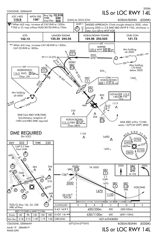
Approach plates are the printed or digital charts of instrument approach procedures that pilots use to fly instrument approaches during instrument flight rules (IFR) operations. Each country maintains its own instrument approach procedures according to International Civil Aviation Organization (ICAO) standards.

The United States airspace system's classification scheme is intended to maximize pilot flexibility within acceptable levels of risk appropriate to the type of operation and traffic density within that class of airspace – in particular to provide separation and active control in areas of dense or high-speed flight operations.
In United States and Canada aviation, terminal area charts are aeronautical charts intended for navigation under Visual Flight Rules that depict areas surrounding major airports, primarily those with Class B airspace.
This article describes the graphic conventions used in Sectional charts and Terminal area charts published for aeronautical navigation under Visual Flight Rules in the United States of America. The charts are published "in accordance with Interagency Air Cartographic Committee specifications and agreements, approved by the Department of Defense and the Federal Aviation Administration".
Cross Keys Airport is a privately-owned, public use airport located one nautical mile (2 km) south of the Cross Keys area of Monroe Township in Gloucester County, New Jersey. A skydiving operation is based at the airport.
The Air Traffic Organization (ATO) is an air navigation service provider in the United States of America. The ATO is the operational division of the Federal Aviation Administration (FAA).

On Thursday, January 15, 1987, SkyWest Airlines Flight 1834, a Swearingen SA-226TC, and a Mooney M20 were involved in a midair collision at 12:52 MST (UTC−7) near Kearns, Utah, a suburb southwest of Salt Lake City. All ten aboard the two aircraft were killed: two pilots and six passengers aboard the METRO II and two aboard the Mooney.
Westport Airport is a privately owned, public use airport located three nautical miles (6 km) southwest of the central business district of Wichita, a city in Sedgwick County, Kansas, United States. It is in the Class C airspace of neighboring Wichita Dwight D. Eisenhower National Airport.


