
Eyam is an English village and civil parish in the Derbyshire Dales that lies within the Peak District National Park. There is evidence of early occupation by Ancient Britons on the surrounding moors and lead was mined in the area by the Romans. A settlement was founded on the present site by Anglo-Saxons, when mining was continued and other industries later developed. However, Eyam’s main claim to fame is the story of how the village chose to go into isolation so as to prevent infection spreading after bubonic plague was discovered there in 1665.

Bakewell is a market town and civil parish in the Derbyshire Dales district of Derbyshire, England, known for Bakewell pudding. It lies on the River Wye, 15 miles (23 km) south-west of Sheffield. It is the largest settlement and only town within the boundaries of the Peak District National Park. At the 2011 census, the population of the civil parish was 3,949. It was estimated at 3,695 in 2019. The town is close to the tourist attractions of Chatsworth House and Haddon Hall.

Derbyshire Dales is a local government district in Derbyshire, England. The district was created in 1974 as West Derbyshire; the name was changed to Derbyshire Dales in 1987. The council is based in the town of Matlock, and the district also includes the towns of Ashbourne, Bakewell, Darley Dale and Wirksworth, as well as numerous villages and extensive rural areas. Much of the district is within the Peak District National Park.

The Hope Valley is a rural area centred on the village of Hope, Derbyshire, in the Peak District in the northern Midlands of England.

Graves Park ward—which includes the districts of Norton, Norton Lees, Norton Woodseats, and Woodseats—is one of the 28 electoral wards in City of Sheffield, England. It is located in the southern part of the city and covers an area of 5.8 km2. The population of this ward in 2011 was 16,705 people in 7,464 households. It is one of the five wards that form the Sheffield Heeley parliamentary constituency in the House of Commons. The districts of this ward were in the historic county of Derbyshire, but they have now been absorbed into the metropolitan borough of Sheffield, thus placing them in the ceremonial county of South Yorkshire.
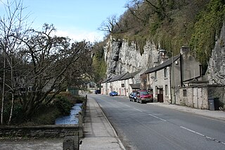
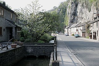
Stoney Middleton is a village and civil parish in the Derbyshire Dales district of Derbyshire, England. It is in the White Peak area of the Peak District southeast of Eyam and northwest of Calver, on the A623 road at the foot of the limestone valley of Middleton Dale. The population at the 2011 Census was 470.
Bentley Brook is a stream in Derbyshire, England. It rises on Matlock Moor, flowing south through Cuckoostone Dale, under the A632, into Lumsdale, gathering the valley's waters—notably from Knabhall Brook, out of Tansley, itself dammed and supporting large mills. In Lumsdale it enters a now disused mill pond or reservoir, then flows over a waterfall in the course of passing several historical mill ruins. Finally, it runs through control gates into the outside bend of a tight oxbow of the River Derwent, just beyond Hall Leys Park in Matlock. Although only about five miles in length, Bentley Brook is classed as a 'main river' by the Environment Agency.

Middleton or Middleton-by-Wirksworth is an upland village and civil parish lying approximately one mile NNW of Wirksworth, Derbyshire, England. Middleton was, in 1086, a berewick of the town and manor of Wirksworth. Middleton was formerly known for its lead mines and high quality limestone quarries, including the underground quarry site at Middleton Mine. The Middleton Mine networks underground for approximately 25 miles (40 km) with tunnels on three different levels running under Middleton Moor to the Hopton Wood quarry works at the other side of the hill below Ryder Point Works’. Part of the tunnel collapsed in the 1970s leaving a noticeable depression in the ground above on the eastern side of Middleton Moor. The population of the parish as taken at the 2011 Census was 775.

Chatsworth is a civil parish in Derbyshire, England, within the area of the Derbyshire Dales and the Peak District National Park.

Eyam Hall is a country house within the civil parish of Eyam, Derbyshire, located to the west of St Lawrence's Church, Eyam. It is recorded in the National Heritage List for England as a Grade II* listed building.

Dungworth is a hamlet in the civil parish of Bradfield, west of Sheffield in South Yorkshire, England.
The following is a timeline of the history of the city of Derby, England.

Nether Handley is a hamlet in North East Derbyshire in the county of Derbyshire in England.

Middleton Dale is a steep-sided, carboniferous limestone valley in the Derbyshire Peak District of England. The village of Stoney Middleton lies at the eastern foot of the dale and the village of Eyam lies about 600 metres (660 yd) to the north, through the side valley of Eyam Dale. The dale is cut into the surrounding gritstone uplands of Middleton Moor and Eyam Moor. Dale Brook stream runs down the dale into Stoke Brook and on into the River Derwent 1.5 kilometres (1 mi) beyond Stoney Middleton. The Delf is a secluded, wooded side gorge with a stream between Eyam and Middleton Dale. Opposite The Delf, water gushes from Hawkenedge Well and flows into Dale Brook.

Eyam Moor is a plateau-topped hill between the villages of Eyam and Hathersage in Derbyshire, in the Peak District of England. The summit of Sir William Hill is 429 metres (1,407 ft) above sea level.
Highlow is a civil parish within the Derbyshire Dales district, in the county of Derbyshire, England. Largely rural, Highlow's population is reported with the population of neighbouring parishes for a total of 585 residents in 2011. It is 140 miles (230 km) north-west of London, 28 miles (45 km) north-west of the county city of Derby, and 7+1⁄2 miles (12.1 km) north of the nearest market town of Bakewell. Highlow is wholly within the Peak District national park, and shares a border with the parishes of Abney and Abney Grange, Eyam, Foolow, Grindleford, Hathersage as well as Offerton. There are nine listed buildings in Highlow.

Jumber Brook is a stream in Eyam in the Derbyshire Peak District. The stream originates to the north of the village at Highcliffe. The brook flows south through the middle of the village before meeting the Dale Brook in Middleton Dale near Stoney Middleton.
Dale Brook is a stream in Stoney Middleton in the Derbyshire Peak District. The stream originates in Middleton Dale, where the Jumber Brook south of Eyam passes under the A623 becoming Dale Brook. The brook flows east through Stoney Middleton where it meets the Stoke Brook before joining the River Derwent at Calver.

Low Pavement is a short street located in Chesterfield, Derbyshire, England. It connects West Bars to Vicar Lane. The street is a shopping district.
