Geography

Holly Bluff is located at 32°49′17″N90°42′32″W / 32.82139°N 90.70889°W (32.82139, -90.70889).[ citation needed ]
The Village of Holly Bluff is a small unincorporated community in Yazoo County, Mississippi.
Originally known as "Sharbrough's Landing" to river boat pilots the community was established by the Sharbrough family in 1877. Located on the Sunflower River, early delta cotton planters used the river to ship their cotton to Vicksburg and New Orleans.
Holly Bluff is located at 32°49′17″N90°42′32″W / 32.82139°N 90.70889°W (32.82139, -90.70889).[ citation needed ]
Following the Civil War, two brothers, Franklin Wilson and John Walter Sharbrough came to the area now known as Holly Bluff. Their father, Franklin Wilson Sharbrough, a cotton planter from Smith County, Mississippi had lost everything during the war.
The Sharbrough brothers first lived in the area around Green Hill Plantation on Silver Creek. They worked together buying and clearing land for farming. The older brother, Franklin Wilson Sharbrough purchased the land on the north side of the Sunflower River and established Valley Home Plantation. John Walter purchased the land on the southern or Sharkey County side of the Sunflower River and called his place Patmos Plantation. Together, they built the first roads, bridges, levees and cotton gin in this part of the Mississippi Delta. Later, they built the first church then called "Sharbrough's Chapel" which still operates today as Holly Bluff United Methodist Church.
In 1906, the railroad requested the Sharbrough family change the name of Sharbrough's Landing to Sharbroughville. However, the family thought Sharbroughville would be too hard to spell and settled on the name Holly Bluff. Holly Bluff post office was established July 31, 1906, with Marcia M. Hackler as first postmaster. [1]
The Yazoo & Mississippi Valley Railroad had been incorporated in 1882 by the Illinois Central to penetrate the fertile Yazoo Delta. In 1905 a line of the Yazoo and Mississippi Valley Railroad, affectionately called the "Yellow Dog," was laid from Silver City, Mississippi to Holly Bluff. The principal purpose of the Holly Bluff line was to gain access to the cotton grown by the Sharbrough family in this rich section of the Mississippi Delta. After the building of the railroad, most of the cotton from Holly Bluff was sold in Memphis rather than New Orleans.
Located just outside Holly Bluff on Mississippi Highway 16 is the Lake George Mound site. The mounds were built during the prehistoric Temple Mound period. The largest mound rises 55 feet and is the fourth tallest native American mound in the United States. The mounds were built for religious ceremonies and not habitation. The site is important in that it is on the southern margin of the Mississippian cultural advance down the Mississippi River and on the northern edge of that of the Cole's Creek and Plaquemine cultures of the South.
The climate in this area is characterized by hot, humid summers and generally mild to cool winters. According to the Köppen Climate Classification system, Holly Bluff has a humid subtropical climate, abbreviated "Cfa" on climate maps. [2]
Residents are within the Yazoo County School District. Residents are zoned to Yazoo County Middle School and Yazoo County High School.

Yazoo County is a county located in the U.S. state of Mississippi. As of the 2020 census, the population was 26,743. The county seat is Yazoo City. It is named for the Yazoo River, which forms its western border. Its name is said to come from a Choctaw language word meaning "River of Death".

Clarksdale is a city in and the county seat of Coahoma County, Mississippi, United States. It is located along the Sunflower River. Clarksdale is named after John Clark, a settler who founded the city in the mid-19th century when he established a timber mill and business. The Clarksdale, MS Micropolitan Statistical Area includes all of Coahoma County. It is located in the Mississippi Delta region of Mississippi. In 2023, the Clarksdale, Mississippi Micropolitan area was added to form the new Memphis-Clarksdale-Forrest City Combined Statistical Area. The Memphis-Clarksdale-Forrest City Combined Statistical Area has around 1.4 million people.

Itta Bena is a city in Leflore County, Mississippi, United States. The population was 2,049 at the 2010 census. The town's name is derived from the Choctaw phrase iti bina, meaning "forest camp". Itta Bena is part of the Greenwood, Mississippi micropolitan area. It developed as a trading center of an area of cotton plantations.
Holly Springs is a city in, and the county seat of, Marshall County, Mississippi, United States, near the border with Tennessee to the north. Along with the Mississippi Delta, in the 19th century, the area was developed by European Americans for cotton plantations. After the Civil War, many freedmen continued to work in agriculture as sharecroppers and tenant farmers.

Magnolia is a city in Pike County, Mississippi and the county seat. The population was 2,420 at the 2010 census. Magnolia is within the McComb, Mississippi Micropolitan Statistical Area.

Doddsville is a town in Sunflower County, Mississippi. The population was 98 at the 2010 census. It was established by Daniel Doddsman Sr. in 1889.
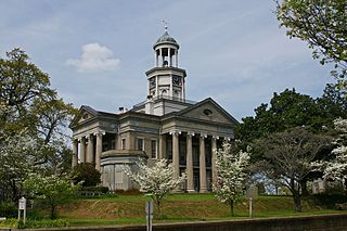
Vicksburg is a historic city in Warren County, Mississippi, United States. It is the county seat, and the population as of 2020 was 21,573.

Greenwood is a city in and the county seat of Leflore County, Mississippi, United States, located at the eastern edge of the Mississippi Delta region, approximately 96 miles north of the state capital, Jackson, and 130 miles south of the riverport of Memphis, Tennessee. It was a center of cotton planter culture in the 19th century.

The Mississippi Delta, also known as the Yazoo–Mississippi Delta, or simply the Delta, is the distinctive northwest section of the U.S. state of Mississippi that lies between the Mississippi and Yazoo rivers. The region has been called "The Most Southern Place on Earth", because of its unique racial, cultural, and economic history. It is 200 miles (320 km) long and 87 miles (140 km) across at its widest point, encompassing about 4,415,000 acres (17,870 km2), or, almost 7,000 square miles of alluvial floodplain. Originally covered in hardwood forest across the bottomlands, it was developed as one of the richest cotton-growing areas in the nation before the American Civil War (1861–1865). The region attracted many speculators who developed land along the riverfronts for cotton plantations; they became wealthy planters dependent on the labor of slaves, who composed the vast majority of the population in these counties well before the Civil War, often twice the number of whites.
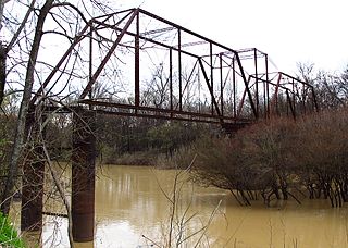
The Sunflower River is one of the main tributaries of the Yazoo River in the U.S. state of Mississippi. It is navigable by barge for 50 miles. It rises in De Soto County, Mississippi near the Tennessee border and flows south for 100 miles to the Yazoo River, a major tributary of the Mississippi River. At Clarksdale, the county seat of Coahoma County, the annual Sunflower River Blues & Gospel Festival is held.

Dockery Plantation was a 25,600-acre (104 km2) cotton plantation and sawmill in Dockery, Mississippi, on the Sunflower River between Ruleville and Cleveland, Mississippi. It is widely regarded as the place where Delta blues music was born. Blues musicians resident at Dockery included Charley Patton, Robert Johnson and Howlin' Wolf. The property was added to the National Register of Historic Places in 2006.

Baton Rouge station is a historic train station located at 100 South River Road in downtown Baton Rouge, Louisiana. It was built for the Yazoo and Mississippi Valley Railroad which got absorbed by the Illinois Central Railroad. The station was a stop on the Y&MV main line between Memphis, Tennessee and New Orleans, Louisiana. The building now houses the Louisiana Art and Science Museum.

The Holly Bluff site, sometimes known as the Lake George Site, and locally as "The Mound Place," is an archaeological site that is a type site for the Lake George phase of the prehistoric Plaquemine culture period of the area. The site is on the southern margin of the Mississippian cultural advance down the Mississippi River and on the northern edge of that of the Cole's Creek and Plaquemine cultures of the South." The site was first excavated by Clarence Bloomfield Moore in 1908 and tested by Philip Phillips, Paul Gebhard and Nick Zeigler in 1949.

The Winterville site is a major archaeological site in unincorporated Washington County, Mississippi, north of Greenville and along the river. It consists of major earthwork monuments, including more than twelve large platform mounds and cleared and filled plazas. It is the type site for the Winterville Phase of the Lower Yazoo Basin region of the Plaquemine Mississippian culture. Protected as a state park, it has been designated as a National Historic Landmark.
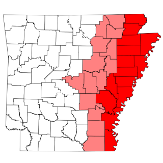
The Arkansas Delta is one of the six natural regions of the state of Arkansas. Willard B. Gatewood Jr., author of The Arkansas Delta: Land of Paradox, says that rich cotton lands of the Arkansas Delta make that area "The Deepest of the Deep South."
The Aden site is an archaeological site that is the type site for the Aden phase of Lower Yazoo Basin Coles Creek culture chronology. It corresponds to Middle Coles Creek, chronologically between the Bayland phase and Kings Crossing phase.
Grace is a census-designated place and unincorporated community in Issaquena County, Mississippi, United States. It is located several miles northeast of Mayersville.
The Spanish Fort Site (22-SH-500) is an archaeological site in the Delta region of the U.S. state of Mississippi. It is one of three major earthwork sites in the far southern portion of the Yazoo River valley, and it has been designated a historic site because of its archaeological value. Despite its name, the site was not built by the Spanish, and its original purpose is believed to have been ceremonial, not martial.
Walter Sillers Sr. was an American lawyer, politician, businessman, and planter in Mississippi. He played a significant role in the economic, agricultural, and political culture of the Mississippi Delta region. A cotton planter, he was an advocate for the establishment of crop control policies for the Southern United States through the development of planter's cooperatives. He was a key figure in the Mississippi Democratic Party and was responsible for the construction of levees in the Mississippi River Valley.

Mississippi Highway 433 (MS 433) is a state highway in western Mississippi consisting of two segments. The western segment, running entirely in Sharkey County is unsigned and runs for about 10.5 miles (16.9 km). The eastern segment, at a length of 45.3 miles (72.9 km), runs from Satartia in Yazoo County to rural Holmes County.
Municipalities and communities of Yazoo County, Mississippi, United States | ||
|---|---|---|
| City |  | |
| Town | ||
| Villages | ||
| CDP | ||
| Other communities | ||
| Ghost towns | ||