Yazoo County is a county located in the U.S. state of Mississippi. As of the 2010 census, the population was 28,065. The county seat is Yazoo City. It is named for the Yazoo River, which forms its western border. Its name is said to come from a Choctaw language word meaning "River of Death."

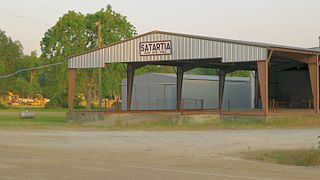
Satartia is a village in Yazoo County, Mississippi. The population was 68 as of the 2000 census. It is Mississippi's smallest incorporated municipality by population.

Yazoo City is a U.S. city in Yazoo County, Mississippi. It was named after the Yazoo River, which, in turn was named by the French explorer Robert La Salle in 1682 as "Rivière des Yazous" in reference to the Yazoo tribe living near the river's mouth. It is the county seat of Yazoo County and the principal city of the Yazoo City Micropolitan Statistical Area, which is part of the larger Jackson–Yazoo City Combined Statistical Area. According to the 2010 census, the population was 11,403.

Greenwood is a city in and the county seat of Leflore County, Mississippi, located at the eastern edge of the Mississippi Delta, approximately 96 miles north of the state capital, Jackson, Mississippi, and 130 miles south of the riverport of Memphis, Tennessee. It was a center of cotton planter culture in the 19th century.

Vaughan is an unincorporated community in Yazoo County, Mississippi.

The Hopewell tradition describes the common aspects of the Native American culture that flourished along rivers in the northeastern and midwestern Eastern Woodlands from 100 BCE to 500 CE, in the Middle Woodland period. The Hopewell tradition was not a single culture or society, but a widely dispersed set of related populations. They were connected by a common network of trade routes, known as the Hopewell exchange system.

The Mississippi Delta, also known as the Yazoo-Mississippi Delta, is the distinctive northwest section of the U.S. state of Mississippi which lies between the Mississippi and Yazoo Rivers. The region has been called "The Most Southern Place on Earth", because of its unique racial, cultural, and economic history. It is 200 miles (320 km) long and 87 miles (140 km) across at its widest point, encompassing about 4,415,000 acres (17,870 km2), or, almost 7,000 square miles of alluvial floodplain. Originally covered in hardwood forest across the bottomlands, it was developed as one of the richest cotton-growing areas in the nation before the American Civil War (1861–1865). The region attracted many speculators who developed land along the riverfronts for cotton plantations; they became wealthy planters dependent on the labor of black slaves, who composed the vast majority of the population in these counties well before the Civil War, often twice the number of whites.

Benton is an unincorporated community in Yazoo County, Mississippi.

Arkabutla Lake is a reservoir on the Coldwater River in the U.S. state of Mississippi. It was created following the construction of the Arkabutla Dam in 1940 on the Coldwater River.
The Village of Holly Bluff is a small unincorporated community in Yazoo County, Mississippi, in the Mississippi Delta.

The Holly Bluff Site, sometimes known as the Lake George Site, and locally as "The Mound Place," is an archaeological site that is a type site for the Lake George phase of the prehistoric Plaquemine culture period of the area. The site is on the southern margin of the Mississippian cultural advance down the Mississippi River and on the northern edge of that of the Cole's Creek and Plaquemine cultures of the South." The site was first excavated by Clarence Bloomfield Moore in 1908 and tested by Philip Phillips, Paul Gebhard and Nick Zeigler in 1949.

Carter is an unincorporated community located in northern Yazoo County, Mississippi. Carter is approximately 5 miles (8.0 km) north of Yazoo City and 9 miles (14 km) south of Silver City near U.S. Route 49W.

Tinsley is an unincorporated community located in Yazoo County, Mississippi, United States. Tinsley is approximately 11 miles (18 km) south of Yazoo City and 4 miles (6.4 km) North of Oil City near U.S. Route 49.

Oil City is an unincorporated community located in Yazoo County, Mississippi. Oil City is approximately 2 miles (3.2 km) west of Anding, 4 miles (6.4 km) south of Tinsley and approximately 8 miles (13 km) northwest of Bentonia.

Midway is an unincorporated community in Yazoo County, Mississippi, United States. Midway is located on Mississippi Highway 433 12.6 miles (20.3 km) east-northeast of Yazoo City.

Little Yazoo is an unincorporated community located in Yazoo County, Mississippi. Little Yazoo is approximately 5 miles (8.0 km) north of Bentonia and 2 miles (3.2 km) northeast of Anding on U.S. Route 49.

Brunswick is a ghost town in Warren County, Mississippi. Brunswick Landing, north of the community, was located directly on the Mississippi River.

Liverpool is a ghost town in Yazoo County, Mississippi, United States. Liverpool Landing, the settlement's port on the Yazoo River, was located 0.9 mi (1.4 km) west of Liverpool.

Flooding in the Mississippi River Basin during the winter, spring, and summer of 2019 caused at least 12 deaths and economic losses in 19 states totaling in excess of $20 billion. Estimated damages in the Midwestern United States alone had reached $12.5 billion by April 2019. Flood damages totaling $6.2 billion were reported in the 11 states bordering the Mississippi River. In addition to property and crop losses and infrastructure damages, commercial navigation on the Mississippi River was interrupted repeatedly by high currents, low bridge clearances, and closed locks. This delayed shipments of agricultural commodities, adding to the economic stress of crop losses caused by flooding. As of late April 2019, shipments of corn to export terminals in Louisiana were 31% lower than in same period in 2018.


