The Puebloans or Pueblo peoples, are Native Americans in the Southwestern United States who share common agricultural, material and religious practices. When Spaniards entered the area beginning in the 16th century, they came across complex, multi-story villages built of adobe, stone and other local materials, which they called pueblos, or towns, a term that later came to refer also to the peoples who live in these villages.

Santa Clara Pueblo is a census-designated place (CDP) in Rio Arriba County, New Mexico, United States and a federally recognized tribe of Native American Pueblo people. Santa Clara Pueblo was established about 1550.
San Ildefonso Pueblo is a census-designated place (CDP) in Santa Fe County, New Mexico, United States, and a federally recognized tribe, established c. 1300 C.E. The Pueblo is self-governing and is part of the Santa Fe, New Mexico Metropolitan Statistical Area. The population was 524 as of the 2010 census, reported by the State of New Mexico as 1,524 in 2012, and there were 628 enrolled tribal members reported as of 2012 according to the Department of the Interior. San Ildefonso Pueblo is a member of the Eight Northern Pueblos, and the pueblo people are from the Tewa ethnic group of Native Americans, who speak the Tewa language.

Chaco Culture National Historical Park is a United States National Historical Park hosting the densest and most exceptional concentration of pueblos in the American Southwest. The park is located in northwestern New Mexico, between Albuquerque and Farmington, in a remote canyon cut by the Chaco Wash. Containing the most sweeping collection of ancient ruins north of Mexico, the park preserves one of the most important pre-Columbian cultural and historical areas in the United States.
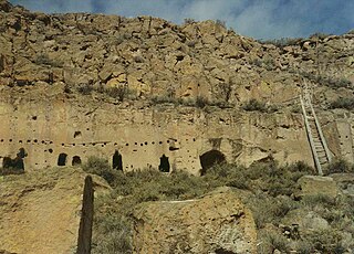
The Puye Cliff Dwellings are the ruins of an abandoned pueblo, located in Santa Clara Canyon on Santa Clara Pueblo land near Española, New Mexico. The site was declared a National Historic Landmark in 1966.

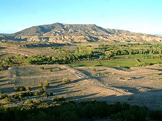
The Jemez Mountains ([ˡhɛmɛz]) are a volcanic group of mountains in Rio Arriba, Sandoval, and Los Alamos counties, New Mexico, United States.
The Hopi Reservation is a Native American reservation for the Hopi and Arizona Tewa people, surrounded entirely by the Navajo Nation, in Navajo and Coconino counties of Arizona, United States. The site in north-eastern Arizona has a land area of 2,531.773 sq mi (6,557.262 km²) and as of the 2000 census had a population of 6,946. The Hopi Reservation, like most of Arizona but unlike the surrounding Navajo Nation, does not observe daylight saving time. Until recently, the two nations shared the Navajo–Hopi Joint Use Area. The partition of this area, commonly known as Big Mountain, by Acts of Congress in 1974 and 1996, has resulted in continuing controversy.

Ysleta del Sur Pueblo is a Puebloan Native American tribal entity in the Ysleta section of El Paso, Texas. Its members are Southern Tiwa people who had been displaced from Spanish New Mexico in 1680-1681 during the Pueblo Revolt against the Spaniards.

Pueblo Bonito is the largest and best-known great house in Chaco Culture National Historical Park, northern New Mexico. It was built by the Ancestral Puebloans who occupied the structure between AD 828 and 1126.

Ohkay Owingeh is a census-designated place (CDP) in Rio Arriba County, New Mexico, United States and a federally recognized tribe of Native American Pueblo people. The 2010 census found that 1,143 people lived in the CDP, while 1,522 people in the U.S. reported being exclusively Ohkay Owingeh and 1,770 people reported being Ohkay Owingeh exclusively or in combination with another group.
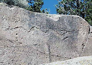
Tsirege is a classic Anasazi Pueblo archaeological site located north of Pajarito Road about one mile west of White Rock, New Mexico on property owned by Los Alamos National Laboratory. Tsirege consists of approximately 800 rooms, was occupied from c. 1325 to c. 1600, and is regarded by the people of San Ildefonso Pueblo as ancestral. The name means "bird place" in the Tewa language. The site includes a long defensive wall, 10 kivas, a reservoir, and many significant petroglyph panels. Tours of the site are rarely offered.

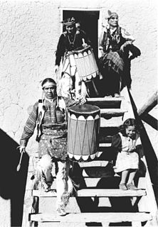
The Pueblo clowns are jesters or tricksters in the Kachina religion. It is a generic term, as there are a number of these figures in the ritual practice of the Pueblo people. Each has a unique role; belonging to separate Kivas and each has a name that differs from one mesa or pueblo to another.

Salmon Ruins is an ancient Chacoan and Pueblo site located in the northwest corner of New Mexico, USA. Salmon was constructed by migrants from Chaco Canyon around 1090 CE, with 275 to 300 original rooms spread across three stories, an elevated tower kiva in its central portion, and a great kiva in its plaza. Subsequent use by local Middle San Juan people resulted in extensive modifications to the original building, with the reuse of hundreds of rooms, division of many of the original large, Chacoan rooms into smaller rooms, and emplacement of more than 20 small kivas into pueblo rooms and plaza areas. The site was occupied by ancient Ancestral Puebloans until the 1280s, when much of the site was destroyed by fire and abandoned. The pueblo is situated on the north bank of the San Juan River, just to the west of the modern town of Bloomfield, New Mexico, and about 45 miles (72 km) north of Pueblo Bonito in Chaco Canyon. The site was built on the first alluvial terrace above the San Juan River floodplain.

The Poeh Museum is a museum in Pojoaque, New Mexico, U.S.A. The museum is located off U.S. Route 84. It is devoted to the arts and culture of the Puebloan peoples, especially the Tewas in the northern part of the state. It was founded by Pojoaque Pueblo in 1987, and is housed in the Poeh Center. The museum organizes changing exhibitions, and is a large repository of permanent artifacts and programs. The museum has run the Oral Histories Documentation, which is part of the Museum's records, which involved participation of 38 Tewa elders providing stories about their lives; the information is available in both Tewa and English.
Poeh Center is a cultural center in the U.S. state of New Mexico. Established by Pojoaque Pueblo, it is devoted to the arts and culture of the Puebloan peoples. The center is located off of U.S. Route 84. It is near Pojoaque Pueblo's Cities of Gold Casino and Hotel, and about 16 miles (26 km) from Santa Fe. Construction started in 1992 with gaming revenue, and was completed in 2003.
Poshuouinge is a large ancestral Pueblo ruin located on U.S. Route 84, about 2.5 miles (4.0 km) south of Abiquiu, New Mexico. Its builders were the ancestors of the Tewa Pueblos who now (2011) reside in Santa Clara Pueblo and San Juan Pueblo. It has also been referred to informally as Turquoise Ruin, although there is no evidence that turquoise has ever been found in the area. Poshuouinge is situated 3 miles (4.8 km) upstream and due west of another Tewa Pueblo ancestral site, Tsama.
Fesere is one of the principal Tewa Pueblo ancestral sites in New Mexico, US. The prehistoric pueblo is situated on a mesa west or south of the Rio Chama, near Abiquiu, Rio Arriba County.
Teeuinge is one of the principal Tewa Pueblo ancestral sites in New Mexico, US. It is situated in the southerly angle formed by the juncture of Rio Oso and Rio Chama. The site measures approximately 525 feet (160 m) by 210 feet (64 m). It is a large ruin situated on the rim of the mesa overlooking the valley, just below the confluence of the two rivers. It is about .25 miles (0.40 km) south of the river, and the bluff on which it stands is about 200 feet (61 m). The pueblo was constructed of adobe with some use of lava blocks in the foundation walls, and is now reduced to low mounds. It was built in two large adjoining quadrangles, or as one long rectangle divided by cross walls into two courts. The walls have a perimeter of 1,470 feet (450 m). Within and contiguous to the pueblo are ten circular, subterranean kivas. A few yards to the east is a ruined shrine in circular form, 8 feet (2.4 m) in diameter, built of lava blocks set on edge.


