Home Rule, New South Wales

Last updated

Home Rule
New South Wales
Home Rule Hotel, New South Wales, c.1872.jpg
Home Rule Hotel, c.1872. From the Holtermann Collection
Australia New South Wales location map blank.svg
Red pog.svg
Home Rule
Coordinates 32°26′04″S149°36′51″E / 32.4344867°S 149.614146°E / -32.4344867; 149.614146
Population55 (SAL 2021) [1]
Postcode(s) 2850 [2]
Location

Home Rule is locality in the Central West region of New South Wales. Little remains of the 19th-century gold rush era village of the same name, which lies within the locality.

Contents

Photograph taken c.1872 of shops at Home Rule. From the Holtermann Collection. Shops at Home Rule, New South Wales c.1872.jpg
Photograph taken c.1872 of shops at Home Rule. From the Holtermann Collection.

History

The area now known as Home Rule lies on the traditional lands of Wiradjuri people. [3]

Prospectors worked progressively from Gulgong (gold discovered in 1870), through Canadian Lead (gold discovered in 1871), and found gold at Home Rule, in May 1872, in deep lead deposits. [4] [5]

On 9 July 1872 The Maitland Mercury and Hunter River General Advertiser reported that:

"The scene at Home Rule is a busy one, and very few people can form an idea of it unless they go and see for themselves. A township is in rapid formation, and streets are being made close to the golden holes. One digger refused £500 for a share in a claim on the right spot. Everyone appears sanguine. The storekeepers and publicans look remarkably pleasant, as if they anticipated rich harvests, and even John Chinaman smiles graciously on meeting you. It would almost be an impossibility to give an account of the different claims, as they extend for miles; and until the dispute as to the frontage and block system is settled, many men will prefer to be idle." [6]

The mining village at Home Rule came into existence immediately after the discovery of gold there. Home Rule had about 3,000 inhabitants when, on 15 July 1872, Charles Bayliss took a series of photographs of businesses in the village, together with those owners, staff and customers who happened to be there at the time. [4] These glass plate negative photographs form a part of the Holtermann Collection. [4]

Around 1904, there was a revival of deep lead mining in the area. [7] [8]

There was a public school there, from November 1874 until December 1957. It was first called Home Rule, until December 1874, Mobellah until May 1913, then Wyaldra, before reverting to its original name of Home Rule in December 1913. [9]

Remnants of the village

The names of three streets of the old mining village, Commercial Street, Stanley Street, and Britannia Road are still applied to modern-day roads. The portion of Commercial Street that runs east-to-west corresponds to the old main street of the mining village. Britannia Road running north-to-south corresponds to the original street, where the old school building survives. [10] [11]

There is a water-filled mining pit lying to the east of the eastern end of Commercial Street. [10] [11]

Related Research Articles

<span class="mw-page-title-main">Cudgegong River</span> River in New South Wales, Australia

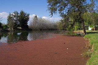
Cudgegong River, a perennial stream that is part of the Macquarie catchment within the Murray–Darling basin, is located in the central western and Orana districts of New South Wales, Australia.

<span class="mw-page-title-main">Mudgee</span> Town in New South Wales, Australia

Mudgee is a town in the Central West of New South Wales, Australia. It is in the broad fertile Cudgegong River valley 261 km (162 mi) north-west of Sydney and is the largest town in the Mid-Western Regional Council local government area as well as being the council seat. As at June 2021 its population was 12,563. The district lies across the edge of the geological structure known as the Sydney Basin.

<span class="mw-page-title-main">Gulgong</span> Town in New South Wales, Australia

Gulgong is a 19th-century gold rush town in the Central Tablelands and the wider Central West regions of the Australian state of New South Wales. The town is situated within the Mid-Western Regional Council local government area. It is located about 300 km (190 mi) north west of Sydney, and about 30 km north of Mudgee along the Castlereagh Highway. At the 2016 Census, Gulgong had a population of 2,521.

<span class="mw-page-title-main">Mid-Western Regional Council</span> Local government area in New South Wales, Australia

The Mid-Western Regional Council is a local government area in the Central West region of New South Wales, Australia. The area is located adjacent to the Castlereagh Highway that passes through the middle of the area in an approximate southeast–northwest direction.

<span class="mw-page-title-main">Rylstone, New South Wales</span> Town in New South Wales, Australia

Rylstone is a small town in New South Wales, Australia, in the Central Tablelands region within the Mid-Western Regional Council local government area. It is located on the Bylong Valley Way road route. At the 2021 census, Rylstone had a population of 904.

<span class="mw-page-title-main">Baerami, New South Wales</span> Town in New South Wales, Australia

Baerami is a locality in the Muswellbrook Shire in the Upper Hunter region of New South Wales, Australia.

Tallawang is an historical locality north of Gulgong in central western New South Wales, Australia. The place name is derived from an aboriginal word for "apple gum".

<span class="mw-page-title-main">Leadville, New South Wales</span> Town in New South Wales, Australia

Leadville is a town in New South Wales, Australia. The town is located in the Warrumbungle Shire local government area, 376 kilometres (234 mi) north west of the state capital, Sydney. At the 2016 census, Leadville and the surrounding area had a population of 169.

<span class="mw-page-title-main">Wollar</span> Town in New South Wales, Australia

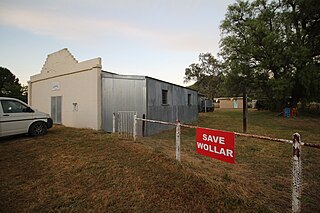
Wollar is a village in New South Wales, Australia. The town is located 316 kilometres (196 mi) north west of the state capital Sydney and 48 kilometres (30 mi) north-east of the regional centre of Mudgee, near the Goulburn River National Park. At the 2006 census, Wollar and the surrounding region had a population of 304. By the 2016 census the village of Wollar and district was reduced to 69 persons living in 50 private dwellings.

David Hugh Spring was an Australian politician, member of the New South Wales Legislative Assembly.

New South Wales experienced the first gold rush in Australia, a period generally accepted to lie between 1851 and 1880. This period in the history of New South Wales resulted in a rapid growth in the population and significant boost to the economy of the colony of New South Wales. The California Gold Rush three years prior signaled the impacts on society that gold fever would produce, both positive and negative. The New South Wales colonial government concealed the early discoveries, but various factors changed the policy.

<span class="mw-page-title-main">Canadian Lead, New South Wales</span> Town in New South Wales, Australia

Canadian Lead is a 19th-century gold rush town in rural New South Wales, Australia. It is 301 km to Sydney.

<span class="mw-page-title-main">Henry Beaufoy Merlin</span>

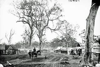
Henry Beaufoy Merlin (1830–1873) was an Australian photographer, showman, illusionist and illustrator. In the 1850s he worked as a theatrical showman and performer in Sydney, Newcastle and Maitland. In 1863 he was the first person to introduce Pepper's ghost to Australia. After this, he took up photography and between 1869 and 1872 turned the American Australasian Photographic Company into one of the most respected studios in Australia. Between 1872 and 1873 he worked extensively documenting the goldfields and mining towns of New South Wales. In 1873, as an employee of Bernhardt Holtermann, he photographed Sydney and many rural New South Wales towns. He died on 27 September 1873.

<span class="mw-page-title-main">Holtermann collection</span>

The Holtermann Collection is the name given to a collection of over 3,500 glass-plate negatives and albumen prints, many of which depict life in New South Wales goldfield towns. It also includes numerous photographs of Australian rural towns and the cities of Sydney and Melbourne taken between 1871 and 1876. The collection is held by the State Library of New South Wales.

<i>Mudgee Guardian and Gulgong Advertiser</i>

The Mudgee Guardian and Gulgong Advertiser is an English language newspaper published in Mudgee, New South Wales, Australia. It was established in 1890 under the name Mudgee Guardian and North-Western Representative.

Thomas Frederic De Courcy Browne was an Irish-born Australian politician and journalist.

<span class="mw-page-title-main">Yarrabin, New South Wales</span> Town in New South Wales, Australia

Yarrabin is a ghost town near the junction of the Meroo and Cudgegong rivers in the New South Wales Orana Region. The village of Merrendee was established after the discovery of gold in that area around 1851 and was located approximately 23 miles west of Mudgee. The locality was renamed Yarrabin by postal authorities in 1923.

<span class="mw-page-title-main">The Greatest Wonder of the World and American Tobacco Warehouse and Fancy Goods Emporium</span> Historic site in New South Wales, Australia

The Greatest Wonder of the World and American Tobacco Warehouse and Fancy Goods Emporium are heritage-listed adjacent shops at 123-125 Mayne Street, Gulgong, Mid-Western Regional Council, New South Wales, Australia. They were built from 1870 to 1878. They have been refurbished to house the Gulgong Holtermann Museum, with new galleries constructed at the back to house the UNESCO listed HOLTERMANN COLLECTION. The original buildings were added to the New South Wales State Heritage Register on 21 October 2016.

Dalmorton is a locality in the Northern Rivers region of New South Wales, Australia. There once was a village of the same name, which was associated with gold mining. Much of the area of the locality is now reserved as National Parks or State Forests. At the 2016 census, the population of Dalmorton was four.

Lidsdale is a locality within the City of Lithgow Local Government Area of New South Wales, Australia. It lies to the north of Wallerawang. Its area, as defined for postal and statistical purposes, includes the historic locality of Kerosene Vale and the small rural areas known as Springvale and Angus Place. In 2021, its population was 471.

References

  1. Australian Bureau of Statistics (28 June 2022). "Home Rule (Suburb and Locality)". Australian Census 2021 QuickStats. Retrieved 28 June 2022.  OOjs UI icon edit-ltr-progressive.svg
  2. "Home Rule in Google Map". Google Map. Retrieved 6 June 2014.
  3. Studies, Australian Institute of Aboriginal and Torres Strait Islander (28 July 2023). "Map of Indigenous Australia". aiatsis.gov.au. Retrieved 5 September 2023.
  4. 1 2 3 "Home Rule! (Not a call to arms)". State Library of NSW. 10 September 2015. Retrieved 5 September 2023.
  5. "The Mining Record". Sydney Mail and New South Wales Advertiser . 6 July 1872. p. 19. Retrieved 5 September 2023.
  6. "THE MUDGEE GOLD FIELDS". The Maitland Mercury and Hunter River General Advertiser . Vol. XXIX, no. 3768. New South Wales, Australia. 9 July 1872. p. 2 via National Library of Australia.
  7. "The Home Rule Gold Field". Mudgee Guardian and North-Western Representative . 6 July 1900. p. 12. Retrieved 5 September 2023.
  8. "Gold Near Home Rule". Australian Town and Country Journal . 29 June 1904. p. 24. Retrieved 5 September 2023.
  9. "Home Rule". nswgovschoolhistory.cese.nsw.gov.au. Retrieved 5 September 2023.
  10. 1 2 "Village of Home Rule and adjoining lands [cartographic material] : Parish - Wyaldra, County - Phillip, Land District - Mudgee, Shire - Cudgegong". Trove. Retrieved 5 September 2023.
  11. 1 2 "Satellite View - Old village site at Home Rule · New South Wales 2850, Australia". Google Maps. Retrieved 5 September 2023.