
Brewster County is a county located in the U.S. state of Texas. It is in West Texas and its county seat is Alpine. It is one of the nine counties that comprise the Trans-Pecos region, and borders Mexico. Brewster County is the largest county by area in the state - at 6,192 square miles (16,040 km2) it is over three times the size of the state of Delaware, and more than 500 square miles (1,300 km2) bigger than Connecticut.

Big Bend National Park is an American national park located in West Texas, bordering Mexico. The park has national significance as the largest protected area of Chihuahuan Desert topography and ecology in the United States, and was named after a large bend in the Rio Grande/Río Bravo. The park protects more than 1,200 species of plants, more than 450 species of birds, 56 species of reptiles, and 75 species of mammals. Additional park activities include scenic drives, programs led by Big Bend park rangers, and stargazing.

Richard Montgomery Gano was a physician, Protestant minister, and brigadier general in the army of the Confederate States during the American Civil War.

Middleton Place is a plantation in Dorchester County, along the banks of the Ashley River west of the Ashley and about 15 miles (24 km) northwest of downtown Charleston, in the U.S. state of South Carolina. Built in several phases during the 18th and 19th centuries, the plantation was the primary residence of several generations of the Middleton family, many of whom played prominent roles in the colonial and antebellum history of South Carolina. The plantation, now a National Historic Landmark District, is used as a museum, and is home to the oldest landscaped gardens in the United States.

The Orcutt Ranch Horticulture Center, formally known as Rancho Sombra del Roble, is a Los Angeles Historic-Cultural Monument located in the West Hills section of Los Angeles, California, USA.

The Snake River Land Company Residence and Office are structures associated with John D. Rockefeller Jr.'s acquisition of land in Jackson Hole, Wyoming, United States. Under the guise of the Snake River Land Company, Rockefeller bought much of the land that he eventually donated to the National Park Service, first as Jackson Hole National Monument and a year later as Grand Teton National Park. The buildings are located in the park, in the community of Moran. They served as the residence and office for SRLC vice president Harold Fabian and foreman J. Allan from 1930 to 1945. The buildings are still used by the National Park Service. The property was owned from 1926 to 1930 by John Hogan, a retired politician from the eastern United States. The Snake River Land Company bought the property in 1930.

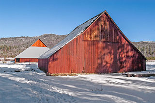
The TA Ranch was the site of the principal events of the Johnson County Range War in 1892. The TA was established in 1882 as one of the first ranches in Johnson County, Wyoming. The TA is the only intact site associated with the range war, with trenches used by both sides still visible and scars on the nearby buildings. The ranch also documents the expansion and development of cattle ranching in Wyoming.

The Buckner Homestead Historic District, near Stehekin, Washington in Lake Chelan National Recreation Area incorporates a group of structures relating to the theme of early settlement in the Lake Chelan area. Representing a time period of over six decades, from 1889 to the 1950s, the district comprises 15 buildings, landscape structures and ruins, and over 50 acres (200,000 m2) of land planted in orchard and criss-crossed by hand-dug irrigation ditches. The oldest building on the farm is a cabin built in 1889. The Buckner family bought the farm in 1910 and remained there until 1970, when the property was sold to the National Park Service. The Buckner Cabin was listed on the National Register of Historic Places in 1974. The rest of the Buckner farm became a historic district in 1989. Today, the National Park Service maintains the Buckner homestead and farm as an interpretive center to give visitors a glimpse at pioneer farm life in the Stehekin Valley.
The Manning–Kamna Farm is a private farm adjacent to Hillsboro in Washington County, Oregon, United States. Settled in the 1850s, ten buildings built between 1883 and 1930 still stand, including the cross-wing western farmhouse. These ten structures comprise the buildings added to the National Register of Historic Places in 2007 as an example of a farm in the region from the turn of the 20th century. Until the 1950s the farm was used to grow seeds, including rye grass and vetch. Listed buildings on the property include a barn, smokehouse, pumphouse, woodshed, and privy.
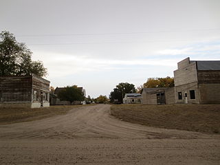
The Jay Em Historic District comprises the abandoned center of the village of Jay Em, Wyoming. The town was planned and established by Lake Harris between 1912 and 1915 as a service town supporting ranchers in the surrounding area. The place was recognized as a town in 1915 when a post office was established. Tours of the site are available by appointment.

The Charles Boyd Homestead is a group of three buildings that make up a pioneer ranch complex. It is located in Deschutes County north of Bend, Oregon, United States. The ranch buildings were constructed by Charles Boyd between 1905 and 1909. Today, the three surviving structures are the only ranch buildings that date back to the earliest period of settlement in the Bend area. The Boyd Homestead is listed as a historic district on the National Register of Historic Places.

The historical buildings and structures of Zion National Park represent a variety of buildings, interpretive structures, signs and infrastructure associated with the National Park Service's operations in Zion National Park, Utah. Structures vary in size and scale from the Zion Lodge to road culverts and curbs, nearly all of which were designed using native materials and regional construction techniques in an adapted version of the National Park Service Rustic style. A number of the larger structures were designed by Gilbert Stanley Underwood, while many of the smaller structures were designed or coordinated with the National Park Service Branch of Plans and Designs. The bulk of the historic structures date to the 1920s and 1930s. Most of the structures of the 1930s were built using Civilian Conservation Corps labor.

The David L. Shirk Ranch is a historic ranch located in the Guano Valley of eastern Lake County, Oregon, United States. The ranch was originally homesteaded in 1881. It was purchased by David L. Shirk in 1883. He operated the ranch until 1914. The property was acquired by the United States Government in 1942. The ranch is now administered by the Bureau of Land Management. The remaining historic ranch buildings are listed on the National Register of Historic Places.

The Luna Jacal or Luna's Jacal was the residence of Gilberto Luna, a Mexican pioneer farmer in the area of Texas that would become Big Bend National Park. The jacal, an indigenous Tejano dwelling suited to the desert environment, was built about 1890 with a low sandstone and limestone wall about 4 feet (1.2 m), with forked poles set upright into the walls, supporting roof poles. The house backs up to a large boulder. A heavier line of poles extends the length of the jacal. The roof was made of ocotillo branches weighted down with earth and stones, presently replaced with an inappropriate soil-cement roof. Luna raised a large family at the jacal, peacefully coexisting with otherwise hostile Comanche who used the Alamo Creek area as a war trail. Luna died there in 1947 at age 108 or 109.
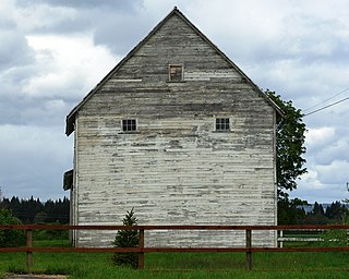
The McCauley and Meyer Barns in Yosemite National Park are the last barns in the park that retain their original characteristics as structures built by homesteaders. The McCauley barn and the two Meyer barns represent different construction techniques and styles of design.

Castolon, also known as La Harmonia Ranch and Campo Santa Helena, was a small community in southwestern Texas, United States, located in what is now Big Bend National Park along the Rio Grande. The location was first settled in 1901 by Cipriano Hernandez, who farmed the area and built the original Castolon Store, now known as the Alvino House.
Rancho Estelle was the home of James Sublett, one of the first large-scale farmers in the Rio Grande valley of Texas, within what is now Big Bend National Park. Prior to founding the ranch, Sublett and his partner, Clyde Buttrill, farmed the bottomlands along the river in the area of what is now known as Castolon or La Harmonia, downstream from the later ranch. After the partnership with Buttrill broke up, Sublett bought four sections of land, initially calling it Grand Canyon Farms, and later Rancho Estelle.

The Daniels Farm House represents one of the last vestiges of West Texas pioneer farming in Big Bend National Park, Texas. Most of the small-scale farms in the Big Bend area quickly fell into ruin after the park was established in 1944. Larger-scale ranch structures survived in greater numbers, but the small-scale irrigated bottomland farms have not. The farm is located next to the Rio Grande.
The Ernest and Mary Hemingway House, in Ketchum, Idaho, is listed on the National Register of Historic Places in 2015. The National Register does not disclose its location but rather lists it as "Address restricted." The property is the last undeveloped property of its size within the city limits of Ketchum.

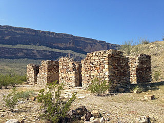
The Bear Spring House, Guardhouse, and Spring is a late 19th century ranch situated in the Chiricahua Mountains in Cochise County, Arizona


