
Marnardal is a municipality in Vest-Agder county, Norway. It is located in the traditional district of Sørlandet. The administrative centre of the municipality is the village of Heddeland. Other villages in Marnardal include Bjelland, Breland, Koland, Laudal, and Øyslebø.

Birkenes is a municipality in Aust-Agder county, Norway. It is located in the traditional district of Sørlandet. The administrative centre of the municipality is the village of Birkeland, where about half the municipal population lives. Other villages in Birkenes include Ås, Engesland, Flakk, Håbbesland, Herefoss, Mollestad, Oggevatn, Rugsland, Senumstad, Søre Herefoss, Svaland, Tveide, and Væting.

Kristiansand Region is a statistical metropolitan region in the counties of Vest-Agder and Aust-Agder in southern Norway. It is centered on the city of Kristiansand. The region consist of 6 municipalities in the centre of Southern Norway. Vennesla, Songdalen, and Birkenes are inland municipalities while Kristiansand, Søgne, and Lillesand are coastal municipalities. Kristiansand is the largest municipality in population in the region and Birkeland is the largest in area.

Krossen is a village in Mandal municipality in Vest-Agder county, Norway. The village is located in the Mandalen valley, on the western shore of the river Mandalselva, about 10 kilometres (6.2 mi) north of the town of Mandal and about 9 kilometres (5.6 mi) south of the village of Øyslebø.
Skarpengland is a village in Vennesla municipality in Vest-Agder county, Norway. The village is located along the Norwegian National Road 9 about 3 kilometres (1.9 mi) east of the village of Øvrebø and about 4 kilometres (2.5 mi) north of Homstean. The large village of Vennesla lies about 10 kilometres (6.2 mi) to the southeast and the city of Kristiansand lies about 23 kilometres (14 mi) to the south.
Skomrak is a village in Lyngdal municipality in Vest-Agder county, Norway. The village is located near the northern end of the Rosfjorden, about 1.5 kilometres (0.93 mi) south of the town of Lyngdal. The village of Svenevik lies about 2 kilometres (1.2 mi) straight west across the fjord.
Volleberg is a village in Songdalen municipality in Vest-Agder county, Norway. The village is located along the river Songdalselva, right on the border with Søgne municipality. The European route E39 highway passes by the village on its way from Nodeland and Brennåsen about 1 to 2 kilometres to the north and Tangvall about 3.5 kilometres (2.2 mi) to the south. The 0.32-square-kilometre (79-acre) village has a population (2016) of 560 which gives the village a population density of 1,750 inhabitants per square kilometre (4,500/sq mi). The village is primarily a residential community with people working in the nearby urban areas of Kristiansand and Søgne.
Ausvika or Ausviga is a village in Søgne municipality in Vest-Agder county, Norway. The village is located along the Torvefjorden, about 3 kilometres (1.9 mi) west of the village of Høllen and about 5 kilometres (3.1 mi) northeast of the small village of Trysnes. The 0.23-square-kilometre (57-acre) village has a population (2015) of 506, giving the village a population density of 2,200 inhabitants per square kilometre (5,700/sq mi).
Øyslebø is a village in Marnardal municipality in Vest-Agder county, Norway. The village is located in the Mandalen valley along the Mandalselva river, about 21 kilometres (13 mi) north of the town of Mandal. The Sørlandet Line passes the village to the north, stopping at the Marnardal Station, about 5 kilometres (3.1 mi) north of Øyslebø on the north side of the village of Heddeland. Øyslebø was the administrative centre of the old municipality of Øyslebø which existed from 1899 until 1964.
Kilefjorden is a lake on the border of Aust-Agder and Vest-Agder counties in Norway. The lake is located on the border of the municipalities of Evje og Hornnes and Iveland and Vennesla. The lake is part of the river Otra. The lake is located about 6 kilometres (3.7 mi) west of the village of Birketveit in Iveland, about 2.5 kilometres (1.6 mi) north of the village of Hægeland in Vennesla, and about 15 kilometres (9.3 mi) south of the village of Hornnes in Evje og Hornnes.
Nåvatnet is a lake in the municipality of Åseral in Vest-Agder county, Norway. The 6.65-square-kilometre (2.57 sq mi) lake lies about 5 kilometres (3.1 mi) west of the village of Kyrkjebygda. The lake has four dams at various locations at the southern end for purposes of power generation at the nearby Skjerka power station. The lake is 15 kilometres (9.3 mi) long, but only about 1 kilometre (0.62 mi) wide at its widest point.

Hægeland or Hægelandskrossen is a village in Vennesla municipality in Vest-Agder county, Norway. The village is located along the northeastern shore of the lake Hægelandsvatnet, a short distance south of the Kilefjorden. The Norwegian National Road 9 runs north-south through the village, just past Hægeland Church. The village of Bjelland lies about 15 kilometres (9.3 mi) to the east and the villages of Skarpengland and Øvrebø both lie about 15 kilometres (9.3 mi) to the south. The village of Øvre Eikeland lies about 2 kilometres (1.2 mi) southeast of Hægeland, along the Rv9 highway.

Liknes is the administrative centre of Kvinesdal municipality in Vest-Agder county, Norway. The village is located along the river Kvina, about 5.5 kilometres (3.4 mi) north of the mouth where it empties into the Fedafjorden. The village of Storekvina lies about 7 kilometres (4.3 mi) to the north of Liknes. The 1.97-square-kilometre (490-acre) village has a population (2015) of 2,462 which gives the village a population density of 1,250 inhabitants per square kilometre (3,200/sq mi).
Svenevik is a village in Lyngdal municipality in Vest-Agder county, Norway. The village is located along the Rosfjorden, about 3 kilometres (1.9 mi) south of the town of Lyngdal. The small village of Skomrak is located about 2 kilometres (1.2 mi) straight east across the fjord. The 0.28-square-kilometre (69-acre) village has a population (2015) of 321, giving the village a population density of 1,146 inhabitants per square kilometre (2,970/sq mi).

Ålefjær is a village and district in the municipality of Kristiansand in Vest-Agder county, Norway. The village and district lies in the far northern part of the municipality within the borough of Lund. The population of the district in 2014 was 410. Ålefjær borders the district of Tveit to the southeast, the district of Justvik to the southwest, the municipality of Vennesla to the northwest, and the municipality of Birkenes to the northeast. The village of Ålefjær is situated at the northern end of the Ålefjærfjorden, a branch off the Topdalsfjorden. The district is a very rural area, although it is only about 5 kilometres (3.1 mi) southeast of the large village of Vennesla and about 10 kilometres (6.2 mi) north of the city of Kristiansand.
Brennåsen is a village in Songdalen municipality in Vest-Agder county, Norway. The village is located along the river Songdalselva, about 2 kilometres (1.2 mi) southeast of the village of Nodeland and about 1.5 kilometres (0.93 mi) north of the village of Volleberg. The European route E39 highway passes through Brennåsen as it travels between the cities of Kristiansand and Stavanger.

Øvrebø is a former municipality in Vest-Agder county, Norway. The municipality existed twice during the 19th and 20th centuries. Originally, from 1838 until 1865, the 398-square-kilometre (154 sq mi) municipality encompassed roughly the same boundaries as the present-day municipality of Vennesla. The second iteration of the municipality was only 109 square kilometres (42 sq mi) and it corresponded to the central part of present-day Vennesla. The municipal centre was the village of Skarpengland. The small village of Øvrebø is located about 3 kilometres (1.9 mi) west of Skarpengland, and this is where the Øvrebø Church is located.
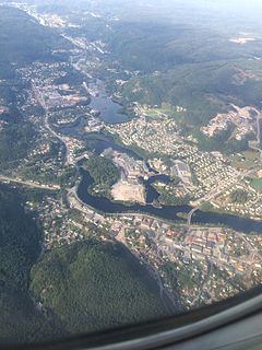
Vennesla is the administrative centre of Vennesla municipality in Vest-Agder county, Norway. The village is located in the upper Torridal valley along the river Otra, about 15 kilometres (9.3 mi) north of the city of Kristiansand. The village itself extends for about 10 kilometres (6.2 mi) along both sides of the river. The Norwegian National Road 9 passes through Mosby, about 6 kilometres (3.7 mi) south of Vennesla. The Sørlandsbanen railway line passes through Vennesla, stopping at Vennesla Station. The lake Venneslafjorden is located on the river Otra in the northern part of the village of Vennesla.


