Honeysuckle Creek Tracking Station

Last updated
Honeysuckle Creek Tracking Station
Site of Honeysuckle Creek tracking station, near Canberra, Australia.jpg
Location(s) Tennent, Australian Capital Territory, AUS
Coordinates 35°35′01″S148°58′37″E / 35.5836°S 148.977°E / -35.5836; 148.977 OOjs UI icon edit-ltr-progressive.svg
Telescope style ground station   OOjs UI icon edit-ltr-progressive.svg
Australia relief map.jpg
Red pog.svg
Location of Honeysuckle Creek Tracking Station

Honeysuckle Creek Tracking Station (Honeysuckle Creek) was a NASA Earth station in Australia near Canberra, [1] and was instrumental to the Apollo Program. The station was opened in 1967 and closed in 1981. [2]

Contents

History

Honeysuckle Creek – with a 26m dish (now relocated and decommissioned) – is renowned as the station which received and relayed to the world the first televised footage of astronaut Neil Armstrong setting foot on the Moon on 20 July 1969. Apart from television pictures, Honeysuckle Creek and Canberra Deep Space Communications Complex (Tidbinbilla) had communication and telemetry contact with the Eagle lunar and Columbia command modules. Much of this was dramatized as involving Parkes Observatory (Parkes) in the 2000 Australian film The Dish . In fact, Parkes received pictures only came into play later in the EVA. Six hours after landing, the first steps on the Moon were transmitted from Honeysuckle Creek, after an initial attempt to use the pictures from Goldstone had been hampered by operator error and poor scan conversion settings. Although the Parkes antenna was more powerful than Honeysuckle, the angle of its dish – at a lowermost pitch of 30-degrees and buffeted by wind gusts up to 100 km/h – was not in line to receive signals during the first seven minutes of the EVA. [3] Honeysuckle Creek signals were sent direct to OTC Sydney via Williamsdale and Red Hill (Canberra). [4] Working for NASA, Charlie Goodman selected the audiovisual feeds from Honeysuckle Creek and Parkes for worldwide broadcasts.

The Honeysuckle Creek and Tidbinbilla antennas were built and run by NASA, but staffed by Australians. It was the policy of the Australian Government that the director had to be a citizen or permanent resident of Australia. When Apollo missions ended in 1972, Honeysuckle Creek was redirected to the new Skylab program. As well, it was used for experiments with Apollo scientific stations placed on the Moon by astronauts.

At the end of the Skylab program in 1974, Honeysuckle Creek was connected to the Deep Space Network with the designation Deep Space Station 44. Honeysuckle Creek closed in December 1981. The 26m antenna was relocated nearby to the Canberra Deep Space Communications Complex at Tidbinbilla, and redesignated Deep Space Station 46. The Antenna was decommissioned in late 2009. In May 2010, the American Institute of Aeronautics and Astronautics declared the antenna a Historical Aerospace Site. The antenna remains in perpetuity as a historical site at Tidbinbilla. [5]

Today, at Honeysuckle Creek, the concrete foundation is the only remnant of the tracking station. An outdoor display was added in 2001. Honeysuckle Creek is considered the geographical centre of the Australian Capital Territory. [6]

Climate

The climate of Honeysuckle Creek, as to be expected of its much greater elevation, is significantly cooler than that of Canberra. Notwithstanding, its maximum temperatures are warm relative to elevation, due to the fact that it still lay on the leeward (eastern) side of the Brindabella Range.

Annually, it receives 14.4 snowy days on average. [7]

Climate data for Honeysuckle Creek (1967–1981); 1,116 m AMSL; 35.58° S, 148.98° E
MonthJanFebMarAprMayJunJulAugSepOctNovDecYear
Record high °C (°F)36.1
(97.0)
34.7
(94.5)
30.0
(86.0)
26.1
(79.0)
20.0
(68.0)
17.2
(63.0)
16.2
(61.2)
19.2
(66.6)
23.2
(73.8)
26.1
(79.0)
32.2
(90.0)
35.0
(95.0)
36.1
(97.0)
Mean daily maximum °C (°F)23.3
(73.9)
23.0
(73.4)
19.9
(67.8)
15.9
(60.6)
11.4
(52.5)
8.5
(47.3)
7.9
(46.2)
9.1
(48.4)
12.1
(53.8)
15.8
(60.4)
18.3
(64.9)
22.1
(71.8)
15.6
(60.1)
Mean daily minimum °C (°F)10.7
(51.3)
11.0
(51.8)
8.7
(47.7)
5.2
(41.4)
2.5
(36.5)
−0.1
(31.8)
−1.1
(30.0)
−0.2
(31.6)
1.5
(34.7)
4.5
(40.1)
6.4
(43.5)
8.6
(47.5)
4.8
(40.7)
Record low °C (°F)1.4
(34.5)
1.1
(34.0)
−1.0
(30.2)
−4.0
(24.8)
−6.1
(21.0)
−7.0
(19.4)
−7.8
(18.0)
−11.1
(12.0)
−6.1
(21.0)
−6.5
(20.3)
−3.3
(26.1)
−0.6
(30.9)
−11.1
(12.0)
Average precipitation mm (inches)93.0
(3.66)
104.7
(4.12)
78.2
(3.08)
88.4
(3.48)
74.6
(2.94)
58.9
(2.32)
57.9
(2.28)
92.9
(3.66)
86.9
(3.42)
112.0
(4.41)
85.2
(3.35)
67.3
(2.65)
1000
(39.37)
Average precipitation days (≥ 0.2 mm)11.410.911.19.411.411.310.913.312.713.512.08.4136.3
Source: Australian Bureau of Meteorology; Honeysuckle Creek

See also

Related Research Articles

<span class="mw-page-title-main">NASA Deep Space Network</span> Network of radio communication facilities run by NASA

The NASA Deep Space Network (DSN) is a worldwide network of spacecraft communication ground segment facilities, located in the United States (California), Spain (Madrid), and Australia (Canberra), that supports NASA's interplanetary spacecraft missions. It also performs radio and radar astronomy observations for the exploration of the Solar System and the universe, and supports selected Earth-orbiting missions. DSN is part of the NASA Jet Propulsion Laboratory (JPL).

<i>The Dish</i> 2000 Australian film

The Dish is a 2000 Australian historical comedy-drama film that tells the story of the Parkes Observatory's role in relaying live television of humanity's first steps on the Moon during the Apollo 11 mission in 1969. It was the top-grossing Australian film in 2000.

<span class="mw-page-title-main">Goldstone Deep Space Communications Complex</span> US observatory near Barstow, California

The Goldstone Deep Space Communications Complex (GDSCC), commonly called the Goldstone Observatory, is a satellite ground station located in Fort Irwin in the U.S. state of California. Operated by NASA's Jet Propulsion Laboratory (JPL), its main purpose is to track and communicate with interplanetary space missions. It is named after Goldstone, California, a nearby gold-mining ghost town.

<span class="mw-page-title-main">Parkes Observatory</span> Radio telescope observatory in New South Wales, Australia

Parkes Observatory is a radio astronomy observatory, located 20 kilometres (12 mi) north of the town of Parkes, New South Wales, Australia. It hosts Murriyang, the 64 m CSIRO Parkes Radio Telescope also known as "The Dish", along with two smaller radio telescopes. The 64 m dish was one of several radio antennae used to receive live television images of the Apollo 11 Moon landing. Its scientific contributions over the decades led the ABC to describe it as "the most successful scientific instrument ever built in Australia" after 50 years of operation.

<span class="mw-page-title-main">Canberra Deep Space Communication Complex</span> Interplanetary radio communication station

The Canberra Deep Space Communication Complex (CDSCC) is a satellite communication station, part of the Deep Space Network of NASA's Jet Propulsion Laboratory (JPL), located at Tidbinbilla in the Australian Capital Territory. Opened in 1965, the complex was used for tracking the Apollo Lunar Module, and along with its two sister stations at Goldstone, California and Madrid, Spain is now used for tracking and communicating with NASA's spacecraft, particularly interplanetary missions. Its DSS-43 antenna is the only antenna on Earth that can send commands to Voyager 2. It is managed in Australia by the Commonwealth Scientific and Industrial Research Organisation (CSIRO) for NASA’s Space Communications and Navigation program (SCaN) at NASA Headquarters in Washington, D.C.

<span class="mw-page-title-main">Madrid Deep Space Communications Complex</span> Radio telescope

The Madrid Deep Space Communications Complex (MDSCC), in Spanish and officially Complejo de Comunicaciones de Espacio Profundo de Madrid, is a satellite ground station located in Robledo de Chavela, Spain, and operated by the Instituto Nacional de Técnica Aeroespacial (INTA). Part of the Deep Space Network (DSN) of NASA's Jet Propulsion Laboratory (JPL), along with its two sister stations at Goldstone, California and Canberra, Australia it is used for tracking and communicating with NASA's spacecraft, particularly interplanetary missions. The DSN and the Near Space Network (NSN) are services of the NASA Space Communications and Navigation program (SCaN).

<span class="mw-page-title-main">Andrew Tink</span> New South Wales politician

Andrew Arnold Tink AM is a former Australian politician, having served as a member of the New South Wales Legislative Assembly for the Liberal Party from 1988 to 2007. He was in the shadow cabinet from 1995 until March 2006. He has written two political biographies, a third book on the events and political consequences of a fatal plane crash, a fourth on Australian history, culture and society in the 20th century and a fifth on the involvement of Honeysuckle Creek Tracking Station in the first Moon landing. Since leaving politics, Tink has been appointed a visiting fellow and adjunct professor at Macquarie University, as a trustee of the Historic Houses Trust of New South Wales and president of the Library Council of New South Wales. He is an honorary Doctor of Letters honoris causa from Macquarie University.

<span class="mw-page-title-main">Maspalomas Station</span> Radio antenna ground station in Spain

Maspalomas Station is an INTA-operated, ESTRACK radio antenna ground station for communication with spacecraft located at the southern area of Gran Canaria island, on the INTA campus. It is situated on the Montaña Blanca hill and is visible from the coastal resort of Meloneras, close to Maspalomas. It was originally established in the 1960s to support NASA's nascent human spaceflight program.

<span class="mw-page-title-main">Orroral Valley Tracking Station</span>

The Orroral Valley tracking station was an Earth station in Australia, supported Earth-orbiting satellites, as part of NASA's Spacecraft Tracking and Data Acquisition Network (STADAN). It was located approximately 50 km south of Canberra, Australian Capital Territory (ACT), and was one of three tracking stations in the ACT, and seven in Australia.

<span class="mw-page-title-main">Island Lagoon Tracking Station</span>

The Island Lagoon Tracking Station, an Earth station in Australia, was the first deep space station to be established outside of the United States, near Woomera, South Australia in November 1960.

<span class="mw-page-title-main">Carnarvon Tracking Station</span> Former tracking station in Western Australia

The Carnarvon Tracking Station was an Earth tracking station in Australia, located 10 kilometres south of Carnarvon, Western Australia. It operated from 1963 until 1975, during which it supported the Gemini, Apollo and Skylab space programs.

<span class="mw-page-title-main">Apollo 11 missing tapes</span> Lost NASA telemetry data tapes

The Apollo 11 missing tapes were those that were recorded from Apollo 11's slow-scan television (SSTV) telecast in its raw format on telemetry data tape at the time of the first Moon landing in 1969 and subsequently lost.

<span class="mw-page-title-main">Third-party evidence for Apollo Moon landings</span> Independent confirmations of Apollo Moon landings

Third-party evidence for Apollo Moon landings is evidence, or analysis of evidence, about the Moon landings that does not come from either NASA or the U.S. government, or the Apollo Moon landing hoax theorists. This evidence provides independent confirmation of NASA's account of the six Apollo program Moon missions flown between 1969 and 1972.

<span class="mw-page-title-main">Jamesburg Earth Station</span>

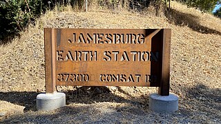
The Jamesburg Earth Station is located in the rural Cachagua area of Carmel Valley, California, about 26 miles (42 km) southeast of Monterey. It was originally built in 1968 to support the Apollo 11 Moon landing.

<span class="mw-page-title-main">OTC Satellite Earth Station Carnarvon</span> Earth station in Western Australia

The OTC Satellite Earth Station Carnarvon, an Earth station in Australia, was established to meet the need for more reliable and higher quality communications for the Apollo program. NASA contracted Australia's Overseas Telecommunications Commission (OTC) "to provide an earth station near Carnarvon, Western Australia to link the NASA tracking station in that area to the control centre in the USA", also contracting COMSAT to launch three Intelsat-2 communications satellites.

The Manned Space Flight Network was a set of tracking stations built to support the American Mercury, Gemini, Apollo, and Skylab space programs.

There are NASA facilities across the United States and around the world. NASA Headquarters in Washington, DC provides overall guidance and political leadership to the agency. There are 10 NASA field centers, which provide leadership for and execution of NASA's work. All other facilities fall under the leadership of at least one of these field centers. Some facilities serve more than one application for historic or administrative reasons. NASA has used or supported various observatories and telescopes, and an example of this is the NASA Infrared Telescope Facility. In 2013 a NASA Office of the Inspector General's (OIG) Report recommended a Base Realignment and Closure Commission (BRAC) style organization to consolidate NASA's little used facilities. The OIG determined at least 33 of NASA's 155 facilities were underutilized.

<span class="mw-page-title-main">History of the Deep Space Network</span> Observatory

The forerunner of the Deep Space Network was established in January 1958, when JPL, then under contract to the U.S. Army, deployed portable radio tracking stations in Nigeria, Singapore, and California to receive telemetry and plot the orbit of the Army-launched Explorer 1, the first successful U.S. satellite.

Thomas Reid MBE was the director of the Honeysuckle Creek Tracking Station outside Canberra, Australia, which in July 1969 transmitted live television of Neil Armstrong stepping onto the Moon to a world-wide audience of 600 million people.

<span class="mw-page-title-main">Deakin Telephone Exchange</span> Telephone exchange in Canberra, Australia

The Deakin Telephone Exchange is an exchange established in 1965, the bottom floor of which was used in the NASA Communications Network (NASCOM) until 1988, when the Canberra Deep Space Communication Complex took over its role.

References

  1. "Google Maps". Google Maps.
  2. Mackellar, Colin (10 April 2010). "A Tribute to Honeysuckle Creek Tracking Station" . Retrieved 23 April 2010.
  3. 1 2 Tink, A. A. (Andrew A.) (2018), Honeysuckle Creek : the story of Tom Reid, a little dish and Neil Armstrong's first step, NewSouth Publishing, ISBN   978-1-74223-608-7
  4. "Diagram". honeysucklecreek.net. Retrieved 22 October 2019.
  5. "AustraliaHistoricalSite" (PDF). American Institute of Aeronautics and Astronautics. Archived from the original (PDF) on 11 July 2010. Retrieved 18 July 2010.
  6. Australia, c\=AU\;o\=Australia Government\;ou\=Geoscience (15 May 2014). "Centre of Australia States and Territories". www.ga.gov.au.{{cite web}}: CS1 maint: multiple names: authors list (link)
  7. "Untitled Document".