
Dhilba Guuranda–Innes National Park, formerly Innes National Park, is an IUCN-designated protected area in the Australian state of South Australia located on the southwest tip of Yorke Peninsula about 300 kilometres (190 mi) west of the state capital of Adelaide. It is a popular destination for camping, bushwalking, fishing, surfing and scuba diving.

Port Macquarie is a coastal town in the local government area of Port Macquarie-Hastings. It is located on the Mid North Coast of New South Wales, Australia, about 390 km (242 mi) north of Sydney, and 570 km (354 mi) south of Brisbane. The town is located on the Tasman Sea coast, at the mouth of the Hastings River, and at the eastern end of the Oxley Highway (B56). The town with its suburbs had a population of 47,973 in June 2018.

Glen Innes is a parish and town on the Northern Tablelands, in the New England region of New South Wales, Australia. It is the centre of the Glen Innes Severn Shire Council. The town is located at the intersection of the New England Highway and the Gwydir Highway. At the 2016 census, Glen Innes had a population of 6,155.

The Hills Shire is a local government area in the Greater Western Sydney region of Sydney, New South Wales, Australia. The suburb is north-west of the Sydney central business district, and encompasses 401 square kilometres (155 sq mi) stretching from the M2 Hills Motorway in the south to Wiseman's Ferry on the Hawkesbury River in the north. The Hills Shire had a population of 157,243 as at the 2016 census.
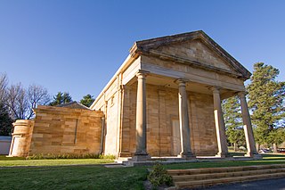
Berrima is a historic village in the Southern Highlands of New South Wales, Australia, in Wingecarribee Shire. The village, once a major town, is located on the Old Hume Highway between Sydney and Canberra. It was previously known officially as the Town of Berrima. It is close to the three major towns of the Southern Highlands: Mittagong, Bowral and Moss Vale.
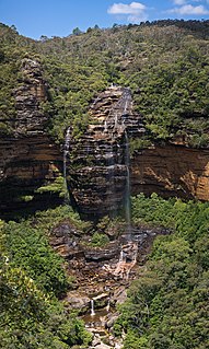
Wentworth Falls is a town in the Blue Mountains region of New South Wales, situated approximately 100 kilometres (62 mi) west of the Sydney central business district, and about 8 kilometres (5.0 mi) east of Katoomba, Australia on the Great Western Highway, with a Wentworth Falls railway station on the Main Western line. The town is at an elevation of 867 metres (2,844 ft) AHD . At the 2016 census, Wentworth Falls had a population of 6,076.

Broulee is a town on the south coast of New South Wales between Batemans Bay and Moruya. At the 2016 census, the town had a population of 1,717. Just off the beach is Broulee Island, currently joined to the mainland, but in past years the connecting spit has been covered by water, at times a very deep navigable channel with a strong current.

Guyra is a town situated midway between Armidale and Glen Innes on the Northern Tablelands in the New England region of New South Wales, Australia. It is within Armidale Regional Council and at the 2016 census, it had a population of 1,983.
Kensington is a suburb of Adelaide, South Australia in the City of Norwood, Payneham & St Peters council area. Unlike the rest of the city, Kensington's streets are laid out diagonally. Second Creek runs through and under part of the suburb, which contains many heritage buildings as well as Norwood Swimming Pool.

Port Macquarie-Hastings Council is a local government area in the Mid North Coast region of New South Wales, Australia.

Nambucca Heads is a town on the Mid North Coast of New South Wales, Australia in the Nambucca Valley. It is located on a ridge, north of the estuary of the Nambucca River near the Pacific Highway. Its 2011 population was 6,137, including 602 (9.7%) indigenous persons and 5,180 (83.3%) Australian-born persons in the Shire. The place name is derived from an Gumbaynggirr word Ngambagabaga. Clement Hodgkinson asked two Ngamba men what the name of the area was they responded to Nyambagabaga as the spot they were standing was a bend in the river where a Ngamba giant was speared in the leg in the Dreaming. This location is the Foreshore Caravan Park now. Ngamba is a subsection of Gumbaynggirr Nation & Baga Baga means Knee. This was later interpreted as Nambucca. It is a popular holiday and retirement destination.

Willow Tree is a village composed of about 308 people, located in New South Wales, Australia. It is situated in the Liverpool Plains, 14 kilometres south of Quirindi near the junction of the Kamilaroi and New England Highways. The town itself is small but the farms extend southwest out to the township of Warrah. It is a service centre to the rural areas of Warrah and Mount Parry.

Ben Lomond is a village on the Northern Tablelands in the New England region of New South Wales, Australia. The village is situated 6 km off the New England Highway between Armidale and Glen Innes. It was located in the Guyra Shire local government area until that council was amalgamated into the Armidale Regional Council on 12 May 2016, with parts of the surrounding district in Glen Innes Severn Shire and Inverell Shire. It is primarily a farming area, with most of the residents involved in sheep, cattle and grain farming.

Mathoura is a small town in the Riverina region of southern New South Wales, Australia, in the Murray River Council local government area. At the 2016 census, Mathoura had a population of 938. The town's name is derived from an aboriginal word for 'windy'.

Glen Innes Severn is a local government area in the New England region of New South Wales, Australia. The council serves an area of 5,487 square kilometres (2,119 sq mi) and is located adjacent to the New England Highway. The council was formed by the amalgamation of Severn Shire and Glen Innes City Council.

Cape Spencer is a headland in the Australian state of South Australia located on the south west tip of Yorke Peninsula in the gazetted locality of Inneston. It was named after George Spencer, 2nd Earl Spencer by Matthew Flinders during March 1802. It has been the site of an operating navigation aid since 1950 and has been located within the Innes National Park since 1970.
Wellingrove is a village located on the Wellingrove Road about 20 kilometres (12 mi) north west of Glen Innes, New South Wales on the Northern Tablelands, New South Wales, Australia. At the 2006 census, Wellingrove had a population of 113.

Leyburn is a rural town in the Southern Downs Region and a locality split between the South Downs Region and the Toowoomba Region in Queensland, Australia. In the 2016 census, Leyburn had a population of 476 people.
Middle Island is an island in the Australian state of South Australia located in Spencer Gulf within Pondalowie Bay on the south-western coast of Yorke Peninsula. It is the largest of three islands within the bay with an approximate area of 28 hectares. It first obtained protected area status as a fauna conservation reserve declared under the Crown Lands Act 1929-1966 on 16 March 1967 and is currently located within the boundaries of the Innes National Park. It is also located within a habitat protection zone of the Southern Spencer Gulf Marine Park. DEWNR lists the islands as 'no access' areas for the general public.
Wallerberdina Station, most commonly known simply as Wallerberdina, is a pastoral lease that operates as a cattle station in South Australia.
