
Powys is a county and preserved county in Wales. It borders Gwynedd, Denbighshire, and Wrexham to the north; the English ceremonial counties of Shropshire and Herefordshire to the east; Monmouthshire, Blaenau Gwent, Merthyr Tydfil, Caerphilly, Rhondda Cynon Taf, and Neath Port Talbot to the south; and Carmarthenshire and Ceredigion to the west. The largest settlement is Newtown, and the administrative centre is Llandrindod Wells.

Caergwrle is a village in the county of Flintshire, in north east Wales. Approximately 5–6 miles (8.0–9.7 km) from Wrexham and situated on the A541 road, it is contiguous with the villages of Abermorddu and Hope, though in parts Caergwrle and Hope are separated by a river border. The village lies on the River Alyn and sits at the base of Hope Mountain. At the 2001 Census, the population was 1,650. The population was subsequently absorbed in the community of Hope and only the electoral ward remained. The population of this ward as taken at the 2011 census was 1,619. The ward includes the area of Abermorddu. Further south is the village of Cefn-y-Bedd.

Abergwyngregyn is a village and community of historical note in Gwynedd, a county and principal area in Wales. Under its historic name of Aber Garth Celyn it was the seat of Llywelyn ap Gruffudd. It lies in the historic county of Caernarfonshire.

Mynydd Isa is a village in Flintshire, in north-east Wales. It lies between the county town of Mold, and Buckley in the community of Argoed which had a population of 5837 according to the 2011 census. Mynydd Isa was originally a small hamlet on the north side of the Mold to Buckley road just downhill from the now demolished Calvinist chapel. It did not appear on Ordnance Survey maps until 1912.

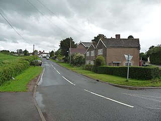
Hope is a small village and community in Flintshire, north-east Wales. The village is located approximately 3 miles / 4.5 km from the Wales-England border, on the course of the River Alyn, and less than 5 miles from Wrexham.

Sarn Helen refers to several stretches of Roman road in Wales. The 160-mile (260 km) route, which follows a meandering course through central Wales, connects Aberconwy in the north with Carmarthen in the west. Despite its length, academic debate continues as to the precise course of the Roman road. Many sections are now used by the modern road network while other parts are still traceable. However, there are sizeable stretches that have been lost and are unidentifiable.
Monmouthshire County Council is the governing body for the Monmouthshire principal area – one of the unitary authorities of Wales.
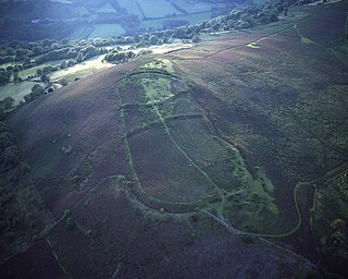
The rectangular enclosure that defined this Roman fort was built in the 70s AD as part of the campaign to integrate southern Wales into the Roman province of Britannia Superior. It lay on a key road, now known as the Sarn Helen (RR69), from the legionary fortress of Isca Augusta (Caerleon) that ran north west across Wales to Bremia and on to North Wales. It also sat on a road running from Moridunum (Carmarthen) across to eastern Wales at Castell Collen. It thus held an important crossroads along with a bridging point over the River Towy, and the town that grew up near the fort retained its significance and became Llandovery.

Cefn-y-bedd is a village in Flintshire, north-east Wales.

Craig yr Aderyn, also known as Bird's Rock, is a hill rising to a height of 258 metres (846 ft) above sea level on the south bank of the River Dysynni near Llanfihangel-y-Pennant in the county of Gwynedd, north-west Wales. Craig yr Aderyn has been designated as a Site of Special Scientific Interest because of the choughs and other birds that breed there.

Bryn Arw is a hill in the Black Mountains of the Brecon Beacons National Park in Monmouthshire, south Wales. It lies 4 km north of the town of Abergavenny and 1.5 miles west of the village of Llanvihangel Crucorney. Its summit at 384m above sea level is the more northerly of two tops which lie on the crest of a slightly arcuate north-south ridge which drops away to the south at first gently and then sharply. The hill is isolated from the main mass of the range by the valleys of Cwm Coed-y-cerig to the north and by Cwm Brynarw to the west. It is a Marilyn.
Gaer is the name of a hill in the Black Mountains of the Brecon Beacons National Park in Monmouthshire, south Wales. It lies at the southern end of the long ridge between the valley of the Grwyne Fawr and the Vale of Ewyas one mile to the north of Bryn Arw and 3 miles northeast of Sugarloaf. Its summit at 427m above sea level sits within an Iron Age hillfort known as Twyn y Gaer.

Moel y Gamelin is a hill in Denbighshire, North Wales, to the northwest of the town of Llangollen. It is the highest summit of a range which stretches eastwards from near the village of Carrog to the Horseshoe Pass traversed by the A542 road, and reaches an elevation of 577 metres (1,893 ft) above sea level. The western part of the range is known as Llantysilio Mountain whilst the eastern end is referred to as Maesyrchen Mountain. At its top is a round cairn, of unknown date, measuring about 30 metres (100 ft) in diameter and 1.8 metres (6 ft) high. It is in the Clwydian Range and Dee Valley Area of Outstanding Natural Beauty.

St Caian's Church, Tregaian, also known as St Caean's Church, Tregaean, is a small medieval church dating from the 14th century in Anglesey, north Wales. It is dedicated to St Caian, a Christian from the 5th or 6th century about whom little is known. The building contains a late 14th-century east window and a late 15th-century doorway. The churchyard contains the grave of William ap Howel, who died in 1581 at the age of 105, leaving over forty children between the ages of 8 and 89 and over three hundred living descendants.

Blaenffos is a small village of around 200 inhabitants in the north of Pembrokeshire, Wales, in the community of Boncath. It sits on the boundary between the former parishes of Llanfihangel Penbedw and Castellan Chapelry.
Monmouth Cap is a hamlet in the north of the county of Monmouthshire, Wales. It stands to the north of the village of Grosmont, and to the south of the village of Pontrilas, just over the border in England.

Crosskeys is a village, community and an electoral ward in Caerphilly county borough in Wales.

Braich-y-Dinas was an extensive hillfort at the summit of Penmaenmawr, one of the northernmost peaks of the Carneddau mountain range on North coast of Wales. It was once considered the best preserved and most complete hillfort in North-West Wales, but completely disappeared in the first half of the 20th century due to a massive quarrying effort by the Darbishire family, which overwhelmed and eventually destroyed all traces of it, despite efforts by the Royal Commission to save the site.

Bryn-henllan, Bryn Henllan or Brynhenllan is a small settlement in the community of Dinas Cross, north Pembrokeshire, Wales, just north of the A487 road between Fishguard and Newport, on the road leading to Pwllgwaelod.
