The Weald is an area of South East England between the parallel chalk escarpments of the North and the South Downs. It crosses the counties of Hampshire, Surrey, West Sussex, East Sussex, and Kent. It has three parts, the sandstone "High Weald" in the centre, the clay "Low Weald" periphery and the Greensand Ridge, which stretches around the north and west of the Weald and includes its highest points. The Weald once was covered with forest and its name, Old English in origin, signifies "woodland". The term is still used, as scattered farms and villages sometimes refer to the Weald in their names.

Weald Clay or the Weald Clay Formation is a Lower Cretaceous sedimentary rock unit underlying areas of South East England, between the North and South Downs, in an area called the Weald Basin. It is the uppermost unit of the Wealden Group of rocks within the Weald Basin, and the upper portion of the unit is equivalent in age to the exposed portion of the Wessex Formation on the Isle of Wight. It predominantly consists of thinly bedded mudstone. The un-weathered form is blue/grey, and the yellow/orange is the weathered form, it is used in brickmaking.

The Greensand Ridge, also known as the Wealden Greensand, is an extensive, prominent, often wooded, mixed greensand/sandstone escarpment in south-east England. Forming part of the Weald, a former dense forest in Sussex, Surrey and Kent, it runs to and from the East Sussex coast, wrapping around the High Weald and Low Weald. It reaches its highest elevation, 294 metres (965 ft), at Leith Hill in Surrey—the second highest point in south-east England, while another hill in its range, Blackdown, is the highest point in Sussex at 280 metres (919 ft). The eastern end of the ridge forms the northern boundary of Romney Marsh.

Sussex is a historic county and cultural region in the south of England corresponding roughly in area to the ancient Kingdom of Sussex. It is bounded on the north by Surrey, north-east by Kent, south by the English Channel, and west by Hampshire, and is divided for local government into West Sussex and East Sussex and the city of Brighton and Hove. The city of Brighton & Hove was created a unitary authority in 1997, and was granted City status in 2000. Until then Chichester had been Sussex's only city. By convention, Chichester is Sussex's capital city and Lewes is Sussex's county town.

Lower Dicker is a 0.1-hectare (0.25-acre) geological Site of Special Scientific Interest west of Hailsham in East Sussex. It is a Geological Conservation Review site.
Sussex Marble is a fossiliferous freshwater limestone material which is prevalent in the Weald Clay of parts of Kent, East Sussex and West Sussex in southeast England. It is also called Petworth Marble, Bethersden Marble or Laughton Stone in relation to villages where it was quarried, and another alternative name is winklestone. It is referred to as "marble" as it polishes very well, although it is not a true marble, geologically speaking, as it has not been subject to metamorphism. The matrix is made up of the shells of freshwater gastropods and viviparus winkles, similar to but larger than those making Purbeck Marble. The pale calcified remains of the shells are in a matrix of darker material. West Sussex has a good concentration of thin layers of Sussex Marble; beds typically measure no more than 1 foot (0.30 m) thick. There are often two beds—the lower formed of smaller-shelled gastropods than the upper—with a layer of calcareous clay between them.
St Leonard's Forest is at the western end of the Wealden Forest Ridge which runs from Horsham to Tonbridge, and is part of the High Weald Area of Outstanding Natural Beauty. It lies on the ridge to the south of the A264 between Horsham and Crawley with the villages of Colgate and Lower Beeding within it. The A24 lies to west and A23 to the East and A272 through Cowfold to the south. Much has been cleared, but a large area is still wooded. Forestry England has 289 ha. which is open to the public, as are Owlbeech and Leechpool Woods to the east of Horsham, and Buchan Country Park to the SW of Crawley. The rest is private with just a few public footpaths and bridleways. Leonardslee Gardens were open to the public until July 2010 and re-opened in April 2019. An area of 85.4 hectares is St Leonards Forest Site of Special Scientific Interest.

The Lower Greensand Group is a geological unit present across large areas of Southern England. It was deposited during the Aptian and Albian ages of the Early Cretaceous. It predominantly consists of sandstone and unconsolidated sand that were deposited in shallow marine conditions.

The geology of East Sussex is defined by the Weald–Artois anticline, a 60 kilometres (37 mi) wide and 100 kilometres (62 mi) long fold within which caused the arching up of the chalk into a broad dome within the middle Miocene, which has subsequently been eroded to reveal a lower Cretaceous to Upper Jurassic stratigraphy. East Sussex is best known geologically for the identification of the first dinosaur by Gideon Mantell, near Cuckfield, to the famous hoax of the Piltdown Man near Uckfield.
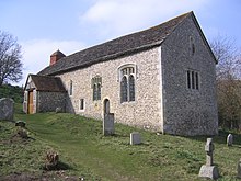
North Stoke Church, rededicated in 2007 to St Mary the Virgin after its medieval dedication was unexpectedly rediscovered, is a former Church of England parish church in the riverside hamlet of North Stoke in the Horsham District of West Sussex. The partly 11th-century cruciform building, set in an almost deserted village in a loop of the River Arun, is mostly unrestored and stands on an ancient earthwork which has pre-Christian origins. The building has architectural features and internal fittings spanning hundreds of years, including some very old stained glass and wall paintings, although there are few memorials compared with other Sussex churches of a similar age. The church, "movingly eloquent of centuries of remote Sussex agricultural life", is no longer used for worship: it was declared redundant in 1992, after which it was entrusted to the Churches Conservation Trust. English Heritage lists the church at Grade I for its architectural and historical importance.

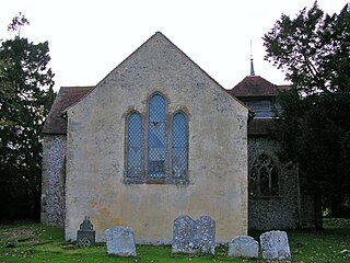
Greatham Church is the Anglican parish church of the hamlet of Greatham in the district of Horsham, one of seven local government districts in the English county of West Sussex. The tiny single-room building has been described variously as "delightful" and "one of the most appealing churches in Sussex". The unrestored 12th-century stone church serves a rural area near the River Arun and sits apart from the hamlet next to the ancient manor house. The church is a Grade I Listed building.

The Tunbridge Wells Sand Formation is a geological unit which forms part of the Wealden Group and the uppermost and youngest part of the unofficial Hastings Beds. These geological units make up the core of the geology of the Weald in the English counties of West Sussex, East Sussex and Kent.

The Ashdown Formation is a geological unit, which forms part of the Wealden Group and the lowermost and oldest part of the now unofficial Hastings Beds. These geological units make up the core of the Weald in the English counties of East Sussex and Kent.

The Wadhurst Clay Formation is a geological unit which forms part of the Wealden Group and the middle part of the now unofficial Hastings Beds. These geological units make up the core of the geology of the High Weald in the English counties of West Sussex, East Sussex and Kent.
The geology of West Sussex in southeast England comprises a succession of sedimentary rocks of Cretaceous age overlain in the south by sediments of Palaeogene age. The sequence of strata from both periods consists of a variety of sandstones, mudstones, siltstones and limestones. These sediments were deposited within the Hampshire and Weald basins. Erosion subsequent to large scale but gentle folding associated with the Alpine Orogeny has resulted in the present outcrop pattern across the county, dominated by the north facing chalk scarp of the South Downs. The bedrock is overlain by a suite of Quaternary deposits of varied origin. Parts of both the bedrock and these superficial deposits have been worked for a variety of minerals for use in construction, industry and agriculture.

A ledger stone or ledgerstone is an inscribed stone slab usually laid into the floor of a church to commemorate or mark the place of the burial of an important deceased person. The term "ledger" derives from the Middle English words lygger, ligger or leger, themselves derived from the root of the Old English verb liċġan, meaning to lie (down). Ledger stones may also be found as slabs forming the tops of tomb chest monuments.

The Upper Greensand Formation is a Cretaceous formation of Albian to Cenomanian in age, found within the Wessex Basin and parts of the Weald Basin in southern England. It overlies the Gault Clay and underlies the Chalk Group. It varies in thickness from zero to 75 m. It is predominantly a glauconitic fine-grained sandstone, locally becoming silty. Fragmentary dinosaur remains, such as those assigned to Iuticosaurus, have been recovered from this formation. It has been quarried as a building stone from Roman times, and used in London and the area of its outcrop from Devon to East Sussex.

Slinfold Stream and Quarry is a 2.3-hectare (5.7-acre) geological Site of Special Scientific Interest west of Horsham in West Sussex. It is a Geological Conservation Review site.

Warnham SSSI is a 28.5-hectare (70-acre) geological Site of Special Scientific Interest north of Horsham in West Sussex. It is a Geological Conservation Review site.
The geology of the South Downs National Park in South East England comprises a gently folded succession of sedimentary rocks from the Cretaceous and early Palaeogene periods overlain in places by a range of superficial deposits from the last 2.6 million years. Whereas the South Downs are formed from the Late Cretaceous age chalk, the South Downs National Park extends into the Weald to the north of the range and thereby includes older rock strata dating from the Early Cretaceous including sandstones and mudstones. The youngest solid rocks are found on the southern fringes of the National Park in the eastern extension of the Hampshire Basin and include sand, silt and clay deposited during the Palaeocene and Eocene epochs.