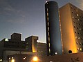
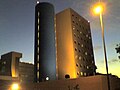
Hospital Angeles Tijuana is a is a mixed-useskyscraper and prominent fixture in Tijuana, Mexico. It serves as the primary hospital of Tijuana. The building includes office space as well as the main hospital which is located within a complex composed of another building, a 5-story tower, which on its roof has a heliport, being the first hospital in the city with such a feature.
The Hospital Angeles Tijuana offers a range of medical treatments across various specialties. These include cancer treatment, orthopedics, general surgery, and weight loss surgery.[1]
San Ysidro is a district of San Diego, California, immediately north of the Mexico–United States border. It neighbors Otay Mesa West to the north, Otay Mesa to the east, and Nestor and the Tijuana River Valley to the west; together these communities form South San Diego, a practical exclave of the City of San Diego. Major thoroughfares include Beyer Boulevard and San Ysidro Boulevard.
Federal Highway 1 is a free (libre) part of the federal highway corridors of Mexico, and the highway follows the length of the Baja California Peninsula from Tijuana, Baja California, in the north to Cabo San Lucas, Baja California Sur, in the south. The road connects with Via Rapida, which merges into the American Interstate 5 (I-5) at the San Ysidro Port of Entry, which crosses the international border south of San Ysidro, California.
Avenida Revolución is the tourist center in Tijuana, Baja California, México. It is a main thoroughfare of the historic downtown Tijuana, officially called Zona Centro, which forms part of the Delegación Centro or Central Borough of Tijuana.
San Diego–Tijuana is an international transborder agglomeration, straddling the border of the adjacent North American coastal cities of San Diego, California, United States, and Tijuana, Baja California, Mexico. The 2020 population of the region was 5,456,577, making it the largest bi-national conurbation shared between the United States and Mexico, and the second-largest shared between the US and another country. The conurbation consists of San Diego County, in the United States and the municipalities of Tijuana, Rosarito Beach (126,980), and Tecate (108,440) in Mexico. It is the third most populous region in the California–Baja California region, smaller only than the metropolitan areas of Greater Los Angeles and the San Francisco Bay Area.
Arrowhead Regional Medical Center (ARMC) is a teaching hospital located in Colton, California, within Southern California's Inland Empire. ARMC is owned and operated by the County of San Bernardino. The emergency department (ED) at ARMC is the second busiest ED in the state of California. The hospital operates ten different residency training programs.
Naval Base Coronado (NBC) is a consolidated Navy installation encompassing eight military facilities stretching from San Clemente Island, located 70 miles west of San Diego, California, in Los Angeles County, California, to the Mountain Warfare Training Camp Michael Monsoor and Camp Morena, located 60 miles east of San Diego.
The Tijuana Cultural Center (CECUT) is a cultural center in the Zona Río district of Tijuana, Mexico. The center opened 20 October 1982, and accommodates more than a million visitors per year.
St. Jude Medical Center is a faith-based, not-for-profit hospital, located in Fullerton, California, which was established by the Sisters of St. Joseph of Orange in 1957.
Centro Médico Excel, or Hospital Excel is a mixed-use skyscraper in Tijuana, Mexico. One of the prominent buildings in the city, it is the 11th tallest building in Tijuana.
The following radio stations broadcast on AM frequency 690 kHz: 690 AM is a Canadian and Mexican clear-channel frequency. CKGM Montreal and XEWW Tijuana share Class A status of 690 kHz.
The following radio stations broadcast on AM frequency 1090 kHz: 1090 AM is a United States and Mexican clear-channel frequency. KAAY Little Rock, WBAL Baltimore and XEPRS-AM Rosarito-Tijuana share Class A status on 1090 AM.
The Plaza Monumental de Tijuana, and popularly known in English as the Bullring by the Sea, is a bullring in Tijuana, Baja California, Mexico. Its opening was held on June 26, 1960. The stadium holds 21,621 people. In addition to bullfighting, the bullring frequently hosts boxing matches, concerts, cultural, and sporting events. It is located just 60 meters from the Mexico–United States border and one block from the Pacific Ocean.
Tijuana River National Estuarine Research Reserve is a natural reserve in Imperial Beach, California, and San Ysidro, San Diego. It encompasses the Tijuana River Estuary, located on the Mexico–United States border. It is divided into two parts: the Tijuana Slough National Wildlife Refuge on the north, and Border Field State Park in the south.
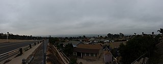
The Tijuana River Valley is a rural community in the southern section of San Diego, California. It neighbors Imperial Beach to the north and west, Egger Highlands and Nestor to the north, San Ysidro to the east, and the Mexico–United States border to the south. Major thoroughfares include Hollister Street, Monument Road, and Dairy Mart Road.
The International Wastewater Treatment Plant (IWTP) is a plant developed by the International Boundary and Water Commission (IBWC) in the South Bay area of San Diego, California. Construction began on a 75-acre site, west of San Ysidro in the Tijuana River Valley. The project, authorized by the U.S. Congress in 1989 and formally agreed between the two countries in July 1990, was part of a regional approach to solve long-standing problems, particularly the flow of sewage-contaminated water into the ocean via the Tijuana River.
Tijuana River Mouth State Marine Conservation Area (SMCA) is a marine protected area that extends offshore of southern San Diego County on California's south coast. The SMCA covers 2.91 square miles (7.5 km2).
Dorian's was a department store chain based in Tijuana, Baja California, Mexico.
Rancho Tía Juana, or Ti Juan was a land grant made to Santiago Arguello on March 4, 1829, by Governor José María de Echeandía. It covered 26,019.53 acres in what is now Tijuana in the Tijuana Municipality of Baja California, Mexico and parts of San Ysidro and the Tijuana River Valley, San Diego in South San Diego in San Diego County, California.
Plaza Viva Tijuana is an open-air shopping center in the Empleados Federales neighborhood of Tijuana, located immediately across Frontera Street from what was, until 2012, the entrance to Mexico for all pedestrians crossing from the U.S. side of the San Ysidro of the border. It houses numerous pharmacies targeted at U.S. customers, handicraft and souvenir shops, restaurants, and one of Tijuana's largest gay nightclubs.
Caesar's is a restaurant inside a hotel of the same name on Avenida Revolución in Tijuana, Mexico. The restaurant is best known for originating the Caesar salad.
This page is based on this Wikipedia article Text is available under the CC BY-SA 4.0 license; additional terms may apply. Images, videos and audio are available under their respective licenses.