
Yosemite National Park is a national park in California. It is bordered on the southeast by Sierra National Forest and on the northwest by Stanislaus National Forest. The park is managed by the National Park Service and covers 759,620 acres in four counties – centered in Tuolumne and Mariposa, extending north and east to Mono and south to Madera. Designated a World Heritage Site in 1984, Yosemite is internationally recognized for its granite cliffs, waterfalls, clear streams, groves of giant sequoia, lakes, mountains, meadows, glaciers, and biological diversity. Almost 95 percent of the park is designated wilderness. Yosemite is one of the largest and least fragmented habitat blocks in the Sierra Nevada.
Yosemite Valley is a glacial valley in Yosemite National Park in the western Sierra Nevada mountains of Central California, United States. The valley is about 7.5 mi (12.1 km) long and 3,000–3,500 ft (910–1,070 m) deep, surrounded by high granite summits such as Half Dome and El Capitan, and densely forested with pines. The valley is drained by the Merced River, and a multitude of streams and waterfalls flow into it, including Tenaya, Illilouette, Yosemite and Bridalveil Creeks. Yosemite Falls is the highest waterfall in North America and is a big attraction, especially in the spring, when the water flow is at its peak. The valley is renowned for its natural environment and is regarded as the centerpiece of Yosemite National Park.

Northern California is a geographic and cultural region that generally comprises the northern portion of the U.S. state of California, spanning the northernmost 48 of the state's 58 counties. Northern California in its largest definition is determined by dividing the state into two regions, the other being Southern California. The main northern population centers include the San Francisco Bay Area, the Greater Sacramento area, the Redding, California, area south of the Cascade Range, and the Metropolitan Fresno area. Northern California also contains redwood forests, along with most of the Sierra Nevada, including Yosemite Valley and part of Lake Tahoe, Mount Shasta, and most of the Central Valley, one of the world's most productive agricultural regions. Northern California is also home to Silicon Valley, the global headquarters for some of the most powerful tech and Internet-related companies in the world, including Meta, Apple, Google, and Nvidia.

The Merced River, in the central part of the U.S. state of California, is a 145-mile (233 km)-long tributary of the San Joaquin River flowing from the Sierra Nevada into the San Joaquin Valley. It is most well known for its swift and steep course through the southern part of Yosemite National Park, where it is the primary watercourse flowing through Yosemite Valley. The river's character changes dramatically once it reaches the plains of the agricultural San Joaquin Valley, where it becomes a slow-moving meandering stream.

The University of California, Merced is a public land-grant research university in Merced, California. It is one of the ten campuses in the University of California (UC) system. Established in 2005, UC Merced is the newest campus within the UC system. The primary campus is located around five miles north of Merced and sits adjacent to Lake Yosemite. The main campus is around 1,026 acres in size. Large swaths protected natural grasslands surround the university.

State Route 140 is a state highway in the U.S. state of California, 102 miles (164 km) in length. It begins in the San Joaquin Valley at Interstate 5 near Gustine, and runs east into Sierra Nevada, terminating in Yosemite National Park.

Sierra National Forest is a U.S. national forest located on the western slope of the central Sierra Nevada in California, bounded on the northwest by Yosemite National Park and on the south by Kings Canyon National Park. The forest is known for its mountain scenery and beautiful lakes. Forest headquarters are located in Clovis, California. There are local ranger district offices in North Fork and Prather.

Human habitation in the Sierra Nevada region of California reaches back 8,000 to 10,000 years ago. Historically attested Native American populations, such as the Sierra Miwok, Mono and Paiute, belong to the Uto-Aztecan and Utian phyla. In the mid-19th century, a band of Native Americans called the Ahwahnechee lived in Yosemite Valley. The California Gold Rush greatly increased the number of non-indigenous people in the region. Tensions between Native Americans and white settlers escalated into the Mariposa War. As part of this conflict, settler James Savage led the Mariposa Battalion into Yosemite Valley in 1851, in pursuit of Ahwaneechees led by Chief Tenaya. The California state military forces burned the tribe's villages, destroyed their food stores, killed the chief's sons, and forced the tribe out of Yosemite. Accounts from the Mariposa Battalion, especially from Dr. Lafayette Bunnell, popularized Yosemite Valley as a scenic wonder.

Central California is generally thought of as the middle third of the U.S. state of California, north of Southern California and south of Northern California. It includes the northern portion of the San Joaquin Valley, part of the Central Coast, the central hills of the California Coast Ranges and the foothills and mountain areas of the central Sierra Nevada.

Area codes 209 and 350 are telephone area codes in the North American Numbering Plan (NANP) for the U.S. state of California. Their service area includes Stockton, Modesto, Turlock, Merced, Winton, Atwater, Livingston, Manteca, Ripon, Tracy, Lodi, Galt, Sonora, Los Banos, San Andreas, Mariposa, and Yosemite, the northern San Joaquin Valley, and the Sierra Foothills.

Merced station is an intercity rail station located in Merced, California, United States. The station is served by seven daily round trips of the San Joaquins and is a transfer point between trains and Yosemite Area Regional Transportation System (YARTS) buses serving Yosemite National Park. Merced station has side platforms adjacent to the tracks of the BNSF Railway Stockton Subdivision.

Yosemite West is an unincorporated community and census-designated place (CDP) of resort homes located just outside the southern area of Yosemite National Park, just off Wawona Road, a continuation of State Route 41 from Fresno. It is a census-designated place (CDP), with a population of 47 as of the 2020 census. It is situated one mile (1.6 km) south of the Chinquapin intersection of Wawona Road with Glacier Point Road, at an altitude of 5,100 to 6,300 feet. The elevation reported by the USGS is 5,866 feet (1,788 m). The community is part of Henness Ridge, nearly 3,000 feet (910 m) above the southern banks of the Merced River and State Route 140 from Mariposa. Addresses in this area are shown as "Yosemite National Park, CA 95389".

El Portal is a census-designated place in Mariposa County, California, United States. It is located 11.5 miles (19 km) west-southwest of Yosemite Village, at an elevation of 1,939 feet (591 m). The population was 372 at the 2020 census, down from 474 at the 2010 census.
Berenda was an unincorporated community in Madera County, California. It is located on the north bank of Berenda Creek 3.3 miles (5.3 km) southeast of Fairmead, and 7 miles (11 km) northwest of Madera, at an elevation of 253 feet (77 m). Berenda is located on the Southern Pacific Railroad.
Bagby was an unincorporated community in Mariposa County, California. It was located on the north bank of the Merced River 9.5 miles (15 km) northeast of Hornitos, at an elevation of 830 feet. Lake McClure covers the original town site.

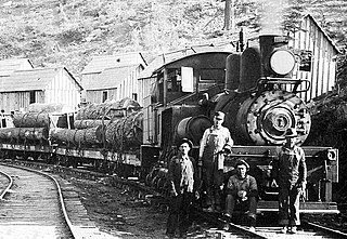
The Yosemite Valley Railroad (YVRR) was a short-line railroad that operated in California from 1907 to 1945, providing a new mode of travel and tourism for the region. It ran from Merced to the Yosemite National Park, but it did not extend to Yosemite Valley itself, as railroad construction was prohibited in the National Parks. Tourists would disembark at the park boundary in El Portal, California and stay overnight at the Hotel Del Portal before taking a stagecoach to Yosemite Valley.

The January 1997 flood of the Merced River occurred from December 31, 1996, to January 5, 1997, throughout the Yosemite Valley in Yosemite National Park, Mariposa County, California, US. The flood stands as arguably the park's worst natural disaster to date, and inarguably the worst flood in park history. The Merced River at Happy Isles peaked at 10,100 cubic feet per second during the flood. A book was written on the flood later in 1997 by Mark Goodin titled Yosemite: The 100-Year Flood. It is part of the 1997 California New Years Floods.

The Glacier Point Hotel was a historic chalet-style hotel, located at 7,240 feet (2,207 m) above sea level, the highest elevation for a hotel in the West. Constructed in 1917 in the rustic style, it was an architectural marvel with stunning views of Half Dome and Yosemite Valley. Notable for its massive fireplace, carved from a single boulder weighing over a million kilograms, the hotel was also the venue for the iconic Yosemite Firefall spectacle where burning embers were pushed off the point to create a visually stunning 'burning waterfall'. Despite its unique location and features, the hotel grappled with numerous challenges such as a short tourist season, a remote location, and water shortages. After severe damage due to heavy snowfall in the winter of 1968–69, the hotel was destroyed by an electrical fire in July 1969. Despite proposals for rebuilding, including the idea of an aerial tramway by MCA, the site eventually became subject to restrictions against commercial development. Today, remnants of the hotel's foundations remain at the site, along with a granite amphitheater and a visitor center.
The Yosemite Lumber Company was an early 20th century Sugar Pine and White Pine logging operation in the Sierra Nevada. The company built the steepest logging incline ever, a 3,100 feet (940 m) route that tied the high-country timber tracts in Yosemite National Park to the low-lying Yosemite Valley Railroad running alongside the Merced River. From there, the logs went by rail to the company’s sawmill at Merced Falls, about fifty-four miles west of El Portal.

The Telegraph Fire was a destructive wildfire in Mariposa County, Central California, in the summer of 2008. After it was unintentionally ignited by a target shooter on July 25, the fire burned 34,091 acres in the foothills of the Sierra Nevada west of Yosemite National Park before it was declared fully contained on August 6. The Telegraph Fire destroyed 20–30 homes and dozens of outbuildings and impacted tourism in the Yosemite Valley and adjacent areas. No fatalities occurred; dozens of firefighters sustained minor injuries during the fire suppression effort.


