
Posey County is the southwesternmost county in the U.S. state of Indiana. Its southern border is formed by the Ohio River, and its western border by the Wabash River, a tributary to the Ohio. As of 2020, the population was 25,222. The county seat is Mount Vernon.

Saltsburg is a borough in Indiana County, Pennsylvania, United States. Its location is in western Pennsylvania, in the southwestern corner of Indiana County near its border with Westmoreland County.

The Maumee River is a river running in the United States Midwest from northeastern Indiana into northwestern Ohio and Lake Erie. It is formed at the confluence of the St. Joseph and St. Marys rivers, where Fort Wayne, Indiana has developed, and meanders northeastwardly for 137 miles (220 km) through an agricultural region of glacial moraines before flowing into the Maumee Bay of Lake Erie. The city of Toledo is located at the mouth of the Maumee. The Maumee was designated an Ohio State Scenic River on July 18, 1974. The Maumee watershed is Ohio's breadbasket; it is two-thirds farmland, mostly corn and soybeans. It is the largest watershed of any of the rivers feeding the Great Lakes, and supplies five percent of Lake Erie's water.

The Calumet River is a system of heavily industrialized rivers and canals in the region between the south side of Chicago, Illinois, and the city of Gary, Indiana. Historically, the Little Calumet River and the Grand Calumet River were one, the former flowing west from Indiana into Illinois, then turning back east to its mouth at Lake Michigan at Marquette Park in Gary. Now the system is part of the Chicago Area Waterway System and through the use of locks flows away from Lake Michigan to the Cal-Sag Channel.

The Wabash River is a 503-mile-long (810 km) river that drains most of the state of Indiana in the United States. It flows from the headwaters in Ohio, near the Indiana border, then southwest across northern Indiana turning south near the Illinois border, where the southern portion forms the Indiana-Illinois border before flowing into the Ohio River.

The Wabash and Erie Canal was a shipping canal that linked the Great Lakes to the Ohio River via an artificial waterway. The canal provided traders with access from the Great Lakes all the way to the Gulf of Mexico. Over 460 miles long, it was the longest canal ever built in North America.

The Indiana Harbor and Ship Canal is an artificial waterway on the southwest shore of Lake Michigan, in East Chicago, Indiana, which connects the Grand Calumet River to Lake Michigan. It consists of two branch canals, the 1.25 miles (2.01 km) Lake George Branch and the 2 miles (3.2 km) long Grand Calumet River Branch which join to form the main Indiana Harbor Canal.

The city of Chicago is located in northern Illinois, United States, at the south western tip of Lake Michigan. It sits on the Saint Lawrence Seaway continental divide at the site of the Chicago Portage, an ancient trade route connecting the Mississippi River and the Great Lakes watersheds.
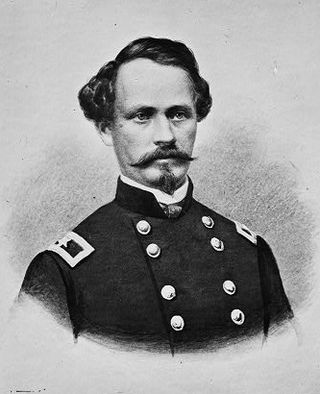
Alvin Peterson Hovey was a Union general during the American Civil War, an Indiana Supreme Court justice, congressman, and the 21st governor of Indiana from 1889 to 1891. During the war he played an important role in the Western theatre, earning high approval from General Ulysses Grant, and uncovered a secret plot for an uprising in Indiana. As governor, he launched several legal challenges to the Indiana General Assembly's removal of his powers, but was mostly unsuccessful. He successfully advocated election reform before he died in office.

State Road 69 (SR 69) is a part of the Indiana State Road system that runs between Hovey Lake Fish and Wildlife Area and Griffin in US state of Indiana. The 35.07 miles (56.44 km) of SR 69 that lie within Indiana serve as a major conduit. Some of the highway is listed on the National Highway System. Various sections are urban two-lane highway, three-lane highway and rural two-lane highway. The highway passes through residential, industrial and commercial properties.

Seneca Waterways Council (SWC) is a local council of the Boy Scouts of America that serves youth in Ontario, Wayne, Seneca, Yates, and Monroe Counties in Western New York. The current Council President is Ted Orr. The current Council Scout Executive is Stephen Hoitt.

Point Township is one of ten townships in Posey County, Indiana. As of the 2000 census, its population was 497. The lowest, the southernmost, and the westernmost points in Indiana are all located along the township's boundaries.

The Indiana Canal Company was a corporation first established in 1805 for the purpose of building a canal around the Falls of the Ohio on the Indiana side of the Ohio River. After several attempts, and possible sabotage by a supporter of the Louisville and Portland Canal, the project was ended.

Hovey Lake-Klein Archeological Site is an archaeological site of the Caborn-Welborn variant of the Mississippian culture. Hovey Lake-Klein Archeological Site is located on the west bank of Hovey Lake, a backwater lake near the Ohio River close to its confluence with the Wabash River. The site was an extensive village occupation dating between 1400 and 1650 CE.
Canal Lands were tracts of land donated by the federal government to several Great Lakes states in the 19th century to encourage internal improvements and aid in funding the construction of Canals. These states sold the land tracts to private parties to raise funds for canal construction.
The Hovey Lake Archaeological District is a historic district composed of multiple archaeological sites in the extreme southwestern corner of the U.S. state of Indiana.

The Grand Calumet River is a 13.0-mile-long (20.9 km) river that flows primarily into Lake Michigan. Originating in Miller Beach in Gary, it flows through the cities of Gary, East Chicago and Hammond, as well as Calumet City and Burnham on the Illinois side. The majority of the river's flow drains into Lake Michigan via the Indiana Harbor and Ship Canal, sending about 1,500 cubic feet (42 m3) per second of water into the lake. A smaller part of the flow, at the river's western end, enters the Calumet River, and through the Illinois ultimately drains into the Mississippi River.
Hovey is an unincorporated community in Point Township, Posey County, in the U.S. state of Indiana.

