
Arequipa is a department in southwestern Peru. It is bordered by the departments of Ica, Ayacucho, Apurímac and Cusco in the north, the Department of Puno in the east, the Department of Moquegua in the south, and the Pacific Ocean in the west. Its capital, also called Arequipa, is Peru's second-largest city.

Colca Canyon is a canyon of the Colca River in southern Peru, located about 160 kilometres (99 mi) northwest of Arequipa. It is Peru's third most-visited tourist destination with about 120,000 visitors annually. With a depth of 3,270 metres (10,730 ft), it is one of the deepest in the world. The Colca Valley is a colorful Andean valley with pre-Inca roots, and towns founded in Spanish colonial times, still inhabited by people of the Collagua and the Cabana cultures. The local people maintain their ancestral traditions and continue to cultivate the pre-Inca stepped terraces, called andenes.

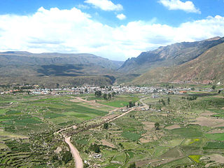
Chivay is a town in the Colca valley, capital of the Caylloma province in the Arequipa region, Peru. Located at about 12,000 ft above sea level, it lies upstream of the renowned Colca Canyon. It has a central town square and an active market. Ten km to the east, and 1,500 metres above the town of Chivay lies the Chivay obsidian source.

Caylloma Province is the largest of eight provinces in the Arequipa Region of Peru.

Colca River which downstream is called Majes and Camaná is a Peruvian river in the Arequipa Region that flows deep in the rugged Andes of southern Peru. It originates south-east of the village Janq'u Lakaya (Ancolaccaya) in the Callalli District of the Caylloma Province. On its way from Chivay to Cabanaconde it flows through one of the deepest canyons of the world known as the Colca Canyon. Near the town of Camaná the river empties into the Pacific Ocean.
Chivay District is one of twenty districts of the province Caylloma in Peru.

Surihuiri, Sorehuire or Surihuire is a 5,506-metre-high (18,064 ft) mountain in the Chila mountain range in the Andes of Peru. It is located in the Arequipa Region, Caylloma Province, in the districts Lari, Madrigal and Tapay. Surihuiri lies north of the Colca River, northwest of the mountains Mismi, Quehuisha and Jatunpila and south of Minaspata. Some of the nearest villages are Tambomayo and Surihuire.

Jello Jello (possibly from Aymara and Quechua q'illu yellow, the reduplication indicates that there is a group or a complex of something, "a complex of yellow", q'illu q'illu a plant , is a mountain in the Andes of Peru, about 5,220 metres high. It is situated in the Arequipa Region, Caylloma Province, in the districts Callalli and Chivay. Jello Jello lies northeast of a higher mountain named Huarancante. There is a small lake northwest of the mountain named Jello Jello.
Uskallaqta is an archaeological complex with stone tombs (chullpa) and rooms in Peru. It is situated in the Arequipa Region, Caylloma Province, Chivay District, southwest of Chivay.
Pukara is an archaeological site in Peru. It is located in the Arequipa Region, Caylloma Province, Coporaque District. The ruins consisting of buildings, stone tombs (chullpa), deposits (qullqa) and walls lie on the left side of the road from Chivay to Coporaque.
Pucara is a mountain in the Chila mountain range in the Andes of Peru, about 5,000 metres (16,404 ft) high. It is situated in the Arequipa Region, Caylloma Province, on the border of the districts Caylloma, Lari and Tuti. Pucara lies north-east of the mountain Mismi and east of the mountain Chuaña.
Ancachita is a mountain in the Andes of Peru, about 5,131.3 metres (16,835 ft) high. It is situated in the Arequipa Region, Caylloma Province, on the border of the districts Callalli and Chivay, east of Chivay. Ancachita lies north of the higher mountains Huarancante and Jello Jello.
Chila is a mountain in the Andes of Peru, about 5,111.2 metres (16,769 ft) high. It lies in the Arequipa Region, Castilla Province, Choco District, and in the Caylloma Province, Caylloma District. Chila is situated southeast of the lake Llocococha.
Minasnioc is a mountain in the north of the Chila mountain range in the Andes of Peru, about 5,000 metres (16,404 ft) high. It is situated in the Arequipa Region, Caylloma Province, on the border of the districts Caylloma and Tapay. It lies north of Surihuiri and Minaspata and northeast of the mountain named Huaillaccocha and Huallatane.
Jichu Qullu may refer to:
Chungara is a mountain in the Chila mountain range in the Andes of Peru, about 5,000 m (16,404 ft) high. It is located in the Arequipa Region, Caylloma Province, on the border of the districts of Caylloma and Tuti. It lies south of Jatunchungara and Mesa Chungara and northeast of Ticlla.
Jatunchungara is a 5,287-metre-high (17,346 ft) mountain in the Chila mountain range in the Andes of Peru. It is located in the Arequipa Region, Caylloma Province, on the border of the districts of Caylloma and Sibayo. It lies north of Chungara and Mesa Chungara. There is a small lake north of the mountain named Chungara.
Tiklla or Tiqlla may refer to:


