Callalli District

Last updated
Callalli
Callalli-peru-mountains-city-aerial-view.jpg
Peru location map.svg
Red pog.svg
Callalli
Location of Callalli in the Caylloma province
Coordinates: 15°30′26″S71°26′46″W / 15.5073°S 71.4462°W / -15.5073; -71.4462
Country Flag of Peru.svg  Peru
Region Arequipa
Province Caylloma
Founded1573
Capital Callalli
Government
   Mayor Florencio Josue Valdivia Mamani
Area
  Total1,485.1 km2 (573.4 sq mi)
Elevation
3,867 m (12,687 ft)
Population
  Total2,554
  Density1.7/km2 (4.5/sq mi)
Time zone UTC-5 (PET)
UBIGEO 040504
Website https://www.facebook.com/municallalli/

Callalli District is one of twenty districts of the Caylloma Province in Peru and is located within the geographical area of the Colca Canyon. [1]

Contents

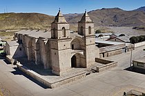
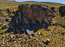
Its capital, Callalli, lies on an ancient trade route for Obsidian that ran from Chivay to Lake Titicaca around 1800-200BC. The earliest findings in the region, carvings of camelids in the Mollupunko Cave, date around 8,000 years back. [2] The town of Callalli was founded as a Spanish Reduccion in 1573 with the initial name of Alcantara de Callalli. [3] [4]

Callalli is the main seat of a catholic pastoral team that takes care of a 7,000 km² area including the towns of Callalli, Sibayo, Tisco, Imata and Caylloma. The parish is led by the Austrian priest and missionary Franz Windischhofer since 1991, whose work was acknowledged by the Peruvian government for "building a community of peace" in Peru since 1980. [5] [6]

Geography

One of the highest mountains of the district is Waran K'anthi at approximately 5,426 m (17,802 ft). Other mountains are listed below: [7]

Tourism

Ethnic groups

The people in the district are mainly indigenous citizens of Quechua descent. Quechua is the language which the majority of the population (62.06%) learnt to speak in childhood, 37.48% of the residents started speaking using the Spanish language (2007 Peru Census). [19]

Related Research Articles

<span class="mw-page-title-main">Department of Arequipa</span> First-level administrative division in southwestern Peru

Arequipa is a department and region in southwestern Peru. It is the sixth largest department in Peru, after Puno, Cuzco, Madre de Dios, Ucayali, and Loreto, its sixth most populous department, and its eleventh least densely populated department. It is bordered by the departments of Ica, Ayacucho, Apurímac and Cusco in the north, the Department of Puno in the east, the Department of Moquegua in the south, and the Pacific Ocean in the west. Its capital, also called Arequipa, is Peru's second-largest city.

<span class="mw-page-title-main">Arequipa Province</span> Province in Arequipa, Peru

Arequipa is a province in the Arequipa Region, Peru. Its capital, Arequipa, is Peru's second most populous province of Peru. It borders the provinces of Islay, Camaná, Caylloma, and the Cusco and Puno regions. According to INEI in the year 2014 it has a population of 958.351 people.

<span class="mw-page-title-main">Colca Canyon</span> Natural canyon in Peru

The Colca Canyon is a canyon of the Colca River in southern Peru, located about 160 kilometres (99 mi) northwest of Arequipa. With a depth of about 1000 - 2000 m, it is one of the deepest canyons in the world. Its length is about 70 kilometres (43 mi). The Colca Valley is a colorful Andean valley with pre-Inca rooted inhabitants, and towns founded in Spanish colonial times, still inhabited by people of the Collagua and the Cabana cultures. The local people maintain their ancestral traditions and continue to cultivate the pre-Inca stepped terraces, called andenes.

Carhuasanta is a small river located in the Arequipa Region of Peru. It is known as the headwaters of the Amazon River. The brook is fed by the winter snows of Nevado Mismi, (5,597 m), some 6,400 kilometers from the Atlantic Ocean. Of all the possible river sources in the Amazon Basin, it is the snow melt of the Carhuasanta that has been calculated by cartographers to be one of the furthermost water sources from the mouth of the Amazon.

<span class="mw-page-title-main">Chivay</span> Town in Arequipa, Peru

Chivay is a town in the Colca valley, capital of the Caylloma province in the Arequipa region, Peru. Located at about 3,600 m above sea level (12,000 ft), it lies upstream of the renowned Colca Canyon. It has a central town square and an active market. Ten km to the east, and 1,500 metres above the town of Chivay lies the Chivay obsidian source.

<span class="mw-page-title-main">Caylloma Province</span> Province in Arequipa, Peru

Caylloma Province is the largest of eight provinces in the Arequipa Region of Peru.

<span class="mw-page-title-main">Colca River</span> River in Peru

Colca River which downstream is called Majes and Camaná is a Peruvian river in the Arequipa Region that flows deep in the rugged Andes of southern Peru. It originates south-east of the village Janq'u Lakaya (Ancolaccaya) in the Callalli District of the Caylloma Province. On its way from Chivay to Cabanaconde it flows through one of the deepest canyons of the world known as the Colca Canyon. Near the town of Camaná the river empties into the Pacific Ocean.

<span class="mw-page-title-main">Choco District</span> District in Arequipa, Peru

Choco District is one of fourteen districts of the province Castilla in Peru.

<span class="mw-page-title-main">Madrigal District</span> District in Arequipa, Peru

Madrigal District is one of twenty districts of the province Caylloma in Peru.

San Antonio de Chuca District is one of twenty districts of the province Caylloma in Peru.

<span class="mw-page-title-main">Sibayo District</span> District in Arequipa, Peru

Sibayo District is one of twenty districts of the province Caylloma in Peru. It is adjacent to Callalli and crossed by the Colca River on one side.

<span class="mw-page-title-main">Tapay District</span> District in Arequipa, Peru

Tapay District is one of twenty districts of Caylloma Province in Peru.

<span class="mw-page-title-main">Tisco District</span> District in Arequipa, Peru

Tisco District is one of twenty districts of the province Caylloma in Peru.

<span class="mw-page-title-main">Callumayo</span> River in Peru

Callumayo is a river in the Andes of Peru located in the Arequipa Region, Caylloma Province, Lari District. It is a right tributary of the Colca River.

<span class="mw-page-title-main">Cantumayo</span> River in Peru

Cantumayo is a river in Peru located in the Arequipa Region, Caylloma Province, Coporaque District. It originates in the Chila mountain range southeast of the mountain Mismi. Its direction is mainly to the south where it meets Colca River as a right affluent. The confluence is north of the town Coporaque.

Paraccra is an archaeological site in the Andes of Peru on a mountain of the same name. It is situated in the Arequipa Region, Caylloma Province, Sibayo District, near the Colca River. The site contains towers, round houses and black walls.

Wiswillani or Q'asa is a mountain in the Andes of Peru, about 5,070.3 metres (16,635 ft) high. It is situated in the Arequipa Region, Caylloma Province, on the border of the districts Tisco and Callalli. The mountain lies south of the lake Samaquta.

<span class="mw-page-title-main">Condor (mountain)</span> Mountain in Peru

Condor is a mountain in the Andes of Peru, about 5,200 metres (17,060 ft) high. It is located in the Arequipa Region, Caylloma Province, Choco District. It lies in the Chila mountain range north of the Colca River. Condor is situated at the Umaranra valley. Its stream flows to the Collpamayo whose waters feed the Colca River.

Cairahuiri is a mountain in the Chila mountain range in the Andes of Peru, about 5,000 metres (16,404 ft) high. It is situated in the Arequipa Region, Caylloma Province, Tapay District. Cairahuiri lies southwest of Minasnioc, northwest of Surihuiri and Minaspata, northeast of Huaillaccocha and west of Huallatane. It stretches along the Cairahuiri River whose waters flow to the Molloco River in the west, a right affluent of the Colca River.

Hichocollo is a mountain in the Chila mountain range in the Andes of Peru which reaches a height of approximately 4,800 m (15,700 ft). It is located in the Arequipa Region, Caylloma Province, Tapay District. Hichocollo lies east of the Molloco River which is a right affluent of Colca River.

References

  1. (in Spanish) Instituto Nacional de Estadística e Informática. Banco de Información Distrital Archived April 23, 2008, at the Wayback Machine . Retrieved April 11, 2008.
  2. 1 2 Ramos Yuera, Walter Billy (2018). Monografia y Fuentes Documentales sobre la historia del distrito de Callalli. Publicont S.A.C. p. 20.
  3. Yumpu.com. "este lad". yumpu.com (in Spanish). Retrieved 2019-07-16.
  4. "Autoridad Autónoma del Colca y Anexos". www.facebook.com. Retrieved 2019-07-16.
  5. "Se entregaron los "Premios por la Paz 2012"". El PNUD en Perú (in Spanish). Retrieved 2019-07-15.
  6. "Conozca al sacerdote que aprendió quechua para llevar la palabra de Dios (FOTOS) | Foto 1 de 4". Diario Correo (in Spanish). 2017-05-07. Retrieved 2019-07-15.
  7. escale.minedu.gob.pe - UGEL maps of the Caylloma Province 2, Arequipa Region
  8. "Esperan comercializar 300 alpacas por día en feria de Callalli". Infoalpacas (in European Spanish). Retrieved 2019-07-15.
  9. "COLCA CANYON: PERU'S LESSER KNOWN NATURAL WONDER". viestramagazine.com. Retrieved 2019-07-13.
  10. "Callalli: tierra de los castillos encantados". RPP (in Spanish). Retrieved 2019-07-13.
  11. "Callalli – Autocolca" (in Spanish). Retrieved 2019-07-16.
  12. "Google Maps". Google Maps. Retrieved 2019-07-15.
  13. "Google Maps". Google Maps. Retrieved 2019-07-16.
  14. "Google Maps". Google Maps. Retrieved 2019-07-15.
  15. "Callalli". Archived from the original on 14 March 2009. Retrieved 6 June 2010.
  16. 1 2 "Arequipa: Chullpas Tahuaya e iglesia Llapa Yanahuara". Google Photos. Retrieved 2019-07-15.
  17. "Ventana del Colca: Destino De Aventura". De Aventura (in Spanish). Retrieved 2019-07-13.
  18. "Google Maps". Google Maps. Retrieved 2019-07-15.
  19. inei.gob.pe Archived January 27, 2013, at the Wayback Machine INEI, Peru, Censos Nacionales 2007, Frequencias: Preguntas de Población: Idioma o lengua con el que aprendió hablar (in Spanish)

Coordinates: 15°30′26″S71°26′46″W / 15.5073°S 71.4462°W / -15.5073; -71.4462