Tisco District

Last updated
Tisco
Iglesia-san-pedro-apostol-tisco-church-plaza.jpg
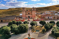
Tisco's church and main plaza
Peru location map.svg
Red pog.svg
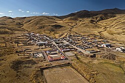
Tisco
Location of Tisco in the Caylloma province
Coordinates: 15°20′51″S71°26′46″W / 15.3476°S 71.4461°W / -15.3476; -71.4461
Country Flag of Peru.svg  Peru
Region Arequipa
Province Caylloma
Capital Tisco
Government
   Mayor Primitivo Sebastian Huaracha Ancca
Area
  Total1,445.02 km2 (557.93 sq mi)
Elevation
4,188 m (13,740 ft)
Population
  Total2,249
  Density1.6/km2 (4.0/sq mi)
Time zone UTC-5 (PET)
UBIGEO 040517

Tisco District is one of twenty districts of the province Caylloma in Peru. [1]

Contents

Geography

Some of the highest mountains of the district are listed below: [2]

Ethnic groups

The people in the district are mainly indigenous citizens of Quechua descent. Quechua is the language which the majority of the population (86.76%) learnt to speak in childhood, 13.06% of the residents started speaking using the Spanish language (2007 Peru Census). [3]

See also

Related Research Articles

Arequipa Province Province in Arequipa, Peru

Arequipa is a province in the Arequipa Region, Peru. Its capital, Arequipa, is Peru's third most populous province of Peru. It borders the provinces of Islay, Camaná, Caylloma, and the Cusco and Puno regions. According to INEI in the year 2014 it has a population of 958.351 people.

Lampa Province Province in Puno, Peru

Lampa province is a province of the Puno Region in Peru. Its population is about 40,856. The capital is Lampa.

General Sánchez Cerro Province Province in Moquegua, Peru

The General Sánchez Cerro Province is the smallest of three provinces in the Moquegua Region of Peru. The capital of the province is Omate. The province was named after the former Peruvian army officer and president Luis Miguel Sánchez Cerro.

La Mar Province Province in Ayacucho, Peru

La Mar Province is a province in the north-east corner of the Ayacucho Region, Peru. It was created on March 30, 1861.

Espinar Province Province in Cusco, Peru

Espinar Province is one of thirteen provinces in the Cusco Region in the southern highlands of Peru.

Castilla Province Province in Arequipa, Peru

Castilla Province is one of eight provinces in the Arequipa Region of Peru. It was named after Ramón Castilla.

Caylloma Province Province in Arequipa, Peru

Caylloma Province is the largest of eight provinces in the Arequipa Region of Peru.

Chapimarca District is one of the seventeen districts of the Aymaraes Province in Peru.

Chojata District District in Moquegua, Peru

Chojata District is one of eleven districts of the General Sánchez Cerro Province in Peru.

San Anton District is one of fifteen districts of the Azángaro Province in Peru.

Ollachea District is one of ten districts of the province Carabaya in Peru.

Ocuviri District is one of ten districts of the province Lampa in Peru.

Marangani District District in Cusco, Peru

Marangani District is one of eight districts of the province Canchis in Peru.

Colquemarca is one of eight districts of the Chumbivilcas Province in Peru.

Santo Tomás District is one of eight districts of the province Chumbivilcas in Peru.

Condoroma District is one of eight districts of the province Espinar in Peru.

Pallpata District is one of eight districts of the Espinar Province in Peru.

Choco District District in Arequipa, Peru

Choco District is one of fourteen districts of the province Castilla in Peru.

Caylloma District is one of twenty districts of the province Caylloma in Peru.

Tapay District District in Arequipa, Peru

Tapay District is one of twenty districts of Caylloma Province in Peru.

References

  1. (in Spanish) Instituto Nacional de Estadística e Informática. Banco de Información Distrital Archived 2008-04-10 at the Wayback Machine . Retrieved April 11, 2008.
  2. escale.minedu.gob.pe - UGEL maps of the Caylloma Province 1 and 2 (Arequipa Region)
  3. inei.gob.pe Archived 2013-01-27 at the Wayback Machine INEI, Peru, Censos Nacionales 2007, Frequencias: Preguntas de Población: Idioma o lengua con el que aprendió hablar (in Spanish)

Coordinates: 15°20′51″S71°26′46″W / 15.3476°S 71.4461°W / -15.3476; -71.4461