Lari | |
|---|---|
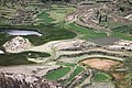
 Colca River with the village of Lari in the background | |
 Interactive map of Lari | |
| Country | |
| Region | Arequipa |
| Province | Caylloma |
| Capital | Lari |
| Government | |
| • Mayor | Abel Abdon Llallacachi Silloca |
| Area | |
• Total | 384.02 km2 (148.27 sq mi) |
| Elevation | 3,330 m (10,930 ft) |
| Population | |
• Total | 1,370 |
| • Density | 3.57/km2 (9.24/sq mi) |
| Time zone | UTC-5 (PET) |
| UBIGEO | 040510 |
Lari District is one of twenty districts of the province Caylloma in Peru. [1]