San Juan de Tarucani District

Last updated
San Juan de Tarucani
Tarujani
Laguna Salinas, Peru.jpg
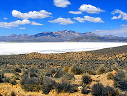
Lake Salinas, Tarucani District
San Juan de Tarucani District
Country Flag of Peru.svg  Peru
Region Arequipa
Province Arequipa
FoundedJune 15, 1962
Capital Tarucani
Government
   Mayor Floro Choque Vilca
Area
  Total
2,264.59 km2 (874.36 sq mi)
Elevation
4,210 m (13,810 ft)
Population
  Total
2,296
  Density1.0/km2 (2.6/sq mi)
Time zone UTC-5 (PET)
UBIGEO 040119

San Juan de Tarucani District (Aymara Tarujani, taruja deer, [1] -ni a suffix, "the one with deer") is one of 29 districts of the province Arequipa in Peru. [2]

Contents

Geography

The highest elevation of the district is the Misti volcano at 5,822 m (19,101 ft). Other mountains are listed below: [3]

See also

References

  1. Radio San Gabriel, "Instituto Radiofonico de Promoción Aymara" (IRPA) 1993, Republicado por Instituto de las Lenguas y Literaturas Andinas-Amazónicas (ILLLA-A) 2011, Transcripción del Vocabulario de la Lengua Aymara, P. Ludovico Bertonio 1612 (Spanish-Aymara-Aymara-Spanish dictionary)
  2. (in Spanish) Instituto Nacional de Estadística e Informática. Banco de Información Distrital Archived 2008-04-23 at the Wayback Machine . Retrieved April 11, 2008.
  3. escale.minedu.gob.pe - UGEL map of the General Sánchez Cerro (Moquegua Region)

16°10′59″S71°04′01″W / 16.18306°S 71.06694°W / -16.18306; -71.06694