Misti, also known as Putina or Guagua Putina is a stratovolcano of andesite, dacite and rhyolite located in southern Peru near the city of Arequipa. With its seasonally snow-capped, symmetrical cone, Misti stands at 5,822 metres (19,101 ft) above sea level and lies between mount Chachani and Pichu Pichu volcano. Its last eruption was in 1985, 198 years after its previous documented eruption.

Arequipa is a department in southwestern Peru. It is the sixth largest department in Peru, after Puno, Cuzco, Madre de Dios, Ucayali, and Loreto, its sixth most populous department, and its eleventh least densely populated department. It is bordered by the departments of Ica, Ayacucho, Apurímac and Cusco in the north, the Department of Puno in the east, the Department of Moquegua in the south, and the Pacific Ocean in the west. Its capital, also called Arequipa, is Peru's second-largest city.

Puno is a department in southeastern Peru. It is the fifth largest department in Peru, after Cuzco, Madre de Dios, Ucayali, and Loreto It is bordered by Bolivia on the east, the departments of Madre de Dios on the north, Cusco and Arequipa on the west, Moquegua on the southwest, and Tacna on the south. Its capital is the city of Puno, which is located on Lake Titicaca in the geographical region known as the Altiplano or high sierra.
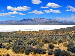
Salinas y Aguada Blanca National Reserve is a protected area located in the regions of Arequipa and Moquegua; Peru. The main purpose of this area is to protect the local flora, fauna and landscape formations.

San Juan de Tarucani District is one of 29 districts of the province Arequipa in Peru.
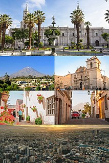
Arequipa is a city located in the province and the eponymous department of Peru. It is the seat of the Constitutional Court of Peru and often dubbed the "legal capital of Peru." It is the second most populated city in Peru, after Lima, with an urban population of 1,008,290 inhabitants according to the 2017 national census.

Hualca Hualca is an extinct volcano in Arequipa Region in the Andes of Peru. It has a height of 6,025 metres.

Pichu Pichu or Picchu Picchu is an inactive eroded volcano in the Andes of Peru. It is located in the Arequipa Region, Arequipa Province, on the border of Pocsi and Tarucani districts. Pichu Pichu reaches a height of 5,664 metres (18,583 ft) and is part of Salinas and Aguada Blanca National Reserve.

Andean Baroque is an artistic movement that appeared in colonial Peru between 1680 and 1780. It is located geographically between Arequipa and Lake Titicaca in what is now Peru and Bolivia, where rules over the highlands and spreads over the entire altiplano. From the Portuguese word barrueco meaning impure, mottled, flamboyant, daring, the most striking example of Andean Baroque art is in religious architecture, where criollo and indigenous craftsmen together gave it a unique character, as happened in the New Spanish Baroque.
Wila Quta or Wilaquta may refer to:
Janq'u Quta may refer to:
Urququcha, Urqu Qucha, Urqunqucha, or Orconcocha may refer to any of the following lakes:

Qillqata is a mountain in the Andes of Peru, about 5,200 metres (17,060 ft) high. It is located southeast of Lake Salinas in the Arequipa Region, Arequipa Province, Tarucani District, and in the Moquegua Region, General Sánchez Cerro Province, Coalaque District. Some of the highest mountains near Qillqata are Wilani in the northeast, Q'uwa Laki in the southeast and Pachakutiq.
Pachakutiq is a 5,173-metre-high (16,972 ft) mountain in the Andes of Peru. It is located southeast of Lake Salinas in the Arequipa Region, Arequipa Province, Tarucani District, and in the Moquegua Region, General Sánchez Cerro Province, Coalaque District. Pachakutiq lies northwest of Q'uwa Laki and Qillqata.
Tacune is a mountain in the Andes of Peru, about 5,500 metres (18,045 ft) high. It is situated south of Lake Salinas and east of the mountain Pichu Pichu. Tacune is located in the Arequipa Region, Arequipa Province, Tarucani District, and in the Moquegua Region, General Sánchez Cerro Province, Puquina District.
Puka Saya is a mountain in the Arequipa Region in the Andes of Peru, about 5,000 metres (16,404 ft) high. It is situated in the Arequipa Province, Tarucani District, north of Lake Salinas. Puka Saya lies southwest of Kunturi.
Q'illuqucha may refer to:

Chachani is a volcanic complex in southern Peru, 22 kilometres (14 mi) northwest of the city of Arequipa. Part of the Central Volcanic Zone of the Andes, it is 6,057 metres (19,872 ft) above sea level. It consists of several lava domes and individual volcanoes such as Nocarane, along with lava shields such as the Airport Domes. Underneath Chachani lies a caldera.