Choco | |
|---|---|
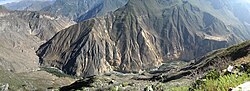 Apachita mountain and Qullqa River on the border of the districts of Choco (on the left) and Tapay | |
 | |
| Country | |
| Region | Arequipa |
| Province | Castilla |
| Founded | January 2, 1857 |
| Capital | Choco |
| Government | |
| • Mayor | Trifonio Lucas Aragon Lupaca |
| Area | |
• Total | 904.33 km2 (349.16 sq mi) |
| Elevation | 2,473 m (8,114 ft) |
| Population | |
• Total | 1,235 |
| • Density | 1.4/km2 (3.5/sq mi) |
| Time zone | UTC-5 (PET) |
| UBIGEO | 040406 |
Choco District is one of fourteen districts of the province Castilla in Peru. [1]