
The Cordillera Central is part of the Andes in Peru. It extends in a northerly direction approximately between 11º 39’ and 12º 37’S and 75º 30’ and 76º 20’W for about 60 km to 100 km. It contains the Paryaqaqa (P), Yauyos (Y) and Pichqa Waqra (PW) mountain ranges. It is located in the Junín Region and in the Lima Region.

Puca Mauras is a volcano in the Andes of Peru, about 4,262 metres (13,983 ft) high. It is situated at the "Valley of the Volcanoes" in the Arequipa Region, Castilla Province, on the border of the districts of Andagua and Chilcaymarca. Puca Mauras lies in the western extensions of the Chila mountain range, northeast of the Ticsho and Yanamauras volcanoes.
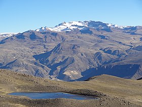
Ticlla is a 5,072-metre-high (16,640 ft) mountain in the Chila mountain range in the Andes of Peru. It is located in the Arequipa Region, Caylloma Province, on the border of the districts of Caylloma and Tuti. Ticlla lies southwest of Jatunchungara and Chungara.
Chila is a mountain in the Andes of Peru, about 5,111.2 metres (16,769 ft) high. It lies in the Arequipa Region, Castilla Province, Choco District, and in the Caylloma Province, Caylloma District. Chila is situated southeast of the lake Llocococha.
Pillune is a mountain in the Chila mountain range in the Andes of Peru, about 5,000 m (16,000 ft) high. It is situated in the Arequipa Region, Castilla Province, Chachas District. Pillune lies southeast of a lake named Machucocha.
Chungara is a mountain in the Chila mountain range in the Andes of Peru, about 5,000 m (16,404 ft) high. It is located in the Arequipa Region, Caylloma Province, on the border of the districts of Caylloma and Tuti. It lies south of Jatunchungara and Mesa Chungara and northeast of Ticlla.
Chinchón is a mountain in the western part of the Chila mountain range in the Andes of Peru, about 5,400 metres (17,717 ft) high. It lies in the Arequipa Region, Castilla Province, Chachas District. Chinchón is situated southwest of Huayta and southeast of Aceruta.

Apacheta is a 5,328-metre-high (17,480 ft) mountain in the western part of the Chila mountain range in the Andes of Peru. It lies in the Arequipa Region, Castilla Province, Chachas District. It is situated southwest of Chila, northeast of Chila Pillune and southeast of Yuaytacondorsenja.
Chila Pillune is a mountain in the western part of the Chila mountain range in the Andes of Peru, about 5,328 m (17,480 ft) high. It lies in the Arequipa Region, Castilla Province, Chachas District. Chila Pillune is situated west of Chila, the highest mountain of the range, northeast of Ticlla and south of Apacheta.
Ticlla is a 5,303-metre-high (17,398 ft) mountain in the Chila mountain range in the Andes of Peru. It is located in the Arequipa Region, Castilla Province, Chachas District. Ticlla lies southwest of Chila and Chila Pillune at a valley named Puncuhuaico. Its intermittent stream flows to Chachas Lake.
Quiscapampa or Quiscapanca is a mountain in the Chila mountain in the Andes of Peru, about 5,400 m (17,717 ft) high. It is located in the Arequipa Region, Castilla Province, Choco District. Quiscapampa lies northwest of Ojeccasa and southwest of Airicoto.
Airicoto is a mountain in the Chila mountain in the Andes of Peru, about 5,400 m (17,700 ft) high. It is located in the Arequipa Region, Castilla Province, Choco District. It lies northeast of Quiscapampa and east of Yuraccacsa.
Huayta is a mountain in the Chila mountain range in the Andes of Peru, about 5,400 m (17,717 ft) high. It is located in the Arequipa Region, Castilla Province, Chachas District. Huayta lies south of Huanca and Sullucullahua, northeast of Chinchón and southeast of Aceruta.
Yuaytacondorsenja is a 5,345-metre-high (17,536 ft) mountain in the Chila mountain range in the Andes of Peru. It is located in the Arequipa Region, Castilla Province, Chachas District. Yuaytacondorsenja lies northwest of Chila and Chila Pillune. It is situated at the end of a valley named Puncuhuaico. Its stream flows to Chachas Lake.
Ticlla is a mountain in the Chila mountain range in the Andes of Peru, about 4,800 m (15,700 ft) high. It is located in the Arequipa Region, Castilla Province, Chachas District. Tiklla lies at the Cacamayo, east of Huayllayoc and southeast of Huamanripayoq.
Huamanripayoc is a mountain in the Chila mountain range in the Andes of Peru, about 5,000 m (16,000 ft) high. It is located in the Arequipa Region, Castilla Province, Chachas District. Huamanripayoc lies at the Cacamayo, northwest of Ticlla and northeast of Huayllayoc.
Samacasa is a mountain in the Chila mountain range in the Andes of Peru, about 5,200 m (17,100 ft) high. It is located in the Arequipa Region, Castilla Province, Chachas District. Samacasa lies north of Airicoto.
Icma is a mountain in the west of the Chila mountain range in the Andes of Peru, about 4,800 m (15,700 ft) high. It is located in the Arequipa Region, Castilla Province, Chachas District. Ikma lies southwest of Casiri at a lake named Cochapunco.
Puca Mauras is a 4,955-metre-high (16,257 ft) volcano in the Andes of Peru. It is situated in the Arequipa Region, Castilla Province, Chachas District. Puca Mauras lies in the western extensions of the Chila mountain range, west of a lake named Cochapunco.


