
Machu Picchu is a 15th-century Inca citadel, located in the Eastern Cordillera of southern Peru, on a mountain ridge 2,430 metres (7,970 ft) above sea level. It is located in the Cusco Region, Urubamba Province, Machupicchu District in Peru, above the Sacred Valley, which is 80 kilometres (50 mi) northwest of Cuzco and through which the Urubamba River flows, which cuts through the Cordillera and originates a canyon with a tropical mountain climate.

Arequipa is a department in southwestern Peru. It is bordered by the departments of Ica, Ayacucho, Apurímac and Cusco in the north, the Department of Puno in the east, the Department of Moquegua in the south, and the Pacific Ocean in the west. Its capital, also called Arequipa, is Peru's second-largest city.
Manga Sewa was a Yalunka paramount chief in British Sierra Leone who blew up a magazine and much of Falaba, the capital of Solimana, killing himself, his family and other leaders, rather than let it fall to Samori Toure's army.
Solimana was a minor West African state of the nineteenth century with a capital at the fortress town of Falaba. Situated on rich slave-trading routes in what is now Sierra Leone, Solimana was visited in 1822 by Alexander Gordon Laing and in 1869 by William Winwood Reade, making it nominally British.

La Unión is a province of the Arequipa Region in Peru. Its seat is Cotahuasi.

Ampato is a dormant 6,288-metre (20,630 ft) stratovolcano in the Andes of southern Peru. It lies about 70–75 kilometres (43–47 mi) northwest of Arequipa and is part of a north-south chain that includes the volcanoes Hualca Hualca and Sabancaya, the last of which has been active in historical time.

Cotahuasi Canyon near the city of Arequipa in Peru is one of the deepest canyons in the world. The canyon is an impressive chasm that the river has eroded between two enormous mountain massifs: the Coropuna and the Solimana. One extends from spurs of the snow-covered Solimana to the confluence with the Ocoña river. Cotahuasi Canyon was cut by the Rio Cotahuasi, a tributary of the Rio Ocoña, to a depth of approximately 3354 meters - over twice the depth of the Grand Canyon.

Giovanni Battista Pastene (1507–1580) was a Genoese maritime explorer who, while in the service of the Spanish crown, explored the coasts of Panama, Colombia, Ecuador, Peru and Chile as far south as to the archipelago of Chiloé.
Chichas District is one of eight districts of the province Condesuyos in Peru.

Hualca Hualca is an extinct volcano in Arequipa Region in the Andes of Peru. It has a height of 6,025 metres.
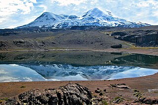
Solimana is a volcanic massif in the Andes of Peru, South America, that is approximately 6,093 metres (19,990 ft) high. It is considered an extinct volcano that is part of the Central Volcanic Zone, one of the volcanic belts of the Andes. It features a caldera as well as traces of a sector collapse and subsequent erosion. The volcano is glaciated.
Mawk'allaqta, also Mawk'a Llaqta is an archaeological site in Peru. It is located in the Arequipa Region, La Unión Province, Puyca District, located about 2 kilometers from Puyca.
Coropuna is a dormant volcano in the southern Peruvian Andes and belonging to the Central Volcanic Zone; its summit reaches an altitude of 6,377 metres above sea level. The volcano, located 155 kilometres from Arequipa, is mostly made of lava flows on a basement formed by Miocene ignimbrites. Coropuna has been active for at least five million years, with the bulk of the current cone having formed during the Pliocene–Pleistocene.

Firura is an extinct volcano of the Central Andean Volcanic Belt, located in the Arequipa Region of southern Peru. Together with Sara Sara, Solimana and Coropuna it forms one of the Central Andean volcanoes. It is in the Andes, north of the Pucuncho Basin.

Tutupaca is a volcano in the region of Tacna in Peru. It is part of the Peruvian segment of the Central Volcanic Zone, one of several volcanic belts in the Andes. Tutupaca consists of three overlapping volcanoes formed by lava flows and lava domes made out of andesite and dacite, which grew on top of older volcanic rocks. The highest of these is usually reported to be 5,815 metres (19,078 ft) high and was glaciated in the past.

Ticsani is a volcano in Peru. It consists of two volcanoes that form a complex: "old Ticsani", which is a compound volcano that underwent a large collapse in the past and shed 15–30 cubic kilometres (3.6–7.2 cu mi) of mass down the Rio Tambo valley; the other is a complex of three lava domes which were emplaced during the Holocene. The last eruption occurred after the 1600 eruption of neighbouring Huaynaputina.


