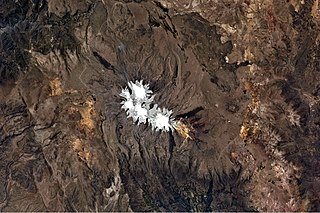
Waqrawiri or Waxra Wiri is a mountain in the Wansu mountain range in the Andes of Peru, about 5,425 metres (17,799 ft) high. It is situated in the Arequipa Region, Castilla Province, Orcopampa District. Waqrawiri lies northwest of the lake Machuqucha and south of the river Millumayu.

Yurac Apacheta is a mountain in the Andes of Peru, about 4,200 metres (13,780 ft) high. It is situated in the Arequipa Region, Arequipa Province, Yura District, and in the Caylloma Province, Huanca District.

Ccella Ccella is a mountain in the Chila in the Andes of Peru, about 5,049 metres (16,565 ft) high. It is situated in the Arequipa Region, Castilla Province, Choco District, and in the Caylloma Province, on the border of the districts of Caylloma and Tapay.

Choquepirhua is a mountain in the Chila mountain range in the Andes of Peru, about 5,400 metres (17,717 ft) high. It lies in the Arequipa Region, Castilla Province, on the border of the districts of Chachas and Choco. Choquepirhua is situated south of Chila.

Qullpa is a mountain in the Andes of Peru, about 5,226.4 metres (17,147 ft) high. It is situated in the Arequipa Region, Castilla Province, on the border of the districts Ayo and Uñón. Qullpa lies south of the mountain Yanqha.

Yanqha is a mountain in the Andes of Peru, about 5,200 metres (17,060 ft) high. It is situated in the Arequipa Region, Castilla Province, on the border of the districts Ayo and Uñón. Yanqha lies south of the mountains Yanawara and Yana Urqu and north of the mountain Qullpa.

Chuqllu Chuqllu or Chhuxllu Chhuxllu is a mountain in the Wansu mountain range in the Andes of Peru, about 5,000 metres (16,404 ft) high. It is situated in the Arequipa Region, Castilla Province, Orcopampa District.

Aceruta is a mountain in the Andes of Peru, about 5,400 metres (17,717 ft) high. It is situated in the Arequipa Region, Castilla Province, Chachas District. It lies north-west of the mountain Huayta and north-east of the mountain Huañacagua.

Qullpa is a mountain in the Wansu mountain range in the Andes of Peru, about 5,100 metres (16,732 ft) high. It is situated in the Arequipa Region, La Unión Province, Puyca District, and in the Cusco Region, Chumbivilcas Province, Santo Tomás District. It lies northwest of the mountains Qullpa K'uchu and Minasniyuq.

P'isqi P'isqi is a mountain in the Andes of Peru, about 4,600 metres (15,092 ft) high. It lies in the Arequipa Region, Castilla Province, Andagua District. P'isqi P'isqi is situated west of Wakapallqa and Llallawi.

Pukara is a mountain in the Andes of Peru, about 5,000 metres (16,404 ft) high. It is located in the Arequipa Region, Arequipa Province, Tarucani District. Pukara lies north of Wilani and northeast of Qillqata.

Yana Yana is a 5,321-metre-high (17,457 ft) mountain in the Wansu mountain range in the Andes of Peru. It is situated in the Arequipa Region, Condesuyos Province, Cayarani District, and in the La Unión Province, Puyca District. Yana Yana lies northeast of Janq'u Q'awa and southeast of Kunturi.

Pukara is a mountain in the Wansu mountain range in the Andes of Peru, about 5,000 metres (16,404 ft) high. It is situated in the Arequipa Region, Condesuyos Province, Cayarani District. Pukara lies southeast of Yana Yana.

Kimsa Chata is a group of three mountains in the Wansu mountain range in the Andes of Peru. Its central peak reaches 5,091 metres (16,703 ft) above sea level. It is situated in the Arequipa Region, La Unión Province, Huaynacotas District. Kimsa Chata lies at the Yana Wanaku valley southeast of Hatun Pata.

Sullu Marka is a mountain in the Wansu mountain range in the Andes of Peru, about 5,000 metres (16,404 ft) high. It is situated in the Arequipa Region, La Unión Province, Huaynacotas District. It lies southwest of Hatun Sisiwa. Sullu Marka is also the name of the mountain just west of Hatun Sisiwa.

Yuraq Apachita is a mountain in the Wansu mountain range in the Andes of Peru, about 5,000 metres (16,404 ft) high. It is situated in the Arequipa Region, La Unión Province, Huaynacotas District. Yuraq Apachita lies southeast of Puka Willka.

Cairahuiri is a mountain in the Chila mountain range in the Andes of Peru, about 5,000 metres (16,404 ft) high. It is situated in the Arequipa Region, Caylloma Province, Tapay District. Cairahuiri lies southwest of Minasnioc, northwest of Surihuiri and Minaspata, northeast of Huaillaccocha and west of Huallatane. It stretches along the Cairahuiri River whose waters flow to the Molloco River in the west, a right affluent of the Colca River.

Huanca is a 5,200-metre-high (17,060 ft) mountain in the Chila mountain range in the Andes of Peru. It is located in the Arequipa Region, Castilla Province, Chachas District. Huanca lies southwest of Huayllatarpuna and Condorcacha and northeast of Chinchón and Aceruta.

Samacasa is a mountain in the Chila mountain range in the Andes of Peru, about 5,200 m (17,100 ft) high. It is located in the Arequipa Region, Castilla Province, Chachas District. Samacasa lies north of Airicoto.

Tanka is a 4,783-metre-high (15,692 ft) mountain in the Andes of Peru. It is situated in the Arequipa Region, Condesuyos Province, Cayarani District, in the southern extensions of the Wansu mountain range. Tanka lies at the Puma Ranra valley, south of Allqa Q'awa.


