Huaytapallana

Last updated
Huaytapallana
Panoramic View of Huaytapallana.jpg
Highest point
Elevation 5,557 m (18,232 ft)
Listing List of mountains in the Andes
Coordinates 11°54′29″S75°03′15″W / 11.90806°S 75.05417°W / -11.90806; -75.05417 Coordinates: 11°54′29″S75°03′15″W / 11.90806°S 75.05417°W / -11.90806; -75.05417
Geography
Peru physical map.svg
Red triangle with thick white border.svg
Huaytapallana
Peru
Location Peru, Junín Region, Huancayo Province, Huancayo District, Pariahuanca District
Parent range Andes, Huaytapallana
Glacier Huaytapallana Glacier Huaytapallana-4.jpg
Glacier Huaytapallana

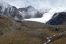
Huaytapallana (possibly from in the Quechua spelling Waytapallana; wayta wild flower, a little bunch of flowers, pallay to collect, pallana an instrument to collect fruit / collectable, Waytapallana "a place where you collect wild flowers", [1] [2] ) or Lasuntay is the highest peak in the Huaytapallana mountain range in the Andes of Peru. [3] Its summit reaches about 5,557 m (18,232 ft) above sea level. The mountain is situated in the Junín Region, Huancayo Province, in the districts of Huancayo and Pariahuanca. [4]

Related Research Articles

Department of Junín Departments of Peru

Junín is a department and region in the central highlands and westernmost Peruvian Amazon. Its capital is Huancayo.

Huaytapallana mountain range

The Huaytapallana mountain range lies in the Junín Region in the Andes of Peru. It extends between 11°47' and 11°56'S and 75°00' and 75°05'W for about 17 km. The surface area of the zone is 378'40 km². The range is located in the provinces of Concepción and Huancayo.

Marairazo

Marairazo is a mountain in the northern sector of the Huaytapallana mountain range in the Andes of Peru, about 4,943 metres (16,217 ft) high. It is situated in the Junín Region, Concepción Province, Comas District, and in the Jauja Province, in the districts of Apata and Monobamba.

Tillu

T'illu is a mountain in the Andes of Peru, about 5,050 metres (16,568 ft) high. It is situated in the northern part of the main sector of the Waytapallana mountain range. It lies in the Junín Region, Concepción Province, Comas District.

Carhuachuco

Carhuachuco is a mountain in the Pariacaca mountain range in the Andes of Peru, about 5,507 metres (18,068 ft) high. It is situated in the Junín Region, Yauli Province, in the districts Suitucancha and Yauli. Carhuachuco lies south of the mountain Putka and south-west of the lake Putkaqucha.

Putkaqucha (Concepción)

Putkaqucha is a mountain in Peru, about 4,800 m (15,748 ft) high, at a lake of that name. The mountain and the lake are located in the Junín Region, Concepción Province, Andamarca District, northeast of the Waytapallana mountain range. The peak of Putkaqucha is south of Utkhu Warqu.

Putkaqucha

Putkaqucha is a 5,236-metre-high (17,178 ft) mountain in the Waytapallana mountain range in Peru. It is located in the Junín Region, Concepción Province, Comas District, and in the Huancayo Province, on the border of the districts of El Tambo and Quilcas. Putkaqucha lies southwest of Puywan and northwest of Waytapallana and Ch'uspi.

Lake Ancapuachanan

Lake Ancapuachanan is a small lake in the Huaytapallana mountain range in Peru. It is located in the Junín Region, Huancayo Province, El Tambo District. Lake Ancapuachanan is situated north of the lake named Chuspicocha and southwest of Mount Chuspi.

Tikapallana

T'ikapallana is a mountain in the Andes of Peru. Its summit reaches about 4,304.1 m (14,121 ft) above sea level. T'ikapallana is situated in the Cusco Region, Chumbivilcas Province, Chamaca District.

Puywan

Puywan is a mountain in the northern sector of the Waytapallana mountain range in the Andes of Peru, about 5,100 metres (16,732 ft) high. It is situated in the Junín Region, Huancayo Province, Pariahuanca District, and in the Concepción Province, Comas District. Puywan lies southeast of T'illu and northeast of Ch'uspi.

Waytapallana (Aychana)

Waytapallana is a mountain in the Andes of Peru, about 4,800 m (15,748 ft) high. It is situated in the Junín Region, Huancayo Province, Pariahuanca District. Waytapallana lies on the left bank of the Lampa River, east of the Waytapallana mountain range. The village of Aychana lies at its feet.

Yawray

Yawray is a 5,112-metre-high (16,772 ft) mountain in the Andes of Peru. It is located in the Huancavelica Region, Huancavelica Province, Acobambilla District, and in the Junín Region, Huancayo Province, Chongos Alto District. Yawray lies west of Puka and Warmi Mach'ay. Yawray is situated northwest of Aqchiqucha and northeast of Warmiqucha which belong to the largest lakes of Peru.

Waqra Willka

Waqra Willka is a 5,066-metre-high (16,621 ft) mountain in the Andes of Peru. It is located in the Junín Region, Huancayo Province, Chongos Alto District. Waqra Willka lies east of Wira Challwa. A couple of small lakes named Yuraqqucha, Anqasqucha, Challwaqucha and Antaqucha are situated at the feet of the mountain.

Yana Wachuku

Yana Wachuku is a 5,012-metre-high (16,444 ft) mountain in the Andes of Peru. It is located in the Junín Region, Yauli Province, on the border of the districts of Carhuacayan and Marcapomacocha. It lies southeast of Allqay.

Alcay (Junin)

Alcay or Alcoy is a 5,359-metre-high (17,582 ft) mountain in the Andes of Peru. It is located in the Junín Region, Yauli Province, Carhuacayan District and in the Lima Region, Huaral Province, Atavillos Alto District. It lies southwest of Yanque.

Kawituyuq

Kawituyuq is a 4,803-metre-high (15,758 ft) mountain in the Andes of Peru. It is located in the Junín Region, Huancayo Province, Huancayo District. Kawituyuq lies south of the Waytapallana mountain range, southwest of Yana Uqsha.

Qalla Qhata

Qalla Qhata is a mountain in the Waytapallana mountain range in Peru, about 5,200 m (17,100 ft) high. It is located in the Junín Region, Huancayo Province, Huancayo District, west of Waytapallana.

Shawaq

Shawaq is a mountain in the Andes of Peru, about 5,100 metres (16,732 ft) high. It is located in the Junín Region, Yauli Province, Morococha District, north of a lake named Waqraqucha.

Lasu Tumi

Lasu Tumi is a mountain in Peru, about 5,200 m (17,100 ft) high. It is located in the Junín Region, Huancayo Province, Pariahuanca District. It lies northeast of a mountain named Ututuyuq.

Waqutuyuq (Junín)

Waqutuyuq is a mountain in the Andes of Peru which reaches a height of approximately 4,200 metres (13,780 ft). It is located in the Junín Region, Jauja Province, Pomacancha District.

References

  1. Teofilo Laime Ajacopa, Diccionario Bilingüe Iskay simipi yuyayk'ancha, La Paz, 2007 (Quechua-Spanish dictionary)
  2. Diccionario Quechua - Español - Quechua, Academía Mayor de la Lengua Quechua, Gobierno Regional Cusco, Cusco 2005 (Quechua_Spanish dictionary)
  3. Evelio Echevarría, Cordillera Huaytapallana, Peru, in: The Alpine Journal, 2009, p. 161-167
  4. escale.minedu.gob.pe - UGEL map of the Huancayo Province (Junín Region)