Related Research Articles
Karnataka, is a state in the southwestern region of India. It was formed as Mysore State on 1 November 1956, with the passage of the States Reorganisation Act, and renamed Karnataka in 1973. The state was part of the Carnatic region in British terminology. Its capital and largest city is Bengaluru (Bangalore).

The Western Ghats, also known as the Sahyadri mountain range, is a mountain range that covers an area of 160,000 km2 (62,000 sq mi) in a stretch of 1,600 km (990 mi) parallel to the western coast of the Indian peninsula, traversing the states of Gujarat, Maharashtra, Goa, Karnataka, Kerala and Tamil Nadu. It is a UNESCO World Heritage Site and one of the 36 biodiversity hotspots in the world. It is sometimes called the Great Escarpment of India. It contains a very large proportion of the country's flora and fauna, many of which are endemic to this region. The Western Ghats are older than the Himalayas. They influence Indian monsoon weather patterns by intercepting the rain-laden monsoon winds that sweep in from the south-west during late summer. The range runs north to south along the western edge of the Deccan Plateau and separates the plateau from a narrow coastal plain called the Western Coastal Plains along the Arabian Sea. A total of 39 areas in the Western Ghats, including national parks, wildlife sanctuaries and reserve forests, were designated as world heritage sites in 2012 – twenty of them in Kerala, ten in Karnataka, six in Tamil Nadu and four in Maharashtra.
Wayanad is a district in the north-east of the Indian state of Kerala, with administrative headquarters at the municipality of Kalpetta. It is the only plateau in Kerala. The Wayanad Plateau forms a continuation of the Mysore Plateau, the southern portion of Deccan Plateau which links the Western Ghats with the Eastern Ghats. It is set high in the Western Ghats with altitudes ranging from 700 to 2,100 meters. Vellari Mala, a 2,240 m (7,349 ft) high peak situated on the trijunction of Wayanad, Malappuram, and Kozhikode districts, is the highest point in Wayanad district. The district was formed on 1 November 1980 as the 12th district in Kerala, by carving out areas from Kozhikode and Kannur districts. An area of 885.92 km2 in the district is forested. Wayanad has three municipal towns—Kalpetta, Mananthavady and Sulthan Bathery. There are many indigenous tribes in this area. The Kabini River, a tributary of Kaveri River, originates at Wayanad. Wayanad district, along with the Chaliyar valley in the neighbouring Nilambur in Malappuram district, is known for natural gold fields, which are also seen in other parts of the Nilgiri Biosphere Reserve. Chaliyar river, which is the fourth longest river of Kerala, originates on the Wayanad plateau. The historically important Edakkal Caves are located in Wayanad district.

The large Deccan Plateau in southern India is located between the Western Ghats and the Eastern Ghats, and is loosely defined as the peninsular region between these ranges that is south of the Narmada River. To the north, it is bounded by the Satpura and Vindhya Ranges.

Dakshina Kannada district is located in the state of Karnataka in India, with its headquarters in the coastal city of Mangalore. It is part of the larger Tulu Nadu region. The district covers an area nestled in between the Western Ghats to its east and the Arabian Sea to its west. Dakshina Kannada receives abundant rainfall during the Indian monsoon. It is bordered by Udupi district to the north, Chikmagalur district to the northeast, Hassan district to the east, Kodagu to the southeast and Kasaragod district of Kerala to the south. According to the 2011 census of India, Dakshina Kannada district had a population of 2,083,625. It is the only district in Karnataka state to have all modes of transport like road, rail, water and air due to the presence of a major hub, Mangalore. This financial district is also known as the Cradle of Indian banking.

Kodachadri is a mountain peak with dense forests in the Western Ghats in South India, 78 km from Shimoga. Kodachadri is the highest peak in Shivamogga district. It is declared as natural heritage site by the Karnataka Government. and it is 13th highest peak of Karnataka.

Kongu Nadu, also known as Kongu Mandalam, is a geographical region comprising the western part of the Indian state of Tamil Nadu and parts of southeastern Karnataka and eastern Kerala. The region covers an area of roughly 60,895 km2 (23,512 sq mi) with a population of over 27.4 million.

Humcha / Hombuja is a small town near Ripponpet, Hosanagara taluk in Shimoga district in the Indian state of Karnataka. Humbaja Atishaya Jain Teerth Kshetra is famous for being home to an ancient temple of Goddess Padmavati, and to the Humbaj Matha (seminary/monastery), an important institution of the Jain community. This temple is considered to be very holy and is known for its cultural and historical heritage. Other notable highlights of the place are a lake that reputedly never dries up and a tree that likewise always remains green.

Chikmagalur, known officially as Chikkamagaluru, is a city and the headquarters of Chikmagalur district in the Indian state of Karnataka. Located on the foothills of the Mullayanagiri peak of the Western Ghats, the city attracts tourists from around the world for its pleasant and favourable hill station climate, tropical rainforest and coffee estates. The pristine Baba Budangiri lies to the north of Chikmagalur where it's believed Baba Budan first introduced coffee to India.

Hassan is one of the 31 districts of Karnataka, India. The district headquarter is Hassan. It was carved out from Mysore district in the year 1866, during the Commissioner's Rule of Mysore (1831-81).
Vokkaliga is a community of closely related castes, from the Indian states of Karnataka and Tamil Nadu.
The Mysore region is an unofficial region that is part of Karnataka state in southern India. It forms approximately the southern half of the non-coastal areas of that state. The area corresponds almost exactly to that of the erstwhile princely state of Mysore. Almost all of that principality, with the exception of a few areas that now lie in neighbouring states, is comprehended by this term.

Bayaluseeme or Bayalu Seeme is the area lying to the east of Malenadu, a region of Karnataka state in India. The area is largely open plain, with few hillocks. It includes the districts of Bangalore, Bagalkot, Bijapur, Chitradurga, Davanagere, Dharwad, Gadag, Hassan, Haveri, Mandya, Mysore, and Tumkur.

Nayakas of Keladi (1499–1763), also known as Nayakas of Bednore and Ikkeri Nayakas, were an Indian dynasty based in Keladi in present-day Shimoga district of Karnataka, India. They were an important ruling dynasty in post-medieval Karnataka. They initially ruled as a vassal of the famous Vijayanagar Empire. After the fall of the empire in 1565, they gained independence and ruled significant parts of Malnad region of the Western Ghats in present-day Karnataka, most areas in the coastal regions of Karnataka and the central plains along the Tungabhadra river. In 1763 AD, with their defeat to Hyder Ali, they were absorbed into the Kingdom of Mysore. They played an important part in the history of Karnataka, during a time of confusion and fragmentation that generally prevailed in South India after the fall of the Vijayanagar Empire. The Keladi rulers were of the Vokkaliga and Banajiga castes and were Veerashaivas by faith. The Haleri Kingdom that ruled over Coorg between 1600 A.D and 1834 A.D. was founded by a member of the Keladi family.
The Alupa dynasty was an ancient ruling dynasty of India. The kingdom they ruled was known as Alvakheda Arusasira and its territory spanned the coastal districts of the modern Indian state known as Karnataka. The Alupas in their prime were an independent dynasty, centuries after reigning due to the dominance of Kadambas from Banavasi, they became feudatory to them. Later they became the vassals of the Chalukyas, Rashtrakutas, Hoysalas with the change in political scenario of Southern India. Their influence over coastal Karnataka lasted for about 1200 years. There is evidence that the Alupas followed the law of matrilineal inheritance (Appekatt/Aliyasantana) since the Alupa king Soyideva was succeeded by his nephew Kulasekhara Bankideva. The legendary king who is credited with introducing matrilineality in Alva Kheda|Tulu Vishaya Kheda is named Bhuta Alupa Pandya The descendants of this dynasty still survive to this date and have spread in the karavali region and they are widely referred to as the Bunt. The Bunts follow Matrilineality instead of the common Patrilineality, and are said to be Nagavanshi Kshatriyas by their maternal origin. They can be identified with their surnames such as Shetty, Rai, Hegde, Alva, Chowta etc. Even though most Bunt are Hindus by faith now, The sizeable section of the community still follows Jainism and they are called Jain Bunt The last Alupa king to have ruled is Kulasekharadeva Alupendradeva whose inscription dated 1444 CE have been found in Mudabidri Jain Basadi.
Vira Someshwara (1234–1263) was a king of the Hoysala Empire. The preoccupation of Vira Narasimha II in the affairs of Tamil country resulted in neglect of northern territories and he had to face Seuna incursions south of the Tungabhadra river.

The Indian State of Karnataka is located between 11°30' North and 18°30' North latitudes and between 74° East and 78°30' East longitude.It is situated on a tableland where the Western Ghats and Eastern Ghats converge into the complex, in the western part of the Deccan Peninsular region of India. The State is bounded by Maharashtra and Goa States in the north and northwest; by the Lakshadweep Sea in the west; by Kerala in the south-west and Tamil Nadu in the south and south-east, Andhra Pradesh in the south-east and east and Telangana in the north-east. Karnataka extends to about 850 km (530 mi) from north to south and about 450 km (280 mi) from east to west.
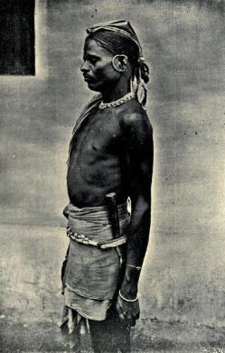
The Koraga are a tribal community or indigenous community found mainly in the Dakshina Kannada, Udupi districts of Karnataka and the Kasaragod district of Kerala, south India. These areas in Karnataka, are altogether often referred to as Tulunaad, which roughly corresponds to the boundaries of the erstwhile South Canara district. They are also found in small numbers in adjoining districts of Uttara Kannada, Shimoga and Kodagu. The Koraga are classified by the Government of India as a particularly vulnerable tribal group.
National Highway 169 is a National Highway in India. The national highway number 169 was previously part of old National highway 13 connecting Mangaluru in the state of Karnataka with Solapur in the state of Maharashtra. After rationalisation of highway numbers by Government of India published on 5 March 2010. This number has been assigned to national highway starting from Mangalooru to Shivamogga (Shimoga) going via Gurupura, Kaikamba, Yedapadavu, Moodabidri, Karkala, Bajagoli (Bajegoli), SK border, Kerekatte, Sringeri, Koppa and Thirthahalli. This road provides connectivity between Karavali (Coastal) region through Malenadu region of Karnataka state in India. This road is narrow at some stretches when passing through Kudremukha National Park forest area. The National Highway 169A joins this highway at Thirthahalli.

Santara or Bhairarasa was a medieval ruling dynasty of Karnataka, India. The area covered by their kingdom included territories in the Malenadu region as well as the coastal districts of Karnataka. Their kingdom had two capitals. Karkala in the coastal plains and Kalasa in the Western ghats. Hence the territory they ruled was also known as the Kalasa-Karkala kingdom. The Santaras were Jains and had matrimonial relations with the Saivite Alupa royal family. The Santaras became the feudatories of the Vijayanagara Empire after its rise. During this period, the Santara ruler Veera Pandya Bhairarasa erected the monolith of Bahubali in Karkala. The dynasty passed into oblivion after invasions by the Nayakas of Keladi and later by Hyder Ali
References
- 1 2 3 4 5 Thurston, Edgar; Rangachari, K. (1909). Castes and Tribes of Southern India. Vol. III (K). Madras: Government Press. pp. 425–428. Retrieved 9 August 2012.
- ↑ Ratnagar, Shereen (2010). Being tribal. Delhi: Primus Books. p. 19. ISBN 978-93-8060-702-3 . Retrieved 26 June 2012.
- ↑ Arun Bandopadyay, B.B.Chaudhury (2004). Tribes,Forest and Social formation in Indian History. Delhi: Manohar. p. 224. ISBN 978-81-7304-551-6 . Retrieved 26 June 2012.
- 1 2 Mythic society (2006). The quarterly journal of the Mythic society (Bangalore),Volume 97. Bangalore: Mythic Society. pp. 84, 86, 96. Retrieved 11 September 2012.
| | This Karnataka-related article is a stub. You can help Wikipedia by expanding it. |