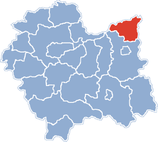
Dąbrowa Tarnowska is a town in Poland, in Lesser Poland Voivodeship, about 16 kilometres (10 mi) north of Tarnów. It is the capital of Dąbrowa County. Before reorganization Dąbrowa Tarnowska was part of Tarnów Voivodeship (1975–1998). Population is 11,402 (2008). Dąbrowa Tarnowska has a rail station on the minor line which joins Tarnów and Szczucin.

Wałdowo Królewskie is a village in the administrative district of Gmina Dąbrowa Chełmińska, within Bydgoszcz County, Kuyavian-Pomeranian Voivodeship, in north-central Poland. It lies 3 kilometres (2 mi) south-west of Dąbrowa Chełmińska, 19 km (12 mi) east of Bydgoszcz, and 28 km (17 mi) north-west of Toruń.
Orłowo is a village in the administrative district of Gmina Inowrocław, within Inowrocław County, Kuyavian-Pomeranian Voivodeship, in north-central Poland. It lies approximately 5 kilometres (3 mi) north of Inowrocław, 33 km (21 mi) south-west of Toruń, and 37 km (23 mi) south-east of Bydgoszcz.
Wierzbick is a village in the administrative district of Gmina Lipno, within Lipno County, Kuyavian-Pomeranian Voivodeship, in north-central Poland. It lies approximately 7 kilometres (4 mi) east of Lipno and 49 km (30 mi) south-east of Toruń.

Szczepanowo is a village in the administrative district of Gmina Dąbrowa, within Mogilno County, Kuyavian-Pomeranian Voivodeship, in north-central Poland. It lies approximately 21 kilometres (13 mi) north of Mogilno and 32 km (20 mi) south of Bydgoszcz.
Samocice is a village in the administrative district of Gmina Bolesław, within Dąbrowa County, Lesser Poland Voivodeship, in southern Poland. It lies approximately 14 kilometres (9 mi) north-west of Dąbrowa Tarnowska and 72 km (45 mi) east of the regional capital Kraków.
Strojców is a village in the administrative district of Gmina Bolesław, within Dąbrowa County, Lesser Poland Voivodeship, in southern Poland. It lies approximately 16 kilometres (10 mi) north of Dąbrowa Tarnowska and 74 km (46 mi) east of the regional capital Kraków.
Kozłów is a village in the administrative district of Gmina Gręboszów, within Dąbrowa County, Lesser Poland Voivodeship, in southern Poland. It lies approximately 4 kilometres (2 mi) north-east of Gręboszów, 17 km (11 mi) north-west of Dąbrowa Tarnowska, and 67 km (42 mi) east of the regional capital Kraków.
Odmęt is a village in the administrative district of Gmina Mędrzechów, within Dąbrowa County, Lesser Poland Voivodeship, in southern Poland. It lies approximately 16 kilometres (10 mi) north of Dąbrowa Tarnowska and 80 km (50 mi) east of the regional capital Kraków.
Kąty is a settlement in the administrative district of Gmina Szczucin, within Dąbrowa County, Lesser Poland Voivodeship, in southern Poland. It lies approximately 4 kilometres (2 mi) south-east of Szczucin, 15 km (9 mi) north-east of Dąbrowa Tarnowska, and 86 km (53 mi) east of the regional capital Kraków.
Mniszew is a village in the administrative district of Gmina Magnuszew, within Kozienice County, Masovian Voivodeship, in east-central Poland. It lies approximately 12 kilometres (7 mi) north-west of Magnuszew, 35 km (22 mi) north-west of Kozienice, and 47 km (29 mi) south-east of Warsaw.

Ostromęczyn is a village in the administrative district of Gmina Platerów, within Łosice County, Masovian Voivodeship, in east-central Poland. It lies approximately 4 kilometres (2 mi) south of Platerów, 10 km (6 mi) north-east of Łosice, and 126 km (78 mi) east of Warsaw.
Turkowy is a village in the administrative district of Gmina Perzów, within Kępno County, Greater Poland Voivodeship, in west-central Poland. It lies approximately 3 kilometres (2 mi) south-east of Perzów, 11 km (7 mi) west of Kępno, and 141 km (88 mi) south-east of the regional capital Poznań.
Dąbrowa Mała is a village in the administrative district of Gmina Ślesin, within Konin County, Greater Poland Voivodeship, in west-central Poland. It lies approximately 3 kilometres (2 mi) south-west of Ślesin, 15 km (9 mi) north of Konin, and 92 km (57 mi) east of the regional capital Poznań.
Dąbek is a village in the administrative district of Gmina Dąbrowa Zielona, within Częstochowa County, Silesian Voivodeship, in southern Poland. It lies approximately 9 kilometres (6 mi) west of Dąbrowa Zielona, 24 km (15 mi) east of Częstochowa, and 73 km (45 mi) north-east of the regional capital Katowice.
Dąbrowa Zielona is a village in Częstochowa County, Silesian Voivodeship, in southern Poland. It is the seat of the gmina called Gmina Dąbrowa Zielona. It lies approximately 31 kilometres (19 mi) east of Częstochowa and 76 km (47 mi) north-east of the regional capital Katowice.
Lipie is a village in the administrative district of Gmina Dąbrowa Zielona, within Częstochowa County, Silesian Voivodeship, in southern Poland. It lies approximately 6 kilometres (4 mi) west of Dąbrowa Zielona, 28 km (17 mi) east of Częstochowa, and 74 km (46 mi) north-east of the regional capital Katowice.
Milionów is a village in the administrative district of Gmina Dąbrowa Zielona, within Częstochowa County, Silesian Voivodeship, in southern Poland. It lies approximately 7 kilometres (4 mi) west of Dąbrowa Zielona, 27 km (17 mi) east of Częstochowa, and 74 km (46 mi) north-east of the regional capital Katowice.
Dąbrowa is a village in the administrative district of Gmina Przystajń, within Kłobuck County, Silesian Voivodeship, in southern Poland. It lies approximately 6 kilometres (4 mi) south of Przystajń, 20 km (12 mi) south-west of Kłobuck, and 69 km (43 mi) north of the regional capital Katowice.
Bartosze is a village in the administrative district of Gmina Ełk, within Ełk County, Warmian-Masurian Voivodeship, in northern Poland. It lies approximately 7 kilometres (4 mi) west of Ełk and 117 km (73 mi) east of the regional capital Olsztyn.