The Huerta de Murcia is an administrative division (comarca) in Murcia, Spain. This natural region encompasses the lands irrigated by the Segura River and its various canals, from the Contraparada weir to the boundary of the Region of Murcia with the Valencian Community. Its principal city is Murcia.
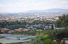
The Segura River valley from the Cordillera Sur, with Murcia city in the background.
The natural comarca of Huerta de Murcia is flanked to the north and south by two mountain ranges that border the Segura River's floodplain and its tributary, the Guadalentín, locally known as El Reguerón.[1]
The comarca extends across the entire municipalities of Alcantarilla, Santomera, and Beniel, as well as most of Murcia. Several outlying districts of Murcia belong to the Campo de Murcia rather than the Huerta.
Administrative Division
The division of the Region of Murcia into comarcas was anticipated in the Statute of Autonomy of the Region of Murcia (1982),[2] but no official comarca subdivision has been legally established yet.
Demographic evolution of Huerta de Murcia (gray line) compared to other comarcas in the region.
History
The fertile valley of the Huerta de Murcia was formed by the sediments of the Quaternary era, deposited by the Segura River and the Guadalentín.
Although the Romans cultivated in the Huerta, the most significant development came with the Muslims, who drained marshlands and built an efficient irrigation system based on the Contraparada.
↑ Díez de Revenga, Pilar; García, Isabel (1992). "History and Language in the Late Medieval Kingdom of Murcia". E.L.U.A. (8): 87. ISSN0212-7636.
This page is based on this Wikipedia article Text is available under the CC BY-SA 4.0 license; additional terms may apply. Images, videos and audio are available under their respective licenses.