
Rincón de Romos is a municipality and city in the Mexican state of Aguascalientes. Located in the northern part of the state, the city serves as the municipal seat of the surrounding municipality Rincón de Romos.

San Francisco de los Romo is a municipality and city in the Mexican state of Aguascalientes. The city of San Francisco de los Romo serves as the municipal seat for the surrounding municipality of San Francisco de los Romo.

Tecate is a municipality in the Mexican state of Baja California. Its municipal seat is located in the city of Tecate. According to the 2020 census, it had a population of 108,440 inhabitants. The municipality has an area of 3,079.0 km².

Playas de Rosarito Municipality is located in the northwestern part of the Mexican state of Baja California comprising part of the Tijuana metropolitan area. It lies just south of the city of Tijuana. Its municipal seat is the city of Rosarito. According to the 2020 census, the municipality had a population of 126,890 inhabitants. Its area is 513.32 km2.

Villaflores is a municipality in the southern Mexican state of Chiapas, and the name of its largest settlement and seat of the municipal government. Situated in the Sierra Madre de Chiapas range, the municipality has an area of approximately 1232 km2 at an average elevation of 540m above mean sea level.

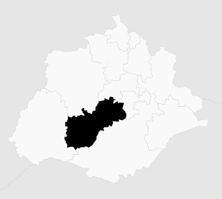
Calvillo is a municipality in the Mexican state of Aguascalientes. The city of Calvillo, the second largest in the state, serves as the municipal seat. It is located to the western part of the state, at about 52 kilometers of the city of Aguascalientes. It stands at 21°51′N102°43′W in the southwestern corner of the state. It is bounded by Jalisco and Zacatecas. The municipality, which has an area of 931.26 km², reported a population of 54,136 by 2010. The town of Ojocaliente is another significant community in the municipality. Calvillo is one of the richest, most prosperous municipalities in Aguascalientes.
Jesús María is a municipality in the Mexican state of Aguascalientes. It stands at 21°58′N102°21′W. As of 2010, the municipality had a total population of 99,590.

Mezquital is a municipality in the Mexican state of Durango. The municipal seat lies at San Francisco del Mezquital. The municipality covers an area of 7,196.5 km².
Mezquital is a city and seat of the Municipality of Mezquital in the state of Durango north-western Mexico. It is situated on the San Pedro Mezquital River in the northeast of the municipality, near the boundary with the Municipality of Suchil. As of 2010, the town had a population of 1,742.

Nombre de Dios is a city and seat of the municipality of Nombre de Dios, established as Pueblo Mágico on October 11, 2018, in the state of Durango, north-western Mexico. As of 2015, the town of Nombre de Dios had a population of 5,302.
Súchil is a city and seat of the municipality of Súchil, in the state of Durango, north-western Mexico. As of 2010, the town of Súchil had a population of 4,107.

Atotonilco de Tula is one of the 84 municipalities of Hidalgo. It is located in the southwestern part of the state of Hidalgo in Mexico. The municipal seat is Atotonilco de Tula. The municipality is located at a southern pass leading out of the Mezquital Valley to 86 kilometers north of Mexico City and about 180 km northeast of the state capital of Pachuca de Soto. The name comes from Nahuatl and means "place of hot springs" and otomi language is Padehe. The municipality covers an area of 31 km².
Chilcuautla is a town and one of the 84 municipalities of Hidalgo, in central-eastern Mexico. The municipality covers an area of 231.3 km².
Omitlán de Juárez is a town and one of the 84 municipalities of Hidalgo, in central-eastern Mexico. The municipality covers an area of 110.5 km².

San Gerónimo Tlamaco is a locality in Mexico belonging to the municipality of Atitalaquia in the state of Hidalgo.

Tlacotlapilco is a town in the municipality of Chilcuautla, in the Mexican state of Hidalgo.
Tunititlán is a town in the municipality of Chilcuautla, in the Mexican state of Hidalgo.
San José Acoculco is a town in the municipality of Atotonilco de Tula in the Mexican state of Hidalgo.

The geography of the State of Hidalgo refers to the physical geography and human geography of Hidalgo, a state in central Mexico.
Pahuayo is a locality in Mexico located in the Municipality of Tlanchinol in the state of Hidalgo.

