
Mexico is a federal republic composed of 32 federative entities : 31 states and Mexico City. According to the Constitution of Mexico, the states of the federation are free and sovereign in all matters concerning their internal affairs. Since 2016, Mexico City was made a fully autonomous entity on par with the states. Each state federative entity has its own congress and constitution.

Chiapas is a state in Southeast Mexico. According to the 2020 Mexican census, it has the eighth largest population of all states with 5,543,828 inhabitants and the 10th largest by land area spanning 73,560.47 square kilometres (28,401.86 sq mi). Chiapas is officially divided into 124 municipalities, although the establishment of municipal authorities in Belisario Domínguez was suspended in 2015 pending the resolution of a territorial dispute between Chiapas and the neighbouring state of Oaxaca. In 2021, the Mexican Supreme Court resolved this dispute in Oaxaca's favour, and annulled the 2011 decree that had created Belisario Domínguez.

San Francisco de los Romo is a municipality and city in the Mexican state of Aguascalientes. The city of San Francisco de los Romo serves as the municipal seat for the surrounding municipality of San Francisco de los Romo.

Municipalities are the administrative divisions under the states of Mexico according to the constitution. Municipalities are considered as the second-level administrative divisions by the federal government. However, some state regulations have designed intrastate regions to administer their own municipalities. Municipalities are further divided into localities in the structural hierarchy of administrative divisions of Mexico. As of December 2024, there are 2,462 municipalities in Mexico.

Mexicali Municipality is a municipality in the Mexican state of Baja California. Its municipal seat is located in the city of Mexicali. As of 2020, the municipality had a total population of 1,049,792. The municipality has an area of 13,700 km2 (5,300 sq mi). This includes many smaller outlying communities as well as the city of Mexicali. Also, the islands of Baja California located in the Gulf of California are part of the municipality, among them the mudflat islands at the mouth of the Colorado River, Isla Ángel de la Guarda and the islands of San Lorenzo Marine Archipelago National Park. Mexicali is the northernmost municipality of Latin America.

Tecate is a municipality in the Mexican state of Baja California. Its municipal seat is located in the city of Tecate. According to the 2020 census, it had a population of 108,440 inhabitants. The municipality has an area of 3,079.0 km².
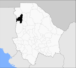
Casas Grandes Municipality is located in the northern Mexican state of Chihuahua. The municipal seat is the town of Casas Grandes, Chihuahua.
San Gregorio Atzompa is a municipality in the Mexican state of Puebla in south-eastern Mexico.
Villa de Pozos is a municipality in the Mexican state of San Luis Potosí. It is located about 10 kilometres (6.2 mi) southeast of the state capital of San Luis Potosí. After being absorbed by the municipality of San Luis Potosí in 1946, it was reestablished as an independent municipality in 2024.

Seybaplaya is a municipality in the Mexican state of Campeche, located 27 kilometres (17 mi) southwest of the state capital of Campeche City. Its creation was approved in 2019 and came into force on 1 January 2021.

Dzitbalché is a municipality in the Mexican state of Campeche, located 73 kilometres (45 mi) northeast of the state capital of Campeche City. Its creation from the municipality of Calkiní was approved in 2019 and went into force on 1 January 2021.

Honduras de la Sierra is a municipality in the Mexican state of Chiapas, located approximately 150 kilometres (93 mi) southeast of the state capital of Tuxtla Gutiérrez. Gazetted in 2019, it is the newest municipality in Chiapas.
Capitán Luis Ángel Vidal is a municipality in the Mexican state of Chiapas, located approximately 138 kilometres (86 mi) southeast of the state capital of Tuxtla Gutiérrez. Its inhabitants are of Guatemalan origin and speak the Mam language.
Rincón Chamula San Pedro is a municipality in the Mexican state of Chiapas, located approximately 54 kilometres (34 mi) north of the state capital of Tuxtla Gutiérrez. Unlike the mestizo population of the surrounding towns, its population is mostly indigenous Tzotzil.
Mezcalapa is a municipality in the Mexican state of Chiapas, located approximately 71 kilometres (44 mi) northwest of the state capital of Tuxtla Gutiérrez. Its municipal seat is Raudales Malpaso.
El Parral is a municipality in the Mexican state of Chiapas, located approximately 45 kilometres (28 mi) south of the state capital of Tuxtla Gutiérrez.
Emiliano Zapata is a municipality in the Mexican state of Chiapas, located approximately 33 kilometres (21 mi) southeast of the state capital of Tuxtla Gutiérrez.
Huitexcalco is a locality in Mexico belonging to the municipality of Chilcuautla in the state of Hidalgo.
Eldorado is a municipality in the Mexican state of Sinaloa. It is located about 55 kilometres (34 mi) south of the state capital of Culiacán. It was created from the municipality of Culiacán in 2021 and it became operational on 1 November 2024.
Pahuayo is a locality in Mexico located in the Municipality of Tlanchinol in the state of Hidalgo.
This page is based on this
Wikipedia article Text is available under the
CC BY-SA 4.0 license; additional terms may apply.
Images, videos and audio are available under their respective licenses.