
Huizum is a residential area of the municipality of Leeuwarden in the province of Friesland, Netherlands. It has approximately 9,000 inhabitants. Huizum was formerly part of Leeuwarderadeel and incorporates a former village.
Huizum is a residential area of the municipality of Leeuwarden in the province of Friesland, Netherlands. It has approximately 9,000 inhabitants. Huizum was formerly part of Leeuwarderadeel and incorporates a former village.
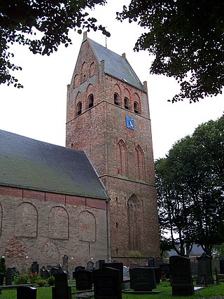
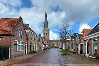
Huizum has three sections: Huizum-West, Huizum-Oost and Huizum-Dorp (Huizum West, Huizum East and Huizum Village). Huizum-Dorp is a former village; Huizum village church , whose oldest section dates to the 12th century, was declared a Rijksmonument in 1967. [1] Huizum-West was developed in the early 20th century. The Hollanderwijk section, built in 1914–1915, was designed by Willem Cornelis de Groot and in 2007 was declared a protected national monument in the category of villages and towns. [2] [3]

Huizum-Dorp was built on a terp, indicating that it was inhabited before the creation of dykes around 1000 CE. The first written record of the settlement is in a letter dated 1149 from Wibald, Abbot of Corvey to the Bishop of Utrecht. In addition to Huizum, which means "by the houses", a reference to stinsen or residences of the nobility once located there, it has in the past been known as Husma, Hwsmanghae and Husum. [4]
Huizum was formerly the administrative centre of Leeuwarderadeel. On 1 January 1944, during the Nazi German occupation, the southern section of Leeuwarderadeel was transferred to Leeuwarden; the town hall remained in Huizum until 1965. [5]

The small village Huizum in Friesland hosts the annual Slauerhoff Lecture. The church in Huizum holds a bronze bust of Slauerhoff's head, made by Ben van der Geest. Several family members of the poet, including his parents, are buried at the Huizum cemetery. The tombstone plate with the names of Slauerhoff's parents has been standing on a pedestal at the entrance of the Dorpskerk ever since the grave was cleared. The tombstone has been given this prominent place because one of Slauerhoff's longest poems (In Memoriam Patris, with 34 stanzas) is dedicated to the burial of his father at the same cemetery.
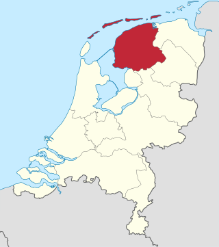
Friesland, historically and traditionally known as Frisia, named after the Frisians, is a province of the Netherlands located in the country's northern part. It is situated west of Groningen, northwest of Drenthe and Overijssel, north of Flevoland, northeast of North Holland, and south of the Wadden Sea. As of January 2023, the province had a population of about 660,000, and a total area of 5,753 km2 (2,221 sq mi).

Leeuwarden is a city and municipality in Friesland, Netherlands, with a population of 127,073 (2023). It is the provincial capital and seat of the Provincial Council of Friesland.

The Elfstedentocht is a long-distance tour skating event on natural ice, almost 200 kilometres (120 mi) long, which is held both as a speed skating competition and a leisure tour. The Elfstedentocht is the biggest ice-skating tour in the world.
Stiens is a town in the municipality of Leeuwarden, Netherlands. As of January 2017, the town had a population of about 7,545. Between 1944 and 2018, it was the capital of the municipality of Leeuwarderadeel.

Koarnjum is a village in the municipality of Leeuwarden, in the Netherlands. The village is situated between Jelsum and Britsum and a population of around 370 in January 2017.

Hillegersberg is a neighbourhood of Rotterdam, Netherlands. Primarily a green residential area with lakes, canals and parks, it was incorporated into the city of Rotterdam in 1941. Settlement around its Hillegonda church was first established here in 990.

The predominant language of the Netherlands is Dutch, spoken and written by almost all people in the Netherlands. Dutch is also spoken and official in Aruba, Bonaire, Belgium, Curaçao, Saba, Sint Eustatius, Sint Maarten and Suriname. It is a West Germanic, Low Franconian language that originated in the Early Middle Ages and was standardised in the 16th century.
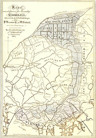
The Middelzee, also called Bordine, was the estuary mouth of the River Boorne now in the Dutch province of Friesland. It ran from as far south as Sneek northward to the Wadden Sea and marked the border between main Frisian regions of Westergoa (Westergo) and Eastergoa (Oostergo). Other historical names for the Middelzee include Bordaa, Borndiep, Boerdiep, and Bordena. The names like Bordine, mean "border".

Rijkswaterstaat, founded in 1798 as the Bureau voor den Waterstaat and formerly translated to Directorate General for Public Works and Water Management, is a Directorate-General of the Ministry of Infrastructure and Water Management of the Netherlands. Its role is the practical execution of the public works and water management, including the construction and maintenance of waterways and roads, and flood protection and prevention. The agency was also involved in the construction of big railway projects such as the Betuweroute and the HSL-Zuid.

Bears is a small village in the Dutch province of Friesland. It is located in the municipality Leeuwarden, about 8 km southwest of Leeuwarden. Bears has a population of about 133 in January 2017.

Burdaard is a village in Noardeast-Fryslân in the province of Friesland, the Netherlands. It had a population of around 1,173 in January 2017. Before 2019, the village was part of the Ferwerderadiel municipality.

Ferwert is a village in Noardeast-Fryslân in the province of Friesland, the Netherlands. It had a population of around 1787 in January 2017. Before 2019, the village was part of the Ferwerderadiel municipality.
Tzum is a village in Waadhoeke municipality in the province of Friesland, the Netherlands. It had a population of around 1,110 in 2023. Tzum is known for its 72 metre tall church tower.

Swichum is a village in Leeuwarden municipality in the province of Friesland, the Netherlands. It had a population of around 50 in January 2017.

Wytgaard is a village in Leeuwarden municipality in the province of Friesland, the Netherlands. It had a population of around 570 in January 2017.

Almenum is a historic locality in the northern Netherlands, near Midlum, Friesland the site of the first Christian church in Friesland. Saint Boniface set up a local church in the locality in 754. The location of the church is on the Terp of Almenum, a mound of earth about five meters high. Almenum is named after the place where someone called "Allaman" lived. The -um suffix is derived from the West Frisian word "hiem" meaning "home". An alternative explanation for the name of the locality is that it originally meant common lands for grazing cattle. In Icelandic this kind of land still uses the term "almenningurheim".

Noardeast-Fryslân is a municipality of Friesland in the northern Netherlands. It was established 1 January 2019 and consists of the former municipalities of Dongeradeel, Ferwerderadiel and Kollumerland en Nieuwkruisland, all three of which dissolved on the same day.

Poptaslot or Heringastate is a stins—a type of luxurious house often used by and/or built for the nobility of Frisia, many of which are built to look like castles —in the Dutch province of Friesland (Fryslân). It was founded somewhere between 1512 and 1525, probably by Sasker van Camstra. It was probably named Heringastate when it was founded, using his mother’s surname Heringa. Around 1631 it was significantly changed and modernised. Its last inhabitant, Doctor Henricus Popta, declared that his house should never be lived in again and should be preserved. Today slot guardians, of which four are currently active, still preserve the stins.
De Vlaren or Vlaren is a hamlet in the Dutch municipality of Waadhoeke in the province of Friesland. It is located northwest of Lollum and southwest of Tzum, of which it is a part administratively. The residences are located on the Lollumerweg as a cluster of loose farms near the Baymerleane.