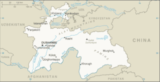
Tajikistan is nestled between Kyrgyzstan and Uzbekistan to the north and west, China to the east, and Afghanistan to the south. Mountains cover 93 percent of Tajikistan's surface area. The two principal ranges, the Pamir Mountains and the Alay Mountains, give rise to many glacier-fed streams and rivers, which have been used to irrigate farmlands since ancient times. Central Asia's other major mountain range, the Tian Shan, skirts northern Tajikistan. Mountainous terrain separates Tajikistan's two population centers, which are in the lowlands of the southern and northern sections of the country. Especially in areas of intensive agricultural and industrial activity, the Soviet Union's natural resource utilization policies left independent Tajikistan with a legacy of environmental problems.

Continental climates often have a significant annual variation in temperature. They tend to occur in central and eastern parts of the three northern-tier continents, typically in the middle latitudes, often within large landmasses, where prevailing winds blow overland bringing some precipitation, and temperatures are not moderated by oceans. Continental climates occur mostly in the Northern Hemisphere due to the large landmasses found there. Most of northeastern China, eastern and southeastern Europe, much of Russia south of the Arctic Circle, central and southeastern Canada, and the central and northeastern United States have this type of climate. Continentality is a measure of the degree to which a region experiences this type of climate.

Kulob or Khatlon is a city in Khatlon Region in southern Tajikistan. Located 203 km (126 mi) southeast of the capital Dushanbe on the river Yakhsu, it is one of the largest cities in the country. Its population is estimated at 106,300 for the city proper and 214,700 for the city with the outlying communities (2020). The city is served by Kulob Airport.

Shahritus is a town in Khatlon Region, southwestern Tajikistan. Situated on the river Kofarnihon, the city was founded in 1938. Its population is 17,200. It is the seat of the Shahritus District.
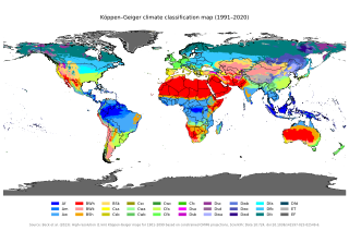
The Köppen climate classification is one of the most widely used climate classification systems. It was first published by German-Russian climatologist Wladimir Köppen (1846–1940) in 1884, with several later modifications by Köppen, notably in 1918 and 1936. Later, German climatologist Rudolf Geiger (1894–1981) introduced some changes to the classification system in 1954 and 1961, which is thus sometimes called the Köppen–Geiger climate classification.

Konibodom is a city in the Sughd Region of northern Tajikistan, in western Fergana Valley. It has a population of 54,400.

Panjakent or Penjikent is a city in the Sughd province of Tajikistan on the river Zeravshan, with a population of 52,500. It was once an ancient town in Sogdiana. The ruins of the old town are on the outskirts of the modern city. The Sarazm Important Bird Area lies downstream of the city on the tugay-vegetated floodplain of the river.

Cuyo is the wine-producing, mountainous region of central-west Argentina. Historically it comprised the provinces of San Juan, San Luis and Mendoza. The modern New Cuyo includes both Cuyo proper and the province of La Rioja. New Cuyo is a political and economic macroregion, but culturally La Rioja is part of the North-West rather than of Cuyo.

The Argentine Northwest is a geographic and historical region of Argentina composed of the provinces of Catamarca, Jujuy, La Rioja, Salta, Santiago del Estero and Tucumán.
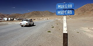
Murghob or Murghab is the capital of Murghob District in the Pamir Mountains of Gorno-Badakhshan, Tajikistan. With a population of just under 7,500, Murghob is the only significant town in the eastern half of Gorno-Badakhshan. It is the highest town in Tajikistan at 3,650 meters above sea level. It is where the Pamir Highway crosses the Bartang river.
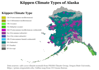
The climate of Alaska is determined by average temperatures and precipitation received statewide over many years. The extratropical storm track runs along the Aleutian Island chain, across the Alaska Peninsula, and along the coastal area of the Gulf of Alaska which exposes these parts of the state to a large majority of the storms crossing the North Pacific. The climate in Juneau and the southeast panhandle is a mid-latitude oceanic climate, in the southern sections and a subarctic oceanic climate in the northern parts. The climate in Southcentral Alaska is a subarctic climate due to its short, cool summers. The climate of the interior of Alaska is best described as extreme and is the best example of a true subarctic climate, as the highest and lowest recorded temperatures in Alaska have both occurred in the interior. The climate in the extreme north of Alaska is an Arctic climate with long, cold winters, and cool summers where snow is possible year-round.
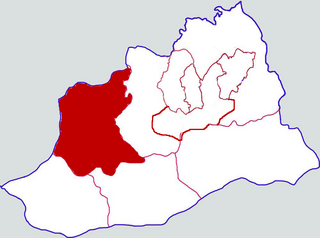
Qinyang is a county-level city in Henan province, China, bordering Shanxi province to the north. It is administered by the prefecture-level city Jiaozuo. The current population of Qinyang is estimated at 470,000. In 1999, the population stood at 444,480.

Hisor or Hisar is a city in western Tajikistan, about 15 km west of Dushanbe. The city was the seat of the former Hisar District, and is part of the Districts of Republican Subordination. It lies at an altitude of 799–824 m, surrounded by high mountains. The river Khanaka, a tributary to the Kofarnihon, flows through the town. Its population is estimated at 29,100 for the city proper and 308,100 for the city with the outlying communities (2020). As of 2002, its population was composed 81.6% of Tajiks, 12.3% Uzbeks, 3.6% Russians, and 2.5% others.
Yovon is a town in Tajikistan located in the Khatlon Region. The population of the town is 36,700. It is approximately 30 kilometres (20 mi) southeast of Dushanbe.

Roghun is a city in Tajikistan. The city was the seat of the former Roghun District, and is part of the Districts of Republican Subordination. Its population is estimated at 14,900 for the city proper and 44,100 for the city with the outlying communities (2020).

Obigarm is a town in Tajikistan. It is part of the city of Roghun in Districts of Republican Subordination. The population of the town is 7,400.
Mu'minobod, previously known as Muminabad, Leningradskiy or Leningrad is a settlement in south Tajikistan. It is the administrative capital of the Mu'minobod District in the eastern part of Khatlon Province, located north-east of the city of Kulob, not far from the Panj River and the international border with Afghanistan. The population of the town is 14,100.

Balkh, before 2017: Kolkhozobod or Kolkhozabad, is a town in Tajikistan and not to be confused with the ancient city of Balkh (Bactra) located in modern-day northern Afghanistan, after which the town was named in 2017. It is the administrative capital of Jaloliddin Balkhi District in the south-west of Khatlon Region.
The Banijurids or Abu Dawudids were a short-lived Iranian dynasty that ruled Tukharistan and parts of the Hindu Kush. They were vassals of the Samanids until their fall in 908.
Jilikul is a village and jamoat in the Khatlon Region, Tajikistan. It is the seat of the Dusti District. It is located in the southwestern portion of Tajikistan approximately 117km from Dushanbe. The jamoat has a total population of 25,382 (2015).


