Related Research Articles

The Jurassic is a geologic period and system that spanned 56 million years from the end of the Triassic Period 201.3 million years ago (Mya) to the beginning of the Cretaceous Period 145 Mya. The Jurassic constitutes the middle period of the Mesozoic Era, also known as the Age of Reptiles. The start of the period was marked by the major Triassic–Jurassic extinction event. Two other extinction events occurred during the period: the Pliensbachian-Toarcian extinction in the Early Jurassic, and the Tithonian event at the end; neither event ranks among the "Big Five" mass extinctions, however.

The Sangre de Cristo Range is a high, rugged and narrow mountain range of the Rocky Mountains in southern Colorado in the United States, running north and south along the east side of the Rio Grande Rift. The mountains extend southeast from Poncha Pass for about 75 mi (121 km) through south-central Colorado to La Veta Pass, approximately 20 mi (32 km) west of Walsenburg, and form a high ridge separating the San Luis Valley on the west from the watershed of the Arkansas River on the east. The Sangre de Cristo Range rises over 7,000 ft (2,100 m) above the valleys and plains to the west and northeast.

An orogeny is an event that leads to both structural deformation and compositional differentiation of the Earth's lithosphere at convergent plate margins. An orogen or orogenic belt develops when a continental plate crumples and is pushed upwards to form one or more mountain ranges; this involves a series of geological processes collectively called orogenesis.

The Humboldt–Toiyabe National Forest (HTNF) is the principal U.S. National Forest in the U.S. state of Nevada, and has a smaller portion in Eastern California. With an area of 6,289,821 acres (25,454.00 km2), it is the largest National Forest of the United States outside Alaska.

The Laramide orogeny was a period of mountain building in western North America, which started in the Late Cretaceous, 70 to 80 million years ago, and ended 35 to 55 million years ago. The exact duration and ages of beginning and end of the orogeny are in dispute. The Laramide orogeny occurred in a series of pulses, with quiescent phases intervening. The major feature that was created by this orogeny was deep-seated, thick-skinned deformation, with evidence of this orogeny found from Canada to northern Mexico, with the easternmost extent of the mountain-building represented by the Black Hills of South Dakota. The phenomenon is named for the Laramie Mountains of eastern Wyoming. The Laramide orogeny is sometimes confused with the Sevier orogeny, which partially overlapped in time and space.
The Piedmont is a plateau region located in the Eastern United States. It sits between the Atlantic coastal plain and the main Appalachian Mountains, stretching from New York in the north to central Alabama in the south. The Piedmont Province is a physiographic province of the larger Appalachian division which consists of the Gettysburg-Newark Lowlands, the Piedmont Upland and the Piedmont Lowlands sections.

The Alpine orogeny or Alpide orogeny is an orogenic phase in the Late Mesozoic (Eoalpine) and the current Cenozoic that has formed the mountain ranges of the Alpide belt. These mountains include the Atlas, the Rif, the Baetic Cordillera, the Cantabrian Mountains, the Pyrenees, the Alps, the Apennine Mountains, the Dinaric Alps, the Pindus (Hellenides), the Carpathians, the Balkanides - Balkan Mountains and Rila-Rhodope massifs, the Pontic Mountains, the Taurus, the Armenian Highlands, the Caucasus, the Alborz, the Zagros, the Hindu Kush, the Pamir, the Karakoram, and the Himalayas. Sometimes other names occur to describe the formation of separate mountain ranges: for example Carpathian orogeny for the Carpathians, Hellenic orogeny for the Pindus, Altai orogeny for Altai Mountains or the Himalayan orogeny for the Himalayas.

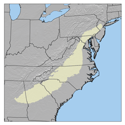
The Alleghanian orogeny or Appalachian orogeny is one of the geological mountain-forming events that formed the Appalachian Mountains and Allegheny Mountains. The term and spelling Alleghany orogeny was originally proposed by H.P. Woodward in 1957.

The Acadian orogeny is a long-lasting mountain building event which began in the Middle Devonian, reaching a climax in the early Late Devonian. It was active for approximately 50 million years, beginning roughly around 375 million years ago, with deformational, plutonic, and metamorphic events extending into the Early Mississippian. The Acadian orogeny is the third of the four orogenies that created the Appalachian orogen and subsequent basin. The preceding orogenies consisted of the Potomac and Taconic orogeny, which followed a rift/drift stage in the Late Neoproterozoic. The Acadian orogeny involved the collision of a series of Avalonian continental fragments with the Laurasian continent. Geographically, the Acadian orogeny extended from the Canadian Maritime provinces migrating in a southwesterly direction toward Alabama. However, the Northern Appalachian region, from New England northeastward into Gaspé region of Canada, was the most greatly affected region by the collision.

The Caledonian orogeny was a mountain-building era recorded in the northern parts of Ireland and Britain, the Scandinavian Mountains, Svalbard, eastern Greenland and parts of north-central Europe. The Caledonian orogeny encompasses events that occurred from the Ordovician to Early Devonian, roughly 490–390 million years ago (Ma). It was caused by the closure of the Iapetus Ocean when the continents and terranes of Laurentia, Baltica and Avalonia collided.
The Variscan or Hercynianorogeny is a geologic mountain-building event caused by Late Paleozoic continental collision between Euramerica (Laurussia) and Gondwana to form the supercontinent of Pangaea.
Not to be confused with the Petermann Orogeny in Central Australia
This timeline of natural history summarizes significant geological and biological events from the formation of the Earth to the arrival of modern humans. Times are listed in millions of years, or megaanni (Ma).
The geology of Arizona began to form in the Precambrian. Igneous and metamorphic crystalline basement rock may have been much older, but was overwritten during the Yavapai and Mazatzal orogenies in the Proterozoic. The Grenville orogeny to the east caused Arizona to fill with sediments, shedding into a shallow sea. Limestone formed in the sea was metamorphosed by mafic intrusions. The Great Unconformity is a famous gap in the stratigraphic record, as Arizona experienced 900 million years of terrestrial conditions, except in isolated basins. The region oscillated between terrestrial and shallow ocean conditions during the Paleozoic as multi-cellular life became common and three major orogenies to the east shed sediments before North America became part of the supercontinent Pangaea. The breakup of Pangaea was accompanied by the subduction of the Farallon Plate, which drove volcanism during the Nevadan orogeny and the Sevier orogeny in the Mesozoic, which covered much of Arizona in volcanic debris and sediments. The Mid-Tertiary ignimbrite flare-up created smaller mountain ranges with extensive ash and lava in the Cenozoic, followed by the sinking of the Farallon slab in the mantle throughout the past 14 million years, which has created the Basin and Range Province. Arizona has extensive mineralization in veins, due to hydrothermal fluids and is notable for copper-gold porphyry, lead, zinc, rare minerals formed from copper enrichment and evaporites among other resources.
The geology of Nevada began to form in the Proterozoic at the western margin of North America. Terranes accreted to the continent as a marine environment dominated the area through the Paleozoic and Mesozoic periods. Intense volcanism, the horst and graben landscape of the Basin and Range Province originating from the Farallon Plate, and both glaciers and valley lakes have played important roles in the region throughout the past 66 million years.
The geology of North Carolina includes ancient Proterozoic rocks belonging to the Grenville Province in the Blue Ridge. The region experienced igneous activity and the addition of new terranes and orogeny mountain building events throughout the Paleozoic, followed by the rifting of the Atlantic Ocean and the deposition of thick sediments in the Coastal Plain and offshore waters.
The Scourian orogeny was an orogeny mountain building event 2.6 billion years ago during the Archean before the beginning of the Laxfordian orogeny (or potentially overlapping with the beginning of the Laxfordian.
The Grampian orogeny was an orogeny mountain building event which affected Scotland in the middle of the Ordovician. At the time, Scotland was part of proto-North American continent Laurentia.
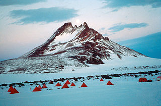
The Beardmore orogeny was a mountain building event in the Neoproterozoic affecting what is now Antarctica. The event is preserved in the Trans-Antarctic Mountains, potentially in the Shackleton Range and by argillite-greywacke series in the Horlick Mountains, Queen Maud Land and the Thiel Mountains. Upright folds, asymmetric overturned or recumbent isoclinal folds first identified by Elliott in 1975 was interpreted in 1992 by Edmund Stump as indicative of compressive and convergent tectonic activity.
References
- ↑ Anderson, John B. (1999). "Antarctic Marine Geology". Cambridge University Press. p. 30-32.
| This article about a regional geological feature is a stub. You can help Wikipedia by expanding it. |
 | This Antarctica-related article is a stub. You can help Wikipedia by expanding it. |